Warren County, North Carolina facts for kids
Quick facts for kids
Warren County
|
|||||
|---|---|---|---|---|---|

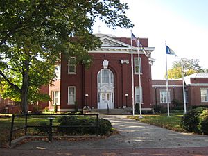
Warren County Courthouse in Warrenton
|
|||||
|
|||||

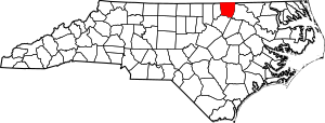
Location within the U.S. state of North Carolina
|
|||||
 North Carolina's location within the U.S. |
|||||
| Country | |||||
| State | |||||
| Founded | 1779 | ||||
| Named for | Joseph Warren | ||||
| Seat | Warrenton | ||||
| Largest community | Warrenton | ||||
| Area | |||||
| • Total | 444.30 sq mi (1,150.7 km2) | ||||
| • Land | 429.39 sq mi (1,112.1 km2) | ||||
| • Water | 14.91 sq mi (38.6 km2) 3.36% | ||||
| Population
(2020)
|
|||||
| • Total | 18,642 | ||||
| • Estimate
(2023)
|
18,836 | ||||
| • Density | 43.42/sq mi (16.76/km2) | ||||
| Time zone | UTC−5 (Eastern) | ||||
| • Summer (DST) | UTC−4 (EDT) | ||||
| Congressional district | 1st | ||||
Warren County is a county in the northeastern Piedmont area of North Carolina. It is located right on the northern border with Virginia. This county is known for a special landfill and for being the starting point of the environmental justice movement.
In 2020, about 18,642 people lived here. The main town and county seat is Warrenton. Long ago, Warren County was a big center for growing tobacco and cotton. It was also important for education and, later, for textile factories.
Contents
History of Warren County
Warren County was created in 1779. It was formed from the northern part of Bute County. The county was named after Joseph Warren from Massachusetts. He was a doctor and a general in the American Revolutionary War. He died during the Battle of Bunker Hill.
The town of Warrenton became the county seat that same year. In 1786, a part of Granville County was added to Warren County. This area grew a lot of tobacco and cotton. From 1840 to 1860, Warrenton was one of the richest towns in North Carolina. Many wealthy farmers built beautiful homes there. Warren County also had one of the largest populations of free Black people in North Carolina before the Civil War.
After the American Civil War, the county's economy became weaker. However, the large Black population had a lot of political power for a short time during the Reconstruction era. Warren County's economy continued to struggle. In the 20th century, some manufacturing businesses came to the area. In 1881, parts of Warren, Franklin, and Granville counties were used to form Vance County.
The economy faced big problems again in the 1970s. By 1980, Warren County was one of the poorest counties in the state. Many people were out of work. The county tried to bring in more industries, but it was difficult. From 1990 to 2016, the number of manufacturing jobs dropped a lot. People have been working to attract new businesses and industries. A "planned community" called Soul City was started with government help. It has not grown as much as planned.
The PCB Issue and Environmental Justice
In 1978, a company illegally dumped harmful chemicals called polychlorinated biphenyls (PCBs) along roads in North Carolina. The state government decided to clean up the pollution. In December 1978, the state bought land in Warren County to build a special landfill for the chemical waste.
Local people quickly started to protest this plan. They argued that there were safer ways to get rid of the waste. They also worried that a hazardous waste site would stop new businesses from coming to the county. Important civil rights groups and politicians joined the protests. In September 1982, about 500 protesters were arrested for trying to stop the landfill from being built.
Even though the protests did not stop the landfill at first, the site was later cleaned up. Many historians believe that these protests in Warren County were the start of the modern environmental justice movement. This movement works to make sure that all people, no matter their race or income, have the right to live in a healthy environment.
Geography of Warren County
Warren County covers about 444 square miles. About 429 square miles are land, and 14.9 square miles (3.36%) are water. It shares borders with several North Carolina counties: Franklin, Halifax, Nash, Northampton, and Vance. It also borders two Virginia counties: Brunswick and Mecklenburg.
The county is in the northeastern part of North Carolina's Piedmont region. Its rivers and streams flow into the Roanoke and Tar-Pamlico river basins.
Protected Areas
These are some protected natural areas in Warren County:
- Embro Game Land (part)
- Kerr Lake State Recreation Area (part)
- Magnolia Ernest Recreation Park
- Shocco Creek Game Land (part)
Major Water Bodies
Here are some of the main rivers and creeks in Warren County:
- Big Stone House Creek
- Fishing Creek
- Hawtree Creek
- John H. Kerr Reservoir
- Jorden Creek
- Lake Gaston
- Nutbush Creek
- Phoebes Creek
- Possumquarter Creek
- Reedy Creek
- Roanoke River
- Sandy Creek
- Shocco Creek
- Sixpound Creek
- Smith Creek
- Walkers Creek
Major Highways
 I-85
I-85 US 1
US 1 US 158


 US 158 Bus.
 US 401
 NC 4
NC 4 NC 43
NC 43 NC 58
NC 58 NC 903
Population of Warren County
| Historical population | |||
|---|---|---|---|
| Census | Pop. | %± | |
| 1790 | 9,379 | — | |
| 1800 | 11,284 | 20.3% | |
| 1810 | 11,004 | −2.5% | |
| 1820 | 11,158 | 1.4% | |
| 1830 | 11,877 | 6.4% | |
| 1840 | 12,919 | 8.8% | |
| 1850 | 13,912 | 7.7% | |
| 1860 | 15,726 | 13.0% | |
| 1870 | 17,768 | 13.0% | |
| 1880 | 22,619 | 27.3% | |
| 1890 | 19,360 | −14.4% | |
| 1900 | 19,151 | −1.1% | |
| 1910 | 20,266 | 5.8% | |
| 1920 | 21,593 | 6.5% | |
| 1930 | 23,364 | 8.2% | |
| 1940 | 23,145 | −0.9% | |
| 1950 | 23,539 | 1.7% | |
| 1960 | 19,652 | −16.5% | |
| 1970 | 15,810 | −19.6% | |
| 1980 | 16,232 | 2.7% | |
| 1990 | 17,265 | 6.4% | |
| 2000 | 19,972 | 15.7% | |
| 2010 | 20,972 | 5.0% | |
| 2020 | 18,642 | −11.1% | |
| 2023 (est.) | 18,836 | −10.2% | |
| U.S. Decennial Census 1790–1960 1900–1990 1990–2000 2010 2020 |
|||
Most of the Black population in Warren County lives near where 13 old plantation sites used to be. The Haliwa-Saponi Native American people mainly live in the southeastern parts of the county. White residents are mostly found in Warrenton and near the county's two large lakes.
2020 Census Information
| Race / Ethnicity (NH = Non-Hispanic) | Pop 2000 | Pop 2010 | Pop 2020 | % 2000 | % 2010 | % 2020 |
|---|---|---|---|---|---|---|
| White alone (NH) | 7,696 | 7,971 | 7,209 | 38.53% | 38.01% | 38.67% |
| Black or African American alone (NH) | 10,816 | 10,911 | 9,049 | 54.16% | 52.03% | 48.54% |
| Native American or Alaska Native alone (NH) | 940 | 1,026 | 953 | 4.71% | 4.89% | 5.11% |
| Asian alone (NH) | 26 | 49 | 62 | 0.13% | 0.23% | 0.33% |
| Pacific Islander alone (NH) | 4 | 3 | 4 | 0.02% | 0.01% | 0.02% |
| Other Race alone (NH) | 8 | 21 | 65 | 0.04% | 0.10% | 0.35% |
| Mixed Race or Multiracial (NH) | 165 | 299 | 561 | 0.83% | 1.43% | 3.01% |
| Hispanic or Latino (any race) | 317 | 692 | 739 | 1.59% | 3.30% | 3.96% |
| Total | 19,972 | 20,972 | 18,642 | 100.00% | 100.00% | 100.00% |
According to the 2020 census, there were 18,642 people living in Warren County. This included 7,786 households and 4,589 families. The county's population actually went down between the 2010 and 2020 censuses.
Economy
In recent years, Warren County has faced challenges with poverty and low wages. Glen Raven, a company that makes textiles, is one of the biggest employers in the county.
Education
Schools in Warren County are part of the Warren County Public Schools system. There is also a branch of Vance-Granville Community College in the county. In 2021, about 15.2% of people in the county had a bachelor's degree or a higher level of education.
Communities
Towns and Cities
These are the main towns in Warren County:
Townships
Warren County is divided into these townships:
- Fishing Creek
- Fork
- Hawtree
- Judkins
- Nutbush
- River
- Roanoke
- Sandy Creek
- Shocco
- Sixpound
- Smith Creek
- Warrenton
Other Communities
Notable People from Warren County
- Braxton Bragg, a general in the Confederate army.
- Thomas Bragg, a U.S. senator and North Carolina governor. He also served as a Confederate attorney general.
- Eva Clayton, a congresswoman.
- Kirkland H. Donald, an Admiral in the U.S. Navy.
- Benjamin Hawkins, a U.S. senator and a leader for Indian Affairs.
- John H. Kerr, a congressman.
- Nathaniel Macon, who was the Speaker of the U.S. House of Representatives and a U.S. senator.
- William Miller, a North Carolina governor.
- Reynolds Price, a famous author and professor.
- Matt Ransom, a U.S. senator and Confederate general.
- Robert Ransom, a Confederate general.
- Gladys Smithwick, a doctor and missionary.
- James Turner, a North Carolina governor.
- Alice Holloway Young, a pioneer in education who helped create the first program for racial integration in the U.S.
See also
 In Spanish: Condado de Warren (Carolina del Norte) para niños
 | Kyle Baker |
 | Joseph Yoakum |
 | Laura Wheeler Waring |
 | Henry Ossawa Tanner |


