Pittsylvania County, Virginia facts for kids
Quick facts for kids
Pittsylvania County
|
||
|---|---|---|

|
||
|
||

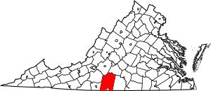
Location within the U.S. state of Virginia
|
||
 Virginia's location within the U.S. |
||
| Country | ||
| State | ||
| Founded | 1767 | |
| Named for | William Pitt | |
| Seat | Chatham | |
| Largest town | Chatham | |
| Area | ||
| • Total | 978 sq mi (2,530 km2) | |
| • Land | 969 sq mi (2,510 km2) | |
| • Water | 9 sq mi (20 km2) 0.9% | |
| Population
(2020)
|
||
| • Total | 60,501 | |
| • Density | 62/sq mi (24/km2) | |
| Time zone | UTC−5 (Eastern) | |
| • Summer (DST) | UTC−4 (EDT) | |
| Congressional district | 5th | |
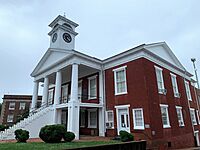
Pittsylvania County is a large area of land in the state of Virginia, USA. It's like a big neighborhood with many towns and communities. In 2020, about 60,501 people lived here. The main town, or "county seat," where the local government offices are, is Chatham.
Pittsylvania County is part of the Danville area. This means it's connected to Danville for things like jobs and community activities.
Did you know that Pittsylvania County has the biggest untouched uranium deposit in the United States? It's also the 7th largest in the world! Uranium is a special metal used for energy.
Contents
History of Pittsylvania County
The name "Pittsylvania" was first thought of for a different British colony. This colony was planned to be in what is now West Virginia. But that idea didn't happen, and the colony was later called Vandalia. Pittsylvania County, as we know it today, was not part of that original plan.
Pittsylvania County was officially created in 1767. It was formed from a part of Halifax County. The county was named after William Pitt, 1st Earl of Chatham. He was like the prime minister of Great Britain from 1766 to 1768. He didn't agree with some of the strict rules Britain had for its colonies in America.
In 1777, the western part of Pittsylvania County became a new county called Patrick Henry County.
Early on, towns didn't grow much in Pittsylvania County. This was because there wasn't a lot of business happening. Also, large farms called "plantations" already offered many of the services that towns usually would. These plantations, especially near rivers, became important places for trade. One important plantation was Green Hill, owned by Sam Pannill.
The county's economy mostly relied on growing tobacco. This work was done by a growing number of enslaved people. For a long time, Pittsylvania County didn't have big towns or a main business center. The plantation villages along the rivers were the only places for trade. This changed when the city of Danville started to grow.
Geography of Pittsylvania County

Pittsylvania County is very large! It covers about 978 square miles (2,533 square kilometers). Most of this area is land (969 square miles or 2,510 square kilometers), and a small part is water (9 square miles or 23 square kilometers). It's the biggest county in Virginia by land area. It's the second largest by total area.
The Roanoke River (also called the Staunton River in this area) forms the northern border of the county. The Banister River flows through the middle of the county from west to east. The Dan River flows through the southern part of the county, also going eastward.
County Districts
The county is divided into seven main areas called districts:
- Banister
- Callands-Gretna
- Chatham-Blairs
- Dan River
- Staunton River
- Tunstall
- Westover
Neighboring Counties and Cities
Pittsylvania County shares borders with other counties and cities: In Virginia:
- Bedford County - Northwest (across Smith Mountain Lake)
- Campbell County - North/Northeast
- Franklin County - West/Northwest
- Halifax County - East
- Henry County - West/Southwest
- Danville - South (Danville is an independent city that is partly inside Pittsylvania County's borders)
In North Carolina:
- Caswell County, North Carolina - South/Southeast
- Rockingham County, North Carolina - South/Southwest
Main Roads
Many important roads run through Pittsylvania County:
 US 29
US 29 US 58
US 58 US 311
 US 360
 SR 40
SR 40 SR 41
SR 41 SR 51
SR 51 SR 57
SR 57 SR 360
Population and People
| Historical population | |||
|---|---|---|---|
| Census | Pop. | %± | |
| 1790 | 11,579 | — | |
| 1800 | 12,697 | 9.7% | |
| 1810 | 17,172 | 35.2% | |
| 1820 | 21,323 | 24.2% | |
| 1830 | 26,034 | 22.1% | |
| 1840 | 26,398 | 1.4% | |
| 1850 | 28,796 | 9.1% | |
| 1860 | 32,104 | 11.5% | |
| 1870 | 31,343 | −2.4% | |
| 1880 | 52,589 | 67.8% | |
| 1890 | 59,941 | 14.0% | |
| 1900 | 46,894 | −21.8% | |
| 1910 | 50,709 | 8.1% | |
| 1920 | 56,493 | 11.4% | |
| 1930 | 61,424 | 8.7% | |
| 1940 | 61,697 | 0.4% | |
| 1950 | 66,096 | 7.1% | |
| 1960 | 58,296 | −11.8% | |
| 1970 | 58,789 | 0.8% | |
| 1980 | 66,147 | 12.5% | |
| 1990 | 55,655 | −15.9% | |
| 2000 | 61,745 | 10.9% | |
| 2010 | 63,506 | 2.9% | |
| 2020 | 60,501 | −4.7% | |
| US Decennial Census 1790-1960 1900-1990 1990-2000 2010 2020 |
|||
2020 Census Information
The 2020 census counted 60,501 people living in Pittsylvania County. Most people identified as White (about 73%). About 20% identified as Black or African American. Other groups, like Asian, Native American, or people of mixed races, made up smaller parts of the population. About 2.8% of the people were of Hispanic or Latino background.
| Race / Ethnicity | Pop 2010 | Pop 2020 | % 2010 | % 2020 |
|---|---|---|---|---|
| White alone (NH) | 47,250 | 44,277 | 74.40% | 73.18% |
| Black or African American alone (NH) | 13,963 | 12,354 | 21.99% | 20.42% |
| Native American or Alaska Native alone (NH) | 124 | 93 | 0.20% | 0.15% |
| Asian alone (NH) | 176 | 289 | 0.48% | 0.28% |
| Pacific Islander alone (NH) | 17 | 17 | 0.03% | 0.03% |
| Some Other Race alone (NH) | 42 | 128 | 0.07% | 0.21% |
| Mixed Race/Multi-Racial (NH) | 602 | 1,631 | 0.95% | 2.70% |
| Hispanic or Latino (any race) | 1,332 | 1,712 | 2.10% | 2.83% |
| Total | 63,506 | 60,501 | 100.00% | 100.00% |
Note: The US Census counts Hispanic/Latino as an ethnic group. This table separates them from the race categories.
2010 Census Information
In 2010, there were 60,949 people living in the county. There were about 26,687 households. About 30% of these households had children under 18 living there. The average household had about 2.28 people.
The average income for a household in the county was around $44,356. The average income per person was about $23,597. Around 12.6% of the people in the county lived below the poverty line.
Communities in Pittsylvania County
Pittsylvania County has several towns and many smaller communities.
Official Towns
These are towns with their own local governments:
Census-Designated Places
These are areas that are like towns but don't have their own local governments:
Other Communities
There are many other smaller communities in Pittsylvania County:
- Ajax
- Bachelors Hall
- Banister
- Beaver Park
- Brosville
- Brights
- Brutus
- Buford
- Callahans Hills
- Callands
- Cartersville
- Cascade
- Cedar Forest
- Cedar Hill
- Chalk Level
- Climax
- Coles Hill
- Dry Fork
- Dundee
- Ebenezer
- Flint Hill
- Galveston
- Glenland
- Grady
- Green Acres
- Green Pond
- Greenfield
- Grit
- Henrys Mill
- Hermosa
- Hill Grove
- Hinesville
- Hollywood
- Hopewell
- Java
- Keeling
- Kentuck
- Lakewood
- Laniers Mill
- Laurel Grove
- Leaksville Junction
- Level Run
- Lucks
- Markham
- Motleys Mill
- Mount Airy
- Mount Cross
- Mountain Hill
- Museville
- Natal
- Peytonsburg
- Pickaway
- Pickerel
- Pittsville
- Pleasant Gap
- Pleasant Grove
- Pullens
- Ray
- Red Oak Hollow
- Redeye
- Renan
- Riceville
- Ridgeway
- Ringgold
- Rondo
- Sandy River
- Sharon
- Sheva
- Shockoe
- Soapstone
- Sonans
- Spring Garden
- Stony Mill
- Straightstone
- Sutherlin
- Swansonville
- Sycamore
- Tightsqueeze
- Toshes
- Transco Village
- Weal
- West Fork
- Whitfield
- Whitmell
- Whittles
- Witt
- Woodlake Park
- Woodlawn
- Worlds
- Vance
- Vandola
See also
 In Spanish: Condado de Pittsylvania para niños
 | Anna J. Cooper |
 | Mary McLeod Bethune |
 | Lillie Mae Bradford |


