Bedford County, Virginia facts for kids
Quick facts for kids
Bedford County
|
|||
|---|---|---|---|

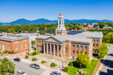
Bedford County Courthouse
|
|||
|
|||

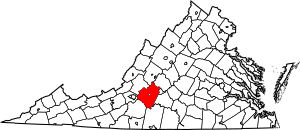
Location within the U.S. state of Virginia
|
|||
 Virginia's location within the U.S. |
|||
| Country | |||
| State | |||
| Founded | 1754 | ||
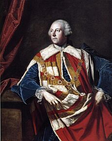
| Named for | John Russell, 4th Duke of Bedford | ||
| Seat | Bedford | ||
| Largest town | Bedford | ||
| Area | |||
| • Total | 769 sq mi (1,990 km2) | ||
| • Land | 753 sq mi (1,950 km2) | ||
| • Water | 16 sq mi (40 km2) 2.1% | ||
| Population
(2020)
|
|||
| • Total | 79,462 | ||
| • Density | 103.33/sq mi (39.897/km2) | ||
| Time zone | UTC−5 (Eastern) | ||
| • Summer (DST) | UTC−4 (EDT) | ||
| Congressional districts | 5th, 9th | ||
Bedford County is a county in the Piedmont region of Virginia. The Piedmont is an area of rolling hills between the mountains and the coast. Its main town is Bedford. This town was an independent city from 1968 until it rejoined the county in 2013.
Bedford County was formed in 1753. It was created from parts of Lunenburg County. Over time, its borders changed a few times until 1786. The county was named after John Russell. He was an English leader and the fourth Duke of Bedford.
Bedford County is part of the Lynchburg area. In 2020, about 79,462 people lived there. The number of people living in the county has more than doubled since 1980.
Contents
History of Bedford County
Long ago, the Piedmont area was home to many indigenous peoples. These were the first people to live in this land. Most of them spoke languages from the Siouan family.
The Virginia General Assembly created Bedford County on December 13, 1753. It was made from parts of Lunenburg County. Later, in 1756, a piece of Albemarle County was added. This part was south of the James River. The county got its name from John Russell. He was a very important government official in Great Britain.
In 1782, Campbell County was formed from the eastern part of Bedford County. The county seat, which is the main government town, moved from New London to Liberty. Liberty is now called Bedford. Also, in 1786, a part of Bedford County was used to create Franklin County. This part was south of the Staunton (Roanoke) River.
The town of Bedford became an independent city in 1968. This meant it was separate from the county for some government things. But it stayed the county seat. On September 14, 2011, the Bedford City Council decided to become a town again. This ended its independent city status. The leaders of Bedford County agreed to welcome the town back. On July 1, 2013, the town of Bedford officially became part of Bedford County again.
Geography
Bedford County covers about 769 square miles. Most of this area, 753 square miles, is land. The rest, about 16 square miles, is water.
Neighboring Areas
Bedford County shares borders with several other counties and one independent city:
- Rockbridge County – to the north
- Amherst County – to the northeast
- Lynchburg, Virginia – to the east (this is an independent city)
- Campbell County – to the southeast
- Pittsylvania County – to the south
- Franklin County – to the southwest
- Roanoke County – to the west
- Botetourt County – to the northwest
Nature Areas
Bedford County has some beautiful natural places:
- Blue Ridge Parkway (part of it runs through the county)
- Jefferson National Forest (part of it is here). This forest has many roads and trails. You can go hiking, horseback riding, or mountain biking. It's also great for seeing wildlife, camping, and taking pictures. There are streams for paddling and fishing too.
- James River Face Wilderness (part)
- Thunder Ridge Wilderness (part)
State Park
- Smith Mountain Lake State Park
Main Roads
These are some of the important highways in Bedford County:
 US 221
 US 460
 US 501
 SR 24
SR 24 SR 43
SR 43 SR 122
Population Information
| Historical population | |||
|---|---|---|---|
| Census | Pop. | %± | |
| 1790 | 10,531 | — | |
| 1800 | 14,125 | 34.1% | |
| 1810 | 16,148 | 14.3% | |
| 1820 | 19,305 | 19.6% | |
| 1830 | 20,246 | 4.9% | |
| 1840 | 20,203 | −0.2% | |
| 1850 | 24,080 | 19.2% | |
| 1860 | 25,068 | 4.1% | |
| 1870 | 25,327 | 1.0% | |
| 1880 | 31,205 | 23.2% | |
| 1890 | 31,213 | 0.0% | |
| 1900 | 30,356 | −2.7% | |
| 1910 | 29,549 | −2.7% | |
| 1920 | 30,669 | 3.8% | |
| 1930 | 29,091 | −5.1% | |
| 1940 | 29,687 | 2.0% | |
| 1950 | 29,627 | −0.2% | |
| 1960 | 31,028 | 4.7% | |
| 1970 | 26,728 | −13.9% | |
| 1980 | 34,927 | 30.7% | |
| 1990 | 45,656 | 30.7% | |
| 2000 | 60,371 | 32.2% | |
| 2010 | 68,676 | 13.8% | |
| 2020 | 79,462 | 15.7% | |
| U.S. Decennial Census 1790-1960 1900-1990 1990-2000 2010 2020 |
|||
2020 Census Details
The 2020 census showed how many people of different backgrounds live in Bedford County.
| Race / Ethnicity (NH = Non-Hispanic) | Pop 2010 | Pop 2020 | % 2010 | % 2020 |
|---|---|---|---|---|
| White alone (NH) | 62,035 | 68,128 | 90.33% | 85.74% |
| Black or African American alone (NH) | 3,909 | 4,864 | 5.69% | 6.12% |
| Native American or Alaska Native alone (NH) | 172 | 167 | 0.25% | 0.21% |
| Asian alone (NH) | 700 | 967 | 1.02% | 1.22% |
| Pacific Islander alone (NH) | 14 | 33 | 0.02% | 0.04% |
| Some Other Race alone (NH) | 47 | 329 | 0.07% | 0.41% |
| Mixed Race or Multi-Racial (NH) | 709 | 2,919 | 1.03% | 3.67% |
| Hispanic or Latino (any race) | 1,090 | 2,055 | 1.59% | 2.59% |
| Total | 68,676 | 79,462 | 100.00% | 100.00% |
Ancestry Groups
In 2017, the largest ancestry groups reported by people in Bedford County were:
Economy
For a long time, farming was the most important part of Bedford County's economy. Farming is still important today. However, many people have built homes in Bedford County. They live there and work in nearby cities like Lynchburg and Roanoke.
Tourism and shopping are also growing in the county. There are also some new businesses and factories near the towns of Forest and New London.
Fun Places to Visit
Bedford County has many interesting places to see:
- Beale ciphers: These are secret codes that supposedly lead to a hidden treasure somewhere in the county. People have been looking for it since the 1800s!
- National D-Day Memorial: A special place to remember the soldiers who fought on D-Day in World War II.
- Peaks of Otter: Beautiful mountains that offer great views and hiking trails.
- Poplar Forest: This was the summer home of Thomas Jefferson, one of America's founding fathers.
- Smith Mountain Lake: A large lake popular for boating, fishing, and swimming.
- Bedford Museum & Genealogical Library: A place to learn about the county's history and its families.
Communities
Town
Census-designated places
These are areas that are like towns but are not officially incorporated as towns.
- Big Island
- Forest
- Moneta
- Montvale
- Stewartsville
Other Communities
These are smaller communities that are not officially towns or census-designated places.
Some of these places use mailing addresses from the town of Bedford or Lynchburg.
Famous People from Bedford County
- Colonel Chaffin (1826 – 1873): He was a little person who traveled around the United States. He was known as the "Virginia Dwarf."
- Erik Estrada (born 1949): A famous American actor. He was known for his role in the TV show CHiPs. He later became a deputy sheriff in Bedford County.
- Carl Overstreet (1929-2015): He was the first U2 pilot to fly over Soviet Air Space.
- Thomas Jefferson: He had a summer home in Bedford County called "Poplar Forest."
- James P. Ownby (1845–1906): An Illinois state representative who was born in Bedford County.
- Lacey Putney: He was born and grew up in Bedford County, Virginia.
See also
 In Spanish: Condado de Bedford (Virginia) para niños
 | Percy Lavon Julian |
 | Katherine Johnson |
 | George Washington Carver |
 | Annie Easley |


