Montvale, Virginia facts for kids
Quick facts for kids
Montvale
|
|
|---|---|

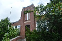
The former Montvale High School on U.S. Route 460
|
|
| Country | United States |
| State | Virginia |
| County | Bedford |
| Area | |
| • Total | 2.416 sq mi (6.26 km2) |
| • Land | 2.414 sq mi (6.25 km2) |
| • Water | 0.002 sq mi (0.005 km2) |
| Population
(2020)
|
|
| • Total | 635 |
| • Density | 262.83/sq mi (101.48/km2) |
| Time zone | UTC−5 (Eastern (EST)) |
| • Summer (DST) | UTC−4 (EDT) |
| ZIP Codes |
24064 (Blue Ridge)
24122 (Montvale) |
| Area code(s) | 540 and 826 |
| FIPS code | 51-52968 |
| GNIS feature ID | 2629032 |
Montvale is a community located in western Bedford County, Virginia, United States. It is called a census-designated place (CDP) because the U.S. Census Bureau uses it for gathering statistics. In 2020, about 635 people lived here. Montvale is found between the cities of Roanoke and Bedford. It is also part of the larger Lynchburg Metropolitan Statistical Area.
Contents
History
A historic place called Locust Level was added to the National Register of Historic Places in 1990. This means it is an important site recognized for its historical value.
Geography
Montvale covers an area of about 2.416 square miles (6.257 square kilometers). This information comes from the United States Census Bureau.
People Living in Montvale
Population Numbers
Montvale's population has changed over the years:
- In 2010, there were 698 people.
- In 2020, the population was 635 people.
| Historical population | |||
|---|---|---|---|
| Census | Pop. | %± | |
| 2010 | 698 | — | |
| 2020 | 635 | −9.0% | |
| Source: U.S. Census Bureau | |||
Who Lives Here?
According to the 2020 census, 635 people lived in Montvale. There were 313 homes. Most people were White (93.4%). There were also African American or Black people (4.7%), American Indian people (0.3%), and Asian people (0.6%). About 1.0% of the population identified as being from two or more races. People of Hispanic or Latino background made up 1.0% of the population.
Economy
Oil Terminal
Montvale used to have an oil terminal that was part of the Colonial Pipeline. This terminal helped move oil for almost 60 years. However, it was closed in 2018. Colonial Pipeline decided to close it because the repairs were too expensive. This closure meant that 20 jobs were lost in the community. In 2020, Colonial said they had no plans to open the pipeline in Montvale again.
Montvale Center for Commerce
The Montvale Center for Commerce is a business area with two parts. It is located along U.S. Route 460. One part is a 19-acre site for commercial businesses, like shops and offices. The other part, across the road, is a 45-acre park for non-commercial businesses and industries.
Parks and Recreation
Montvale Park is a large public park in the community. It covers 129 acres and is managed by the Bedford County Parks and Recreation Department. The park has three soccer fields, a picnic area, and trails for walking.
Education
Students in Montvale attend schools run by Bedford County Public Schools.
- Younger students go to Montvale Elementary School.
- Middle school students attend Liberty Middle School.
- High school students go to Liberty High School.
For higher education, the closest college is a branch campus of Central Virginia Community College. It is located in nearby Bedford.
Infrastructure
The Bedford Regional Water Authority provides public water and wastewater services in Montvale.
Public Safety
- Law Enforcement: The Bedford County Sheriff's Office keeps the community safe.
- Fire Protection: The Montvale Volunteer Fire Department provides fire services. They have a fire station in Montvale.
- Emergency Medical Services: The Montvale Volunteer Rescue Squad provides medical help in emergencies. They also operate from a station in Montvale.
Transportation
Air Travel
The Roanoke-Blacksburg Regional Airport is the closest airport where you can catch commercial flights.
Highways
Montvale is served by important roads:
 US Route 221 (also known as West Lynchburg Salem Turnpike)
 US Route 460 (also known as West Lynchburg Salem Turnpike)
Rail Travel
The Norfolk Southern Blue Ridge District train line runs through Montvale. If you want to take a passenger train, the closest station is the Roanoke station.
See also
 In Spanish: Montvale (Virginia) para niños
 | Selma Burke |
 | Pauline Powell Burns |
 | Frederick J. Brown |
 | Robert Blackburn |


