Blue Ridge, Virginia facts for kids
Quick facts for kids
Blue Ridge, Virginia
|
|
|---|---|

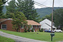
Houses on Oak Drive
|
|

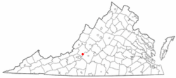
Location of Blue Ridge, Virginia
|
|
| Country | United States |
| State | Virginia |
| County | Botetourt |
| Area | |
| • Total | 6.088 sq mi (15.77 km2) |
| • Land | 6.087 sq mi (15.77 km2) |
| • Water | 0.001 sq mi (0.003 km2) |
| Elevation | 1,263 ft (385 m) |
| Population
(2020)
|
|
| • Total | 3,185 |
| • Density | 523.16/sq mi (201.99/km2) |
| Time zone | UTC−5 (Eastern (EST)) |
| • Summer (DST) | UTC−4 (EDT) |
| ZIP Code |
24064
|
| Area code(s) | 540 and 826 |
| FIPS code | 51-08200 |
| GNIS feature ID | 1499150 |
Blue Ridge is a small community in Botetourt County, Virginia, in the United States. It's called a census-designated place (CDP), which means it's an area that the government counts for population, but it's not an officially organized town or city.
In 2020, about 3,185 people lived in Blue Ridge. The community is located along a main road called U.S. Route 460. Blue Ridge is also part of the larger Roanoke area.
Contents
About Blue Ridge
Where is Blue Ridge?
Blue Ridge is located in southern Botetourt County, Virginia. It covers about 6 square miles (15.77 square kilometers) of land.
How Many People Live Here?
The population of Blue Ridge changes a little over time.
| Historical population | |||
|---|---|---|---|
| Census | Pop. | %± | |
| 2000 | 3,188 | — | |
| 2010 | 3,084 | −3.3% | |
| 2020 | 3,185 | 3.3% | |
| Source: U.S. Census Bureau | |||
In 2020, there were 3,185 people living in Blue Ridge. Most people living here were White (92.0%). There were also African American (2.9%), Asian (0.5%), and American Indian (0.1%) residents. About 4.0% of people were from two or more races.
The average yearly income for families in Blue Ridge was about $86,714 in 2020. Only a small number of people (3.1%) lived below the poverty line.
What People Do in Blue Ridge
Local Economy
Blue Ridge is mostly a "bedroom community." This means many people who live here travel to nearby cities like Roanoke and Salem for work.
However, there are also some businesses in Blue Ridge itself. These include a large quarry (where stone is dug up), an asphalt plant (which makes material for roads), and a brickyard (which makes bricks).
Parks and Fun
Blue Ridge has some great places for outdoor activities!
Boxley Fields Park
This park is managed by Botetourt County. It has baseball fields, a soccer field, and a walking trail. There's even an outdoor classroom for learning!
Blue Ridge Park
Just outside the main community is Blue Ridge Park. This park offers a baseball field, a softball field, and a soccer field. You can also find basketball courts, tennis courts, a walking trail, and a paved track here.
Schools in Blue Ridge
Students in Blue Ridge attend schools run by Botetourt County Public Schools.
Younger students go to Colonial Elementary School. Middle schoolers attend Read Mountain Middle School. For high school, students go to Lord Botetourt High School. If you want to go to college, there are higher education schools nearby in Hollins and Roanoke.
Important Services
Water and Safety
Aqua Virginia provides water to many homes in Blue Ridge.
For safety, the Botetourt County Sheriff's Office handles law enforcement. Fire protection and emergency medical services (like ambulances) are provided by the Botetourt County Department of Fire and EMS. The Blue Ridge Volunteer Fire Department and Rescue Squad also helps, with a fire station right in the community.
Getting Around
Air Travel
The closest airport with flights to other cities is the Roanoke-Blacksburg Regional Airport.
Roads
Several important roads pass through Blue Ridge:
 U.S. Route 221 (also called Blue Ridge Boulevard)
 U.S. Route 460 (also called Blue Ridge Boulevard)
 The famous Blue Ridge Parkway is also nearby.
Trains
A train line operated by Norfolk Southern runs through Blue Ridge. If you want to take a passenger train, the closest station is in Roanoke.
Famous People from Blue Ridge
- Susan Swecker is a notable person from Blue Ridge. She is the chair of the Democratic Party of Virginia.
See also
 In Spanish: Blue Ridge (Virginia) para niños
 | Toni Morrison |
 | Barack Obama |
 | Martin Luther King Jr. |
 | Ralph Bunche |

