Botetourt County, Virginia facts for kids
Quick facts for kids
Botetourt County
|
|||||
|---|---|---|---|---|---|

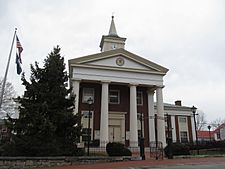
Botetourt County Courthouse
|
|||||
|
|||||

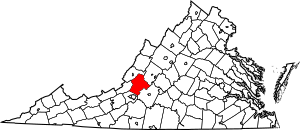
Location within the U.S. state of Virginia
|
|||||
 Virginia's location within the U.S. |
|||||
| Country | |||||
| State | |||||
| Founded | 1770 | ||||
| Named for | Lord Botetourt | ||||
| Seat | Fincastle | ||||
| Largest community | Cloverdale | ||||
| Area | |||||
| • Total | 546 sq mi (1,410 km2) | ||||
| • Land | 541 sq mi (1,400 km2) | ||||
| • Water | 4.7 sq mi (12 km2) 0.9% | ||||
| Population
(2020)
|
|||||
| • Total | 33,596 | ||||
| • Density | 61.53/sq mi (23.757/km2) | ||||
| Time zone | UTC−5 (Eastern) | ||||
| • Summer (DST) | UTC−4 (EDT) | ||||
| Congressional district | 6th | ||||
Botetourt County (pronounced BOT-ə-tot) is a county in the Roanoke Region of Virginia. It's located in the mountainous part of the state. Two big mountain ranges, the Blue Ridge Mountains and the Appalachian Mountains, are right next to it.
Botetourt County was created in 1770. It was named after Norborne Berkeley, 4th Baron Botetourt, who was a governor of Virginia. When it was first formed, the county was huge! It included parts of what are now West Virginia and all of Kentucky. Over time, pieces of Botetourt County were used to create new counties. Its current size and shape were set in 1851.
Botetourt County is part of the larger Roanoke metropolitan area. The main town and county seat is Fincastle. In 2020, about 33,596 people lived in the county.
Contents
History of Botetourt County
The idea to create Botetourt County was first discussed in 1767. It officially became a county in 1770. It was formed from a part of Augusta County.
The county got its name from Norborne Berkeley, 4th Baron Botetourt. He was the governor of the colony of Virginia from 1768 until he passed away in 1770.
Over the years, Botetourt County became smaller as new counties were created from its land. For example, in 1772, Fincastle County was formed. Most of Fincastle County later became the state of Kentucky in 1792. Other counties that were once part of Botetourt County include Rockbridge (1778), Bath (1791), Alleghany (1822), Roanoke (1833), and Craig (1851).
Geography of Botetourt County
Botetourt County covers about 546 square miles. Most of this area, 541 square miles, is land. The rest is water.
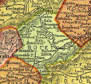
The Blue Ridge Mountains are on the eastern side of the county. The Ridge-and-Valley Appalachians are on the western side. These two mountain ranges get very close to each other near the town of Buchanan and the James River.
The James River actually starts in Botetourt County. It begins near the village of Iron Gate. The river flows south to Eagle Rock, then turns east. It winds through the county, passing places like Springwood and James River High School. Then it reaches Buchanan. From Buchanan, the river flows north into Rockbridge County.
The southern parts of Botetourt County have become more like suburbs in recent years. Many farms and orchards have been replaced by homes and businesses.
Neighboring Counties
- Roanoke County, Virginia - southwest
- Craig County, Virginia - west
- Alleghany County, Virginia - northwest
- Rockbridge County, Virginia - northeast
- Bedford County, Virginia - southeast
Protected Natural Areas
- Blue Ridge Parkway (part)
- George Washington National Forest (part)
- Jefferson National Forest (part)
Main Roads
 I-81
I-81 US 11
US 11 US 220
 US 221
 US 460
 SR 43
SR 43
Population of Botetourt County
| Historical population | |||
|---|---|---|---|
| Census | Pop. | %± | |
| 1790 | 10,524 | — | |
| 1800 | 10,427 | −0.9% | |
| 1810 | 13,301 | 27.6% | |
| 1820 | 13,589 | 2.2% | |
| 1830 | 16,354 | 20.3% | |
| 1840 | 11,679 | −28.6% | |
| 1850 | 14,908 | 27.6% | |
| 1860 | 11,516 | −22.8% | |
| 1870 | 11,329 | −1.6% | |
| 1880 | 14,809 | 30.7% | |
| 1890 | 14,854 | 0.3% | |
| 1900 | 17,161 | 15.5% | |
| 1910 | 17,727 | 3.3% | |
| 1920 | 16,557 | −6.6% | |
| 1930 | 15,457 | −6.6% | |
| 1940 | 16,447 | 6.4% | |
| 1950 | 15,766 | −4.1% | |
| 1960 | 16,715 | 6.0% | |
| 1970 | 18,193 | 8.8% | |
| 1980 | 23,270 | 27.9% | |
| 1990 | 24,992 | 7.4% | |
| 2000 | 30,496 | 22.0% | |
| 2010 | 33,148 | 8.7% | |
| 2020 | 33,596 | 1.4% | |
| U.S. Decennial Census 1790-1960 1900-1990 1990-2000 2010 2020 |
|||
In 2020, the population of Botetourt County was 33,596 people.
Education in Botetourt County
Botetourt County Public Schools runs the public schools in the county. Students attend one of two high schools:
- Lord Botetourt High School opened in Daleville in 1959. It serves the southern parts of the county. This includes places like Blue Ridge, Cloverdale, parts of Fincastle, and Troutville. It also serves the northern suburbs of Roanoke.
- James River High School is in the Springwood area near Buchanan. It also opened in 1959. This school serves the northern parts of the county. This includes Buchanan, Eagle Rock, Springwood, and parts of Fincastle and Troutville.
Emergency Services and Law Enforcement
Botetourt County Fire & EMS helps keep everyone safe. They have both full-time staff and volunteers. They provide fire protection, medical help in emergencies, and teach about fire safety. They also do special rescues, like in water. They work from seven stations and have fire trucks and ambulances.
The Botetourt County Sheriff's Office is in charge of policing the county. Their office and the county jail are in Fincastle, Virginia. The Sheriff is Matthew T. Ward. The Sheriff's Office works closely with the Virginia State Police. The county also has its own Emergency Communications Center. This center takes 9-1-1 calls and helps send police and first responders to emergencies.
Communities in Botetourt County
Towns
Census-designated places
Other Communities
Famous People from Botetourt County
- George A. Anderson (1853–1896), a United States Congressman from Illinois.
- Samuel Barton (1749–1810), an explorer and early settler of Nashville.
- George Louis Alfonso Pogue (1887–1956), an African American doctor. He opened a pharmacy in the 1920s that served everyone.
- Edward Rumsey (1796–1868), a United States Representative from Kentucky.
- Angela Tincher, a talented softball pitcher for Virginia Tech from 2005 to 2008.
- Matthew Ramsey, a songwriter and the lead singer of the band Old Dominion.
See also
 In Spanish: Condado de Botetourt para niños
 | Mary Eliza Mahoney |
 | Susie King Taylor |
 | Ida Gray |
 | Eliza Ann Grier |


