Eagle Rock, Virginia facts for kids
Quick facts for kids
Eagle Rock, Virginia
|
|
|---|---|

Eagle Rock Depot
|
|
| Country | United States |
| State | Virginia |
| County | Botetourt |
| Area | |
| • Total | 0.71 sq mi (1.84 km2) |
| • Land | 0.71 sq mi (1.84 km2) |
| • Water | 0 sq mi (0 km2) |
| Elevation | 971 ft (296 m) |
| Population
(2020)
|
|
| • Total | 209 |
| • Density | 294.4/sq mi (113.6/km2) |
| Time zone | UTC-5 (Eastern (EST)) |
| • Summer (DST) | UTC-4 (EDT) |
| ZIP code |
24085
|
| Area code(s) | 540 |
| FIPS code | 51-51023 |
| GNIS feature ID | 1494212 |
| Other names | Breckenridge, Eagle Mountain, Eaglerock, Rat Hole Sheets |
Eagle Rock is a small community in Botetourt County, Virginia, United States. It is located along the James River. You can find it between the towns of Iron Gate and Buchanan.
Eagle Rock was first officially counted as a "census-designated place" (CDP) in the 2020 census. At that time, its population was 209 people.
Contents
History of Eagle Rock
Eagle Rock has an interesting past, especially concerning how people and goods moved around. It was once home to the very last lock of the James River and Kanawha Canal. A lock is like a water elevator that helps boats move between different water levels.
Making Lime in Eagle Rock
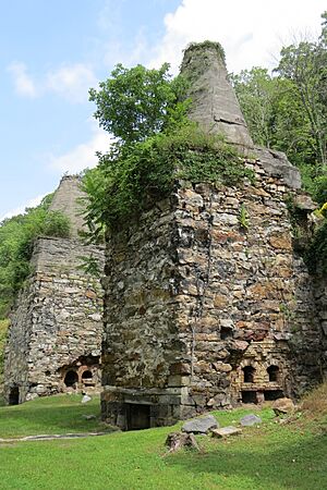
Eagle Rock was an important place for making a material called lime. Lime is used in many things, like building materials and farming. To make lime, people took limestone from nearby. This limestone was then burned in large ovens called kilns.
The limestone was brought across the James River using a special system. At first, wagons pulled by mules crossed the river at a shallow spot called "The Free Stone Ford." Later, in 1884, a bridge was built to help transport the limestone. Even later, tall towers were built, and the lime was sent across the river using cables. You can still find old quarries (places where stone is dug out) on both sides of US 220.
Some important historical sites near Eagle Rock are listed on the National Register of Historic Places. These include the Bessemer Archaeological Site, Phoenix Bridge, and Roaring Run Furnace.
Train Travel and Eagle Rock
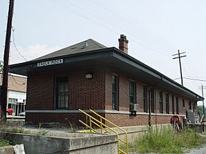
After the canal system, trains became the main way to transport things. Eagle Rock became a key spot for trains. It was where the Richmond and Alleghany Railroad met another line called the Craig Valley Line. The Richmond and Alleghany Railroad later became part of the Chesapeake and Ohio Railway, which is now CSX Transportation. The Craig Valley Line ran all the way to New Castle, Virginia.
Geography of Eagle Rock
Eagle Rock is located at 37°38′26″N 79°48′04″W / 37.64056°N 79.80111°W.
The community covers a total area of about 0.71 square miles (1.84 square kilometers). All of this area is land, with no water.
Population of Eagle Rock
| Historical population | |||
|---|---|---|---|
| Census | Pop. | %± | |
| 2020 | 209 | — | |
| Source: U.S. Census Bureau | |||
As of the 2020 census, there were 209 people living in Eagle Rock. There were also 102 housing units in the area.
Education in Eagle Rock
Students in Eagle Rock attend schools run by Botetourt County Public Schools. Eagle Rock used to have its own high school. However, in the late 1950s, several high schools in northern Botetourt County combined. They formed a new school called James River High School in nearby Springwood.
Today, public school students living in Eagle Rock go to Eagle Rock Elementary School. After elementary school, they attend Central Academy Middle School. Finally, they go to James River High School.
Notable People from Eagle Rock
- William Hanes Ayres (1916–2000) – He was born in Eagle Rock and later became a U.S. Congressman for Ohio.
- Norvel Lee (1924–1992) – An Olympic boxer who represented the United States at the 1952 Summer Olympics in Helsinki.
- Angela Tincher – A talented softball pitcher who played for James River High School and Virginia Tech.
 | Emma Amos |
 | Edward Mitchell Bannister |
 | Larry D. Alexander |
 | Ernie Barnes |


