James River and Kanawha Canal facts for kids
The James River and Kanawha Canal was a waterway built in Virginia. It was meant to help move people and goods by water between western Virginia and the coast. But it was never fully finished. Later, the path next to the canal became a railroad track.
This canal project started in 1785, encouraged by George Washington. It was a very expensive project and faced many money problems. Floods also damaged it often. The Virginia government helped pay for most of it. But by 1851, only half of it was built, reaching a town called Buchanan. By then, railroads were becoming much better for transportation.
After the American Civil War, there was no money to finish the canal. It couldn't compete with railroads. A huge flood in 1877 finally destroyed it. The Richmond and Allegheny Railroad bought the canal's land. They built train tracks on the old towpath. This railroad later became part of the Chesapeake and Ohio Railway. This new rail line became very important for moving bituminous coal from West Virginia to Newport News for export.
Contents
Planning the Canal Route
The idea for the James River and Kanawha Canal came from George Washington. When he was young, he explored the mountains of western Virginia. This area included what is now West Virginia and Kentucky. He wanted to find a water route to the West. He believed this would make Virginia a powerful economic state in the future United States.
In those days, rivers and waterways were the main ways to move goods. Early towns along the East Coast were built where rivers met the ocean. In Virginia, these towns included Alexandria on the Potomac River, Richmond on the James River, and Petersburg on the Appomattox River.
People knew that the Ohio River flowed into the Mississippi River. And the Mississippi flowed into the Gulf of Mexico. They also knew the Allegheny Mountains separated the eastern rivers from the western ones. There was no natural water path between them.
By 1772, Washington thought the Potomac and James rivers were the best places for canals. These canals would connect to the western rivers. He preferred the James River because it would mostly help Virginia. The James could connect with the Kanawha River in what is now West Virginia. In 1785, the James River Company was formed. George Washington, who was busy becoming the first U.S. president, was its honorary president. Their first goal was to build locks around the falls at Richmond.
Building the Canal
Important people like George Washington, Edmund Randolph, and John Marshall supported the James River Company. It opened in 1790 as the first commercial canal in the United States. It stretched about 7 miles (11 km) from Richmond, Virginia to Westham, Virginia. It helped existing boat travel on the James River. Flat-bottomed boats called bateaux floated down the James. They carried tobacco and returned with goods from Europe.
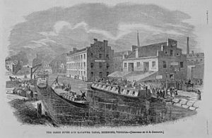
Many canal boats were packets, which were larger than bateaux. Mules and horses pulled these boats along paths next to the canal, called towpaths. Locks were needed where the river had fast-moving water. Wars, like the American Revolutionary War and the War of 1812, slowed down construction. Building the canal was slow, costly, and required a lot of hard work. The land in Virginia's Piedmont was rocky. Many enslaved people, hired from nearby plantation owners, did most of the labor. After a few years, the company ran out of money and stopped work.
In 1820, the Virginia government took over the project. They used state money to restart construction. Work stopped again, but then began once more in 1835. This time, it was under the new James River and Kanawha Company. By 1840, the canal reached Lynchburg. William Henry Harrison, who became president that year, officially opened the service.
The canal eventually reached Buchanan by 1851. This was about 196.5 miles (316 km) west of Richmond. The plan was to connect it to the James River and Kanawha Turnpike. This road would carry goods through the mountains. The final goal was to reach the Kanawha River, near today's Charleston, West Virginia. But moving goods between the canal and the road made it hard to compete with railroads. The American Civil War delayed building a railroad there. The war also damaged the canal and stopped trade, hurting it badly.
Canal vs. Railroads
Railroads started to appear in the 1830s. This was in the middle of the canal's construction. Even after the Civil War (1861–1865), the canal was never fully repaired.
By the time the Chesapeake and Ohio Railway reached the Ohio River in 1873, the canal's future was clear. It couldn't compete. In 1876, the James River and Kanawha Canal Company was allowed to build a railroad to connect the canal's end with the C&O.
In 1878, the Virginia government allowed the canal company to work with the new railroad. However, both the canal and the railroad were sold to the Richmond and Allegheny Railroad company. This company built train tracks right on the canal's old towpaths. Later, this railroad was also sold to the C&O. This made Clifton Forge an important hub for the large east-to-west rail system.
Today, CSX trains carry coal from the mountains along the old canal route. This route is mostly flat, like the canal's water level. The coal goes to the port at Newport News.
Canal's Lasting Impact
|
James River and Kanawha Canal Historic District
|
|

Canal Walk, Richmond, Virginia
|
|
| Nearest city | Richmond, Virginia |
|---|---|
| Area | 138 acres (56 ha) |
| NRHP reference No. | 71000982 |
Quick facts for kids Significant dates |
|
| Added to NRHP | August 26, 1971 |
Richmond Canal Walk
In the late 1900s, parts of the old canal, its locks, and turning basins became popular again. This happened in Richmond, Lynchburg, and other places. As part of Richmond's effort to improve its waterfront, a section of the canal was restored.
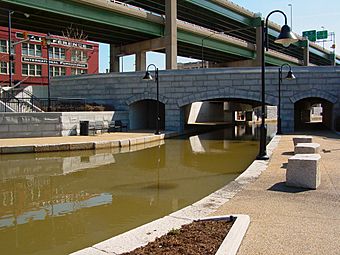
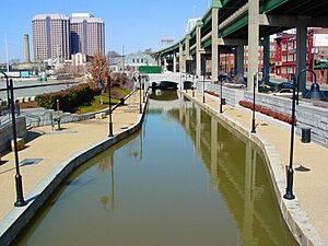
The James River and Kanawha Canal Historic District covers about 138 acres (56 hectares). It was added to the National Register of Historic Places in 1971. Today, you can take boat rides along a Canal Walk. This walk is about 1.25 miles (2 km) long. It runs next to both the old Haxall Canal and the James River and Kanawha Canal. There are also historical displays about the canals and Richmond along the way.
Visitors can also see Three Mile Lock or Pumphouse Park. This park was a spot 3 miles (4.8 km) from the start of the old canal system. It has parts of the old 18th-century locks and a gatekeeper's house. It also has the city's 1901 water pumping station, called the Byrd Park Pumphouse. The city is planning to restore the pumphouse for public use. It might have its old dance floor reopened and offer tours. The park is popular with people who like fishing and dogs.
The western end of the Richmond canal section is near Sabot. The eastern end is in the city near the Richmond Deepwater Terminal. Water for the canal comes from Bosher Dam. This dam was built in 1835 on the western side of the city.
Lock-Keeper's House
The Lock-Keeper's House is a historic home near Cedar Point, Virginia. It was built around 1836. It served Lock Number 7 and is the last lock-keeper's house left from the canal system.
Varney's Falls Dam
Varney's Falls Dam is a historic lock and dam. It is on the south side of the James River near Gilmore Mills, Virginia.
Restored Lock
There is a restored lock in the village of Big Island. It is off the James River where the Blue Ridge Parkway crosses it. You can find a visitor center nearby. The canal lock is on the Bedford County side of the James River. You can reach it by a path and a walkway under the bridge.
Midland Trail
Much of the old James River and Kanawha Turnpike road is now the Midland Trail. This is a special scenic road in West Virginia.
Washington and Lee University
George Washington gave $20,000 worth of stock from the canal to Liberty Hall Academy. This school was in Virginia's Shenandoah Valley. This gift led the Academy to change its name to Washington College. Today, it is known as Washington and Lee University in Lexington, Virginia.
 | Kyle Baker |
 | Joseph Yoakum |
 | Laura Wheeler Waring |
 | Henry Ossawa Tanner |


