Troutville, Virginia facts for kids
Quick facts for kids
Troutville, Virginia
|
||
|---|---|---|

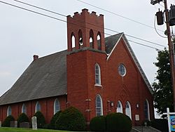
Mill Creek Baptist Church
|
||
|
||

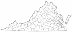
Location of Troutville, Virginia
|
||
| Country | United States | |
| State | Virginia | |
| County | Botetourt | |
| Area | ||
| • Total | 0.69 sq mi (1.79 km2) | |
| • Land | 0.69 sq mi (1.79 km2) | |
| • Water | 0.00 sq mi (0.00 km2) | |
| Elevation | 1,391 ft (424 m) | |
| Population
(2020)
|
||
| • Total | 458 | |
| • Density | 663.77/sq mi (255.87/km2) | |
| Time zone | UTC-5 (Eastern (EST)) | |
| • Summer (DST) | UTC-4 (EDT) | |
| ZIP code |
24175
|
|
| Area code(s) | 540 | |
| FIPS code | 51-79472 | |
| GNIS feature ID | 1493720 | |
| Website | https://townoftroutville-va.gov/ | |
Troutville is a small town in Botetourt County, Virginia, in the United States. In 2020, about 458 people lived there. The town is located along U.S. Route 11. It is found between the towns of Cloverdale and Buchanan. Troutville is part of the larger Roanoke area.
Contents
History of Troutville
The railroad first came to this area in 1881. A train station was built, but the place did not have a name yet. Three brothers named John, Jim, and Jorge Trout lived in nearby houses. Because of them, the area was first called Troutsville.
By the 1890s, Troutsville became an important place for shipping goods. In 1895, it was a busy town. It had active shipping, farms, canneries (places where food is canned), and factories. The name of the town was later changed to Troutville. The town officially became a chartered town on June 4, 1956.
The Thomas D. Kinzie House and Bryan McDonald Jr. House are two historic buildings in Troutville. They are listed on the National Register of Historic Places. This means they are important places that are protected.
Geography and Location
Troutville is located at 37°24′55″N 79°52′37″W / 37.415406°N 79.876967°W. This is its exact spot on a map.
The United States Census Bureau says the town covers about 0.9 square miles (2.3 square kilometers). All of this area is land.
In 2018, leaders in Troutville talked about making the town bigger. They discussed adding about 2,600 acres to the town limits. This would make the town seven times its current size.
Population Information
| Historical population | |||
|---|---|---|---|
| Census | Pop. | %± | |
| 1960 | 524 | — | |
| 1970 | 522 | −0.4% | |
| 1980 | 496 | −5.0% | |
| 1990 | 455 | −8.3% | |
| 2000 | 432 | −5.1% | |
| 2010 | 431 | −0.2% | |
| 2020 | 458 | 6.3% | |
| U.S. Decennial Census | |||
People in 2020
In 2020, there were 458 people living in Troutville. There were 244 homes in the town. Most of the people (93.9%) were White. A small number were African American (0.2%) or Asian (0.4%). About 5.2% of the people were from two or more races. People of Hispanic or Latino background made up 2.0% of the population.
People in 2010
In 2010, there were 431 people living in the town. There were 194 households, which are groups of people living in one home. About 126 of these were families. The town had about 478.9 people per square mile.
- Households:
- 25.8% of households had children under 18.
- 49.5% were married couples living together.
- 12.4% had a female head of household with no husband.
- 35.1% were not families.
- Age Groups:
- 21.3% were under 18 years old.
- 7.6% were from 18 to 24 years old.
- 24.6% were from 25 to 44 years old.
- 26.9% were from 45 to 64 years old.
- 19.7% were 65 years or older.
The average age in Troutville was 41.8 years.
- Income:
The average income for a household was $55,341. For families, it was $56,379. About 5.2% of the people in Troutville lived below the poverty line.
Parks and Outdoor Fun
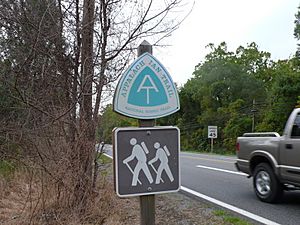
The famous Appalachian Trail crosses U.S. Route 11 just south of Troutville. Troutville has been recognized as an Appalachian Trail Community. This means it is a friendly place for hikers on the trail.
U.S. Bicycle Route 76 also goes through the town. This route is popular with cyclists.
Troutville has one main park called Troutville Town Park. The park has:
- Several shelters
- A quarter-mile paved walking path
- Playground equipment
- Tennis and basketball courts
A Norfolk Southern caboose (the last car on a freight train) is also on display at the park. Hikers and cyclists often use the park. It also hosts many yearly events and festivals.
Education in Troutville
Students in Troutville go to schools run by Botetourt County Public Schools. Children living in Troutville attend:
- Troutville Elementary School
- Read Mountain Middle School
- Lord Botetourt High School
The closest colleges are in Hollins and Roanoke.
Town Services
The town of Troutville manages its own water system. The Western Virginia Water Authority takes care of the town's sewer system.
Getting Around
Air Travel
The Roanoke-Blacksburg Regional Airport is the closest airport for commercial flights.
Roads
Train Travel
The Norfolk Southern train tracks run through Troutville. However, there is no passenger train service directly in Troutville. The closest place to catch a passenger train is at the Roanoke station.
See also
 In Spanish: Troutville (Virginia) para niños
 | Ernest Everett Just |
 | Mary Jackson |
 | Emmett Chappelle |
 | Marie Maynard Daly |


