Craig County, Virginia facts for kids
Quick facts for kids
Craig County
|
|||
|---|---|---|---|

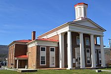
Craig County Courthouse in New Castle
|
|||
|
|||

Location within the U.S. state of Virginia
|
|||
 Virginia's location within the U.S. |
|||
| Country | |||
| State | |||
| Founded | 1851 | ||
| Named for | Robert Craig | ||
| Seat | New Castle | ||
| Largest town | New Castle | ||
| Area | |||
| • Total | 331 sq mi (860 km2) | ||
| • Land | 330 sq mi (900 km2) | ||
| • Water | 1.1 sq mi (3 km2) 0.3% | ||
| Population
(2020)
|
|||
| • Total | 4,892 | ||
| • Density | 14.779/sq mi (5.706/km2) | ||
| Time zone | UTC−5 (Eastern) | ||
| • Summer (DST) | UTC−4 (EDT) | ||
| Congressional district | 9th | ||
Craig County is a special area called a county in the state of Virginia. In 2020, about 4,892 people lived here. The main town and government center is New Castle. Craig County is also part of the larger Roanoke area.
Contents
History of Craig County
Craig County is tucked away in the mountains of Southwest Virginia. It was named after Robert Craig. He was a important person from Virginia who worked in the U.S. Congress in the 1800s.
The first small settlement here was called "Craig's Camp." People say that George Washington himself visited this spot in 1756. He was traveling to the frontier back then.
Craig County was officially created in 1851. It was made from parts of other nearby counties like Botetourt, Roanoke, Giles, and Monroe. Later, even more land was added from other counties.
Historic Buildings in New Castle
The county seat, New Castle, is a quiet town in the mountains. It has some very old government buildings. One of these is the courthouse, built in 1852. It has a grand front porch with columns.
You can also find Craig Healing Springs here. This place has many well-kept buildings from the early 1900s. They show what mountain resorts in Virginia used to look like.
Geography of Craig County
Craig County covers about 330 square miles of land. Only a very small part, about 1 square mile, is water. Most of the county is part of a large national forest.
Neighboring Counties
Craig County shares its borders with several other counties:
- Alleghany County – to the north
- Botetourt County – to the east
- Roanoke County – to the southeast
- Montgomery County – to the south
- Giles County – to the southwest
- Monroe County, West Virginia – to the west
Protected Natural Areas
A part of the Jefferson National Forest is located within Craig County. This is a large area of protected land.
Main Roads
These are the major roads that go through Craig County:
 SR 18
SR 18 SR 42
SR 42 SR 311
People of Craig County
The number of people living in Craig County has changed over the years. Here's a look at the population from past U.S. Census counts:
| Historical population | |||
|---|---|---|---|
| Census | Pop. | %± | |
| 1860 | 3,553 | — | |
| 1870 | 2,942 | −17.2% | |
| 1880 | 3,794 | 29.0% | |
| 1890 | 3,835 | 1.1% | |
| 1900 | 4,293 | 11.9% | |
| 1910 | 4,711 | 9.7% | |
| 1920 | 4,100 | −13.0% | |
| 1930 | 3,562 | −13.1% | |
| 1940 | 3,769 | 5.8% | |
| 1950 | 3,452 | −8.4% | |
| 1960 | 3,356 | −2.8% | |
| 1970 | 3,524 | 5.0% | |
| 1980 | 3,948 | 12.0% | |
| 1990 | 4,372 | 10.7% | |
| 2000 | 5,091 | 16.4% | |
| 2010 | 5,190 | 1.9% | |
| 2020 | 4,892 | −5.7% | |
| U.S. Decennial Census 1790–1960 1900–1990 1990–2000 2010 2020 |
|||
2020 Census Information
In 2020, the U.S. Census counted 4,892 people in Craig County. Most people in the county are White. There are also smaller groups of Black or African American, Native American, Asian, and people of mixed races. Some people are also of Hispanic or Latino background.
| Race / Ethnicity (NH = Non-Hispanic) | Pop 2010 | Pop 2020 | % 2010 | % 2020 |
|---|---|---|---|---|
| White alone (NH) | 5,103 | 4,631 | 98.32% | 94.66% |
| Black or African American alone (NH) | 5 | 11 | 0.10% | 0.22% |
| Native American or Alaska Native alone (NH) | 6 | 5 | 0.12% | 0.10% |
| Asian alone (NH) | 8 | 11 | 0.15% | 0.22% |
| Pacific Islander alone (NH) | 0 | 3 | 0.00% | 0.06% |
| Some Other Race alone (NH) | 1 | 12 | 0.02% | 0.25% |
| Mixed Race or Multi-Racial (NH) | 31 | 166 | 0.60% | 3.39% |
| Hispanic or Latino (any race) | 36 | 53 | 0.69% | 1.08% |
| Total | 5,190 | 4,892 | 100.00% | 100.00% |
Communities in Craig County
Craig County has one main town and several smaller communities.
Town
Unincorporated Communities
These are smaller communities that are not officially towns:
- Abbott
- Maggie
- Paint Bank
- Simmonsville
See also
 In Spanish: Condado de Craig (Virginia) para niños
 | Madam C. J. Walker |
 | Janet Emerson Bashen |
 | Annie Turnbo Malone |
 | Maggie L. Walker |


