Nottoway County, Virginia facts for kids
Quick facts for kids
Nottoway County
|
||
|---|---|---|

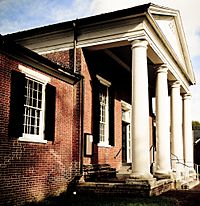
Nottoway County Courthouse
|
||
|
||

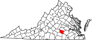
Location within the U.S. state of Virginia
|
||
 Virginia's location within the U.S. |
||
| Country | ||
| State | ||
| Founded | 1789 | |
| Named for | Nottoway people | |
| Seat | Nottoway | |
| Largest town | Blackstone | |
| Area | ||
| • Total | 316 sq mi (820 km2) | |
| • Land | 314 sq mi (810 km2) | |
| • Water | 1.7 sq mi (4 km2) 0.5% | |
| Population
(2020)
|
||
| • Total | 15,642 | |
| • Density | 49.50/sq mi (19.112/km2) | |
| Time zone | UTC−5 (Eastern) | |
| • Summer (DST) | UTC−4 (EDT) | |
| Congressional district | 5th | |
Nottoway County is a place in Virginia, a state in the United States. In 2020, about 15,642 people lived there. Its main town, or "county seat", is Nottoway. It is located south of the James River. This area is known as the Southside Virginia Region.
Contents
A Look Back: Nottoway County's History
Long ago, before Europeans came, the Nadowa tribe lived in this area. They were a group of Iroquoian people. They lived near the Nadowa River. "Nadowa" is an old word meaning "rattlesnake". The county's name, Nottoway, comes from this tribe. Today, the Nottoway Tribe calls themselves Cheroenhaka. This means "People At The Fork Of The Stream". There are about 400 to 500 members now.
Before it was a county, it was called Nottoway Parish. It was part of Amelia County. In 1788, it officially became Nottoway County. The county had many early settlements. These connected new areas in the west with bigger towns like Petersburg and Richmond. For a long time, growing tobacco was very important for the county's success.
In the 1850s, railroads came to Nottoway. This brought new businesses and jobs. By 1860, a large part of the population, 73.2%, were enslaved people. This was the highest percentage in any Virginia county at that time.
One of the county's larger towns, Crewe, started because of a railroad stop in the 1880s. In recent years, the tobacco industry has slowed down. Railroads are not as busy, and Fort Barfoot (once called Fort Pickett) has changed. These changes have made it harder for the county's economy. Many families have moved to Richmond or other cities to find work.
Nottoway County During the Civil War
During the American Civil War, Nottoway County formed two groups of soldiers. These were the Nottoway Rifle Guards and the Nottoway Grays. They also had an artillery group and a cavalry group. Both infantry groups fought in the 18th Virginia Infantry Regiment. They saw a lot of fighting, especially at the Battle of Gettysburg. They were part of a famous attack called Pickett's Charge. This attack was very bad for the 18th Virginia Regiment. Many families in Nottoway County lost loved ones. The flag of the 18th Regiment was captured at Gettysburg. It is now on display there.
Nottoway County had only one major fight during the war. This was the "Battle of the Grove". It happened near Blackstone. The battle was for control of the railroad line. This line supplied General Robert E. Lee's army near Petersburg and Richmond. The last major battle of the war before the surrender happened near Nottoway County. It was fought at Sayler's Creek on April 6, 1865.
Growth and Development in Nottoway
Nottoway's three towns were officially formed in the late 1800s. All of them were built along the U.S. Highway 460 and Norfolk Southern Railway route. This route goes through the middle of the county. Factories and industries grew at this time. It was easy to move raw materials in and finished products out by train. Many factories used the county's natural resources. These included farm products, timber, and wood.
The 1900s brought more variety to the county's farms, factories, and businesses. During this time, important state and federal places were built. Fort Pickett was started when World War II began. It is now the main base for the Virginia National Guard.
Geography and Location
According to the U.S. Census Bureau, Nottoway County covers about 316 square miles (818 square kilometers). Most of this area, about 314 square miles (813 square kilometers), is land. Only a small part, about 1.7 square miles (4.4 square kilometers), is water.
Neighboring Counties
Nottoway County shares its borders with several other counties:
- Amelia County - to the north
- Dinwiddie County - to the east
- Brunswick County - to the southeast
- Lunenberg County - to the south
- Prince Edward County - to the west
Main Roads
Several important highways run through Nottoway County:
 US 360 (W & E Patrick Henry Hwy)
 US 460 (W & E Colonial Trail Hwy)
 SR 40 (S. Main St & Dinwiddie Ave in Blackstone, Kenbridge Rd, Darvills Rd)
 SR 46 (Christianna Hwy)
 SR 49 (Watsons Wood Rd N of Crewe, The Falls Rd S of Crewe)
 SR 153 (Rocky Hill Rd)
 SR 307 (Holly Farms Rd)
Population and People
The population of Nottoway County has changed over the years. Here's a look at how many people have lived there during different census counts:
| Historical population | |||
|---|---|---|---|
| Census | Pop. | %± | |
| 1800 | 9,401 | — | |
| 1810 | 9,278 | −1.3% | |
| 1820 | 9,658 | 4.1% | |
| 1830 | 10,130 | 4.9% | |
| 1840 | 9,719 | −4.1% | |
| 1850 | 8,437 | −13.2% | |
| 1860 | 8,836 | 4.7% | |
| 1870 | 9,291 | 5.1% | |
| 1880 | 11,156 | 20.1% | |
| 1890 | 11,582 | 3.8% | |
| 1900 | 12,366 | 6.8% | |
| 1910 | 13,462 | 8.9% | |
| 1920 | 14,161 | 5.2% | |
| 1930 | 14,866 | 5.0% | |
| 1940 | 15,556 | 4.6% | |
| 1950 | 15,479 | −0.5% | |
| 1960 | 15,141 | −2.2% | |
| 1970 | 14,260 | −5.8% | |
| 1980 | 14,666 | 2.8% | |
| 1990 | 14,993 | 2.2% | |
| 2000 | 15,725 | 4.9% | |
| 2010 | 15,853 | 0.8% | |
| 2020 | 15,642 | −1.3% | |
| U.S. Decennial Census 1790-1960 1900-1990 1990-2000 2010 2020 |
|||
Who Lives in Nottoway County? (2020 Census)
The 2020 census shows the different groups of people living in Nottoway County:
| Race / Ethnicity | Pop 2010 | Pop 2020 | % 2010 | % 2020 |
|---|---|---|---|---|
| White alone (NH) | 8,799 | 8,452 | 55.50% | 54.03% |
| Black or African American alone (NH) | 6,179 | 5,773 | 38.98% | 36.91% |
| Native American or Alaska Native alone (NH) | 42 | 50 | 0.26% | 0.32% |
| Asian alone (NH) | 50 | 64 | 0.32% | 0.41% |
| Pacific Islander alone (NH) | 3 | 3 | 0.02% | 0.02% |
| Some Other Race alone (NH) | 16 | 72 | 0.10% | 0.46% |
| Mixed Race/Multi-Racial (NH) | 155 | 455 | 0.98% | 2.91% |
| Hispanic or Latino (any race) | 609 | 773 | 3.84% | 4.94% |
| Total | 15,853 | 15,642 | 100.00% | 100.00% |
Note: The US Census counts Hispanic/Latino people as an ethnic group. This table separates them from racial groups. Hispanic/Latino people can be of any race.
Towns and Communities
Nottoway County has several towns and one census-designated place:
Towns
Census-Designated Place
- Nottoway Court House (also known as Nottoway)
Famous People from Nottoway County
- Maurice Anderson: A professional football player.
- William Hodges Mann: He was the Governor of Virginia from 1910 to 1914. He also served as a State Senator. He helped create laws to build many high schools in Virginia.
- Peter Randolph: He was a United States federal judge.
Images for kids
See also
 In Spanish: Condado de Nottoway para niños
 | Sharif Bey |
 | Hale Woodruff |
 | Richmond Barthé |
 | Purvis Young |


