Paineville, Virginia facts for kids
Quick facts for kids
Paineville, Virginia
|
|
|---|---|

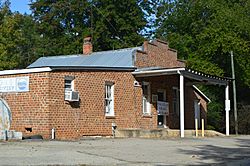
Former country store in Paineville
|
|
| Country | United States |
| State | Virginia |
| County | Amelia |
| Elevation | 453 ft (138 m) |
| Time zone | UTC−5 (Eastern (EST)) |
| • Summer (DST) | UTC−4 (EDT) |
| ZIP codes |
23002, 23083
|
| Area code(s) | 804 |
| GNIS feature ID | 1477604 |
Paineville is a small, rural community in western Amelia County, Virginia. It's a place where people live, but it's not an official town or city.
You can find Paineville where two roads meet: Route 616 (S. Genito Road) and Route 644 (Fowlkes Bridge Road / Rocky Ford Road). The community is located across parts of two ZIP code areas: 23002 (for Amelia Court House) and 23083 (for Jetersville). Paineville has its own fire station, run by volunteers from Amelia County. Also, a part of U.S. Bicycle Route 1, a long bike path, goes right through Paineville.
Paineville's Past
Early Days and Post Office
Paineville was one of the first places in Amelia County to have its own post office. This was way back in 1803! At that time, it was sometimes spelled "Painville" or "Painesville." The post office in Paineville has since closed down.
Civil War Skirmish
On April 5, 1865, during the very last days of the Civil War, something important happened near Paineville. General Robert E. Lee and his army were retreating west. Union soldiers attacked and destroyed a wagon train belonging to the Confederate army. This fight was one of many small battles that happened in the week before General Lee surrendered to Ulysses S. Grant at Appomattox Court House on April 9, 1865.
Paineville School History
In the 1960s, schools in the United States began to allow students of all races to attend together. This was called desegregation. After this change, the historic Paineville School building, located on Route 616, was put up for sale.
Many small schools in the South, like Paineville School, were part of the "Rosenwald School" project. This project built thousands of schools in the early 1900s, mostly for African American children. It's not completely clear if Paineville School was a Rosenwald School, but it was similar to them. As of 2023, the original Paineville School building is still standing. It's now used as an extra building for a nearby house, and the property was recently for sale again.
 | Sharif Bey |
 | Hale Woodruff |
 | Richmond Barthé |
 | Purvis Young |


