Gills, Virginia facts for kids
Quick facts for kids
Gills, Virginia
|
|
|---|---|

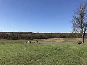
Wheaton Trailhead, Sayler's Creek Battlefield, near Gills
|
|
| Country | United States |
| State | Virginia |
| County | Amelia |
| Elevation | 527 ft (161 m) |
| Time zone | UTC−5 (Eastern (EST)) |
| • Summer (DST) | UTC−4 (EDT) |
| ZIP codes |
23083, 23966, 23922
|
| Area code(s) | 804, 434 |
| FIPS code | 51/30960 |
| GNIS feature ID | 1497787 |
Gills is a small, rural community in Amelia County, Virginia. It's not a city or town with its own government, but rather an "unincorporated community." This means it's a group of homes and businesses that are part of the larger county.
Gills is located about one mile north of the Nottoway county line. It sits at the highest point in Amelia County, which is 527 feet (about 160 meters) above sea level. It's also the westernmost small settlement in the county. Part of U.S. Bicycle Route 1, a long bike path, goes through Gills.
Contents
History of Gills: A Changing Name
The area we now call Gills has had several different names over time. It was once known as New London.
Early Days: Pride's Church
An important early landmark in the area was Pride's Church. This name was used until the mid-1800s. John Pride III was a well-known person in local and state government in the late 1700s.
A post office called "Pride Church" even operated here briefly in the early 1820s. Another post office named "Pride's Church" opened in 1852. Maps from that time show it in the same spot where Gills is today.
Famous Visitors at Pride's Church
The church building itself was simple and old, dating back to the 1700s. But it hosted some famous preachers.
- In 1794, Francis Asbury, a traveling preacher, visited. He was known for his revival meetings.
- In the 1840s, a Presbyterian minister named Moses Drury Hoge gave a sermon there. People said it was an amazing speech.
From Church to Store: Craddock's and Gill's
By the time of the Civil War (around the 1860s), the church was no longer on most maps. Instead, a place called "Craddock's Store" appeared in the same location.
A person named "A. Gills" lived nearby on Pride's Church Road. There was also an establishment called Gill's Mill on Sayler's Creek, just west of the old church site. Later, in the late 1800s, a community called Gill's Store was listed. It received mail from a post office in Deatonville.
Becoming Gills: A Post Office Story
By 1900, a post office officially opened using the name Gills. Today, most of the mail for Gills goes through the post office in Jetersville, which is about seven miles east. Some parts of Gills also get mail from post offices in Rice and Burkeville in nearby counties.
Gills and the Civil War
Gills is located near the path taken by Confederate General Robert E. Lee and his army. This was during their retreat in the final days of the Civil War.
Federal troops and cavalry moved past the old Pride's Church and Gill's Mill. The two sides had their last major battle on April 6, 1865. This battle, known as the Battle of Sayler's Creek, happened just over a mile west of modern-day Gills. It was fought on the border of Amelia and Prince Edward counties.
General Lee surrendered to Ulysses S. Grant at Appomattox just three days later, on April 9. The countryside around the Sayler's Creek battlefield still looks very similar to how it did in the 1860s.
Nearby Historic Site
The Farmer House is a historic building located about three miles east of Gills. It was added to the National Register of Historic Places in 1978, recognizing its importance.
 | Stephanie Wilson |
 | Charles Bolden |
 | Ronald McNair |
 | Frederick D. Gregory |


