Greensville County, Virginia facts for kids
Quick facts for kids
Greensville County
|
||
|---|---|---|

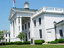
Greensville County Courthouse, also serving the City of Emporia
|
||
|
||

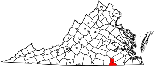
Location within the U.S. state of Virginia
|
||
 Virginia's location within the U.S. |
||
| Country | ||
| State | ||
| Founded | 1780 | |
| Seat | Emporia | |
| Largest town | Jarratt | |
| Area | ||
| • Total | 297 sq mi (770 km2) | |
| • Land | 295 sq mi (760 km2) | |
| • Water | 2 sq mi (5 km2) 0.5% | |
| Population
(2020)
|
||
| • Total | 11,391 | |
| • Density | 38.35/sq mi (14.808/km2) | |
| Time zone | UTC−5 (Eastern) | |
| • Summer (DST) | UTC−4 (EDT) | |
| Congressional district | 4th | |
Greensville County is a county in the state of Virginia. In 2020, about 11,391 people lived there. The main town and center of the county is Emporia.
Contents
History of Greensville County
Greensville County was created in 1781. It was formed from parts of Brunswick County.
How Greensville County Got Its Name
The county might be named after Sir Richard Grenville. He led an early English settlement on Roanoke Island in 1585. Another idea is that it was named for Nathanael Greene. He was a very important general in the Continental Army during the American Revolution. He was one of George Washington's best officers.
Fighting for Equal Rights in Greensville
In May 1940, a local group of the National Association for the Advancement of Colored People (NAACP) started in Greensville County and Emporia. The NAACP is an organization that works for equal rights for all people. Dr. F. A. Sealy led this group.
After Dr. Sealy passed away, efforts began to end segregation in schools. Segregation meant that Black and white students went to separate schools. Attorney Oliver Hill helped with these efforts. Later, Samuel W. Tucker, another attorney, moved to Emporia. He became a key leader in helping to desegregate schools across Virginia.
Geography of Greensville County
Greensville County covers about 297 square miles. Most of this area, 295 square miles, is land. The rest, about 1.6 square miles, is water.
The Meherrin River forms the border between Greensville County and Southampton County.
Neighboring Areas
Greensville County shares borders with several other counties and one independent city:
- Brunswick County, Virginia – to the west
- Dinwiddie County, Virginia – to the north
- Sussex County, Virginia – to the northeast
- Southampton County, Virginia – to the east
- Northampton County, North Carolina – to the south
- Emporia, Virginia – this city is completely surrounded by Greensville County
Main Roads in Greensville County
Several important roads pass through Greensville County:
 I-95: This is a major highway that runs north and south along the Eastern Seaboard. It enters Greensville County from North Carolina. You can get onto it from Exits 4, 8, 11 (which includes Emporia), 12, and 13.
 US 58: This is a main road that goes from west to east through southern Virginia. It connects the Cumberland Gap area of Tennessee to the Hampton Roads area. It enters the county from Brunswick County.
 US 301: This road used to be the main north-south route before I-95 was built. It runs through Historic Emporia.
 SR 139: This state road runs northwest from US 301 through Jarratt. Jarratt is a town that is partly in Greensville and partly in Sussex County.
 SR 186: This state road briefly enters Greensville County from North Carolina. It then crosses into Southampton County over the Meherrin River.
Population of Greensville County
The population of Greensville County has changed over many years. Here is a look at how the number of people living there has grown or shrunk over time.
| Historical population | |||
|---|---|---|---|
| Census | Pop. | %± | |
| 1790 | 6,362 | — | |
| 1800 | 6,727 | 5.7% | |
| 1810 | 6,853 | 1.9% | |
| 1820 | 6,858 | 0.1% | |
| 1830 | 7,117 | 3.8% | |
| 1840 | 6,366 | −10.6% | |
| 1850 | 5,639 | −11.4% | |
| 1860 | 6,374 | 13.0% | |
| 1870 | 6,362 | −0.2% | |
| 1880 | 8,407 | 32.1% | |
| 1890 | 8,230 | −2.1% | |
| 1900 | 9,758 | 18.6% | |
| 1910 | 11,890 | 21.8% | |
| 1920 | 11,606 | −2.4% | |
| 1930 | 13,388 | 15.4% | |
| 1940 | 14,866 | 11.0% | |
| 1950 | 16,319 | 9.8% | |
| 1960 | 16,155 | −1.0% | |
| 1970 | 9,604 | −40.6% | |
| 1980 | 10,903 | 13.5% | |
| 1990 | 8,853 | −18.8% | |
| 2000 | 11,560 | 30.6% | |
| 2010 | 12,243 | 5.9% | |
| 2020 | 11,391 | −7.0% | |
| U.S. Decennial Census 1790–1960 1900–1990 1990–2000 2010 2020 |
|||
Population in 2020
The 2020 census counted 11,391 people in Greensville County. This table shows the different racial and ethnic groups living there.
| Race / Ethnicity (NH = Non-Hispanic) | Pop 2010 | Pop 2020 | % 2010 | % 2020 |
|---|---|---|---|---|
| White alone (NH) | 4,628 | 4,217 | 37.80% | 37.02% |
| Black or African American alone (NH) | 7,294 | 6,616 | 59.58% | 58.08% |
| Native American or Alaska Native alone (NH) | 23 | 19 | 0.19% | 0.17% |
| Asian alone (NH) | 35 | 32 | 0.29% | 0.28% |
| Native Hawaiian or Pacific Islander alone (NH) | 1 | 0 | 0.01% | 0.00% |
| Other race alone (NH) | 10 | 13 | 0.08% | 0.11% |
| Mixed race or Multiracial (NH) | 79 | 218 | 0.65% | 1.91% |
| Hispanic or Latino (any race) | 173 | 276 | 1.41% | 2.42% |
| Total | 12,087 | 11,391 | 100.00% | 100.00% |
Population in 2010
In 2010, there were 12,243 people living in Greensville County. About 59.8% of the people were Black or African American. About 38.5% were White. Other groups included Asian, Native American, and people of two or more races. About 1.4% of the population was Hispanic or Latino.
Communities in Greensville County
Even though Emporia is the county seat, it is an independent city. This means it is not officially part of Greensville County. However, the county and the city share the same public school system.
Town
- Jarratt (partially in Sussex County)
Unincorporated Communities
These are smaller communities that are not officially towns or cities:
Education in Greensville County
The Greensville County Public Schools system runs all the public schools in the county.
See also
 In Spanish: Condado de Greensville para niños
 | Janet Taylor Pickett |
 | Synthia Saint James |
 | Howardena Pindell |
 | Faith Ringgold |


