kids encyclopedia robot

Bon Air, Virginia facts for kids

Kids Encyclopedia Facts
Quick facts for kids
Bon Air, Virginia
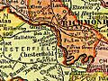
Bon Air is located directly west of Downtown Richmond outside the city limits defined by the Chippenham Parkway on the south side of the James River.
Location of Bon Air, Virginia
Country United States
State Virginia
County Chesterfield
Area
 • Total 8.3 sq mi (21.6 km2)
 • Land 8.3 sq mi (21.6 km2)
 • Water 0.04 sq mi (0.1 km2)
Elevation
328 ft (100 m)
Population
 (2010)
 • Total 16,366
 • Density 1,962/sq mi (757.7/km2)
Time zone UTC−5 (Eastern (EST))
 • Summer (DST) UTC−4 (EDT)
ZIP code
23235
Area code(s) 804
FIPS code 51-08472
GNIS feature ID 1492605

Bon Air is a census-designated place (CDP) in Chesterfield County, Virginia, United States. The population was 16,366 at the 2010 census. The community is considered a suburb of the independent city of Richmond in the Richmond-Petersburg region and is a part of the Southside neighborhoods. Originally developed as a resort, a central portion of Bon Air has been designated as a National Historic District with many structures of Victorian design from the late 19th and early 20th centuries. Its name means "good air," reflecting its role as a resort getaway that wealthy Richmonders enjoyed for its fresh air as opposed to the dirty air of Richmond's industrial downtown of the late 19th century.

History

The area came to be known as Brown's Summit, probably named for the Brown family farm which was located nearby along the old Warwick Road (near the southwest corner of present-day intersection of Belleau Drive and Jahnke and Brown roads).

Brown Road and Belleau Drive each follow portions of the old Warwick Road which are now west of Chippenham Parkway, which severed the old route in the mid-1960s when it was built between present-day Jahnke Road and Midlothian Turnpike.

Old maps

Va 1895 granite
By 1895, Bon Air was under development as a resort for Richmonders, located on the Southern Railway about 8 miles (13 km) west of Manchester (which agreed to merge with the City of Richmond in 1909) and 3 miles (5 km) west of Granite in Chesterfield County, Virginia

An 1864 map, noted as "Published by D. Van Nostrand, New York", and entitled Map of Richmond, Virginia and Surrounding Country appears to show a small cluster of buildings labeled "Pawhite Stop" on the "Railroad to Coal Mines" line at the site of historic Bon Air village. However, it has also been suggested that "Pawhite Stop" (which on the map is "Pawhite STA") is not Bon Air, Virginia. First, it is on what is labeled "Railroad to Coal Mines", and the Richmond and Danville line is several miles south of this. [The railroad to the coal mines was the Chesterfield Railroad which was south of and paralleled Midlothian Turnpike. Midlothian Turnpike is south of Bon Air. The island shown in the James River might be "Williams Island", but there is no actual major creek as shown on the map flowing into the river at this point. If the creek is "Powhite Creek", then the accuracy of the map is even more questionable. This noted, the small stream of Rattle Snake creek flows into the river near Williams Island and originates just to the east of the present-day Bon Air.

A much better map to examine is Survey of a part of Chesterfield County, Virginia. Made under the direction of A.H. Campbell Capt. P.E. & Ch'f Top'l Dep't. by P.W.O. Koerner Lieut. P.E. ; B.F. Blackford and C.E. Cassell Asst. Eng'rs. 1862 & 1863. (This is in the Library of Congress digital collection.) Of particular note is the area owned by "Cogbill" which is in the vicinity of the area near Buford Road near Bon Air Elementary School and Grand Summit subdivision. The "red line" east of "Cogbill" property does approximate the path of the road said to have been near Burroughs Street and crossed the tracks and continued on to Belleau Road where some suggest there was a "flag stop" for Brown's Summit which is west of this near the current (2009) Buford Road bridge over the tracks.

This map does not show a "Pawhite Station" nor any station near what is now "Bon Air, Virginia".

A map in the Virginia State Library - (Virginia Board of Public Works Record #000012006) shows the Richmond and Danville Railroad. Powhite Station is indicated on this map and based on a comparison of the track on this map and current Right of Way of Norfolk Southern Corporation Powhite Station seems to be located west of the Rockaway Road crossing and perhaps even west of Jimmy Winters Creek. Of interest on the map is a notation that Robios Station (west of Powhite Station) is 10 1/2 miles though an early R&D timetable indicates that Powhite was 11 miles.

Bon Air: the resort era

Bon Air Its Attractions for Summer Residents - 1882 - Map of Bon Air Virginia
1882 map of Bon Air, showing the depot, hotel and annex, and dance pavilion, as well as the streets and undeveloped residential parcels
Bon Air Historic District
Bon Air, Virginia is located in Virginia
Bon Air, Virginia
Location in Virginia
Bon Air, Virginia is located in the United States
Bon Air, Virginia
Location in the United States
Nearest city Richmond, Virginia
Area 105 acres (42 ha)
Architectural style Stick style, Queen Anne, Late Victorian
NRHP reference No. 88002178
Significant dates
Added to NRHP November 15, 1988

In the 19th century, it was believed that the higher elevation and distance from the urban area of Richmond provided a more healthful atmosphere, particularly in the hot summer months in central Virginia. With its nearby location and greater elevation, Bon Air offered these features nearby, and was founded as a summer resort town about 8 miles (13 km) outside of Richmond by railroad. One of the founders was Colonel Algernon S. Buford, of Chatham, Virginia, who is best known for his presidency of the Richmond and Danville Railroad during its massive postwar expansion, which ended in 1894 with the formation of the Southern Railway System (now part of Norfolk Southern). Bon Air's connections with the railroad's leaders could possibly be evidenced by the fact that over many of the years until passenger service ended in 1957, the community simultaneously had three stops within 1-mile (2 km) of trackage.

Colonel Buford was a graduate of the University of Virginia. He became a lawyer, and represented Pittsylvania County in the Virginia House of Delegates during 1853 and 1854. During the Civil War, Buford served the Confederacy in Richmond at Virginia Depot, although the title "Colonel" is believed to have been honorary, a southern custom common in the post-slavery years. With the support of Virginia Governor Francis H. Pierpont, on September 13, 1865, Buford became president of the 140-mile (225 km) Richmond and Danville Railroad (R&D).

Around 1875, Buford purchased a large tract of land known as the old Anderson Edwards plantation on the south side of the R&D right-of-way. He personally (as well as through the R&D Railroad) helped in the development of Brown's Summit, which was renamed Grand Summit, then Bon Air, after the French expression for "good air". This choice may also have been related to the earlier settlement by French Huguenots, a group of religious refugees, slightly to the west.

In 1877, Buford was among the first investors and officers in the Bon Air Land and Improvement Company. Other R&D officials involved in the development of Bon Air were General Thomas M. Logan, Andrew Talcott, and his son, Thomas Mann Randolph Talcott. Col. Buford is honored by the naming of the thoroughfare Buford Road in Bon Air. Logan Street is named for General Logan.

Polk Street is named for Bon Air resident Polk Miller, a pharmacist and highly acclaimed banjo player who founded what became Sergeant's Pet Care Products while creating treatments for his favorite hunting dog, Sergeant.

Other prominent residents included Dr. Hunter McGuire who was affiliated with the Medical College of Virginia and several other important hospitals and medical schools (and for whom McGuire Veterans Administration Medical Center in Richmond was named), his wife Mary Stuart McGuire, and their 10 children, many of whom also went into the field of medicine.

Village period

In the 20th century, as the residential area around Richmond grew, Bon Air evolved into a middle-class neighborhood.

In 1911, the new Westham Bridge crossed the James River between Henrico County and Chesterfield County about 7 miles (11 km) upstream from Richmond. Built as a toll bridge, it was named for the nearby Westham Station of the Chesapeake and Ohio Railway in 1911.

The privately owned Westham Bridge was financed by a group headed by developer George Craghead Gregory, who resided at Granite Hall, an estate about a mile from Williams Dam, where he had a mansion erected which was faced with stone quarried nearby. Gregory was also involved with plans to extend a streetcar line from an existing line at Westhampton Park (now the University of Richmond) to Bon Air, which he saw as becoming a "bedroom community" of Richmond. Between the James River and Bon Air, Gregory controlled large land areas along the proposed rail line which he hoped to develop. However, despite his plans, aside from grading of right-of-way all the way from the Westham Bridge to Bon Air, Gregory's planned streetcar line did not materialize. This may have been due to weight issues at the Westham Bridge and/or right-of-way matters in Henrico County. However, portions of the planned and partially improved route can be seen in modern times with the gentle slopes found on present-day Southampton Road and along Mohawk Drive.

After 1933, State Route 147 was routed across the Westham Bridge. It connected River Road and Westham Parkway in Henrico with Southampton Road and the new Huguenot Road in Chesterfield. In 1950, the Westham Bridge, which had been subject to flooding and was inadequate for traffic in the growing suburban area, was replaced by the new Huguenot Memorial Bridge (named in honor of the French Huguenot settlers who came to the area in the eighteenth century to escape religious persecution in France).

The old bridge was dismantled, but the abutments were still visible at each end, and overhead power and telephone lines continued to mark the route for many years. Traces of the old streetcar right-of-way may be seen along gently sloped Southampton Road and Mohawk Drive near Forest Hill Avenue (which was formerly known as Granite Road), and on Logan Street and Hazen Street in Bon Air, where a washboard surface was long rumored by local lore to be the remnants of the streetcar project. Gregory's old mansion, Granite Hall, now located in the Cherokee Estates subdivision near Williams Dam, was still in use as a private residence in 2008. The C&O's Westham Station was relocated to a Richmond city park at Robin Hood Road and Hermitage Road in 1961.

The Southern Railway ended commuter service to Richmond in 1957, and the Bon Air station was dismantled.

The original Southern Railway Station was a building brought to Bon Air from the International Cotton Exposition which had been held in Atlanta, Georgia, in 1881. This station was replaced in 1917, and portions of the original station were used in an old home on the south side of the tracks (still existent in 2005).

Other early stops in the Bon Air area include "The Steps", located on the north side of the tracks near the current Buford Road Bridge, a stop for the Bon Air Inn south of the Inn site on Burroughs Street, and a stop near the current subdivision of Woodmont for the Wherry Farm. This latter station was the only private station on this section of the railroad and was known as Lee Park.

The early railroad alignment through Bon Air may have been to take advantage of a kaolin clay mine said to have been located on the south side of the tracks near the current Buford Road bridge. A plant built in Manchester to process the clay from Bon Air burned before it could go into production, ending the project.

Land for the benefit of children

Bon Air Library
Bon Air Library

Another Confederate civil war veteran came to Bon Air, and like Colonel Buford, General Logan, Polk Miller, and other contemporaries of the time, he (and his wife) were to leave a long-lasting impact upon the community, as well as their family name on a street.

East of the current city limit along Forest Hill Avenue was land which was earlier known as "The Old Burton Place" with an antebellum farmhouse. The land was described by a historian as poor for farming due to the many rocks on the site.

In 1889, the 165-acre (0.7 km2) tract (and the old farmhouse) was purchased by J.R.F. Burroughs, originally of Lynchburg, (then in Campbell County), and his wife Lucy. A childless couple, a few years later the Burroughs opened an orphanage which was originally called "The Home for Friendless Children", and was incorporated in 1898. Religiously devout, the couple never solicited for funds for the orphanage, but there are tales of the support they received anyway. When Mr. Burroughs died in 1915, he was buried at a site now surrounded by neighboring apartments, where his tombstone reads "Faithful unto Death". Burroughs Street in Bon Air was named for the couple.

After he died, the home was taken over by others, and became known as the Bethany Home. It was supported by the community, notably including Bon Air Presbyterian Church, until it closed during the 1940s. A 1936 newspaper article in the Richmond Times-Dispatch stated that over a thousand children had known the farm as "home", maintaining an average of 50 boys and girls at a time. [1]

One of the buildings of the Bethany Home survived into the second half of the twentieth century, and was long used as an adult home for the elderly and disabled. Some of the land north of modern Forest Hill Avenue was still in such use at the beginning of the twenty-first century, where a new nursing home was built in the 1980s. South of the old Granite Road, later renamed Forest Hill Avenue, Chesterfield County built a water tower on part of the property. However, beginning in 1960, children were to return to much of the rest of the land.

The oldest lending Library in Chesterfield County was built in 1902 by the Bon Air Association as a Memorial to Dr. James K. Hazen, minister of Bon Air Presbyterian Church and a literary and educational leader of the community. In 1967 Chesterfield County began to operate the Library and moved the location in 1975, according to a plaque on the building.

By the mid-1950s, Bon Air's elementary school was already in its second home, but most high school students had to travel to Manchester or Midlothian high schools. In the 1960s, a new high school and later a middle school were built by Chesterfield County Public Schools on part of the former Bethany home property. Huguenot High School opened on September 6, 1960. The first principal was G. H. (Gurney Holland) Reid, a longtime principal of Manchester High School, for whom G. H. Reid Elementary School in another section of the county had been named. A fourteen classroom addition was completed around 1964. G. H. Reid retired at the end of the 1968–69 school year, the last before the city annexed the land occupied by the school the following January 1. Also on the former Burroughs land, Fred D. Thompson Middle School, named for a long-time county educator, was completed in 1965, and was one of the first county schools feature central air conditioning.

1970 Richmond-Chesterfield annexation

A portion of what was then considered Bon Air was annexed by the City of Richmond in 1970. In the Bon Air area, Huguenot High School, Thompson Middle School, and J.B. Fisher Elementary School (named for a Midlothian-area physician) were among approximately a dozen schools, support buildings, and future school sites conveyed to the City of Richmond along with 23 square miles (60 km2) of territory as the result of a compromise negotiated during the annexation suit by the City of Richmond against Chesterfield County in the late 1960s. The annexation became effective January 1, 1970. The original Bon Air Elementary School and the newer building and Bon Air Primary School were allowed to remain in the county.

Geography

Bon Air is located at 37°31′12″N 77°34′8″W / 37.52000°N 77.56889°W / 37.52000; -77.56889 (37.519947, −77.568768). The elevation is 328 feet (100 m). The community is located in the Eastern Standard time zone.

According to the United States Census Bureau, the CDP has a total area of 8.36 square miles (21.64 km2), of which 8.32 square miles (21.56 km2) is land and 0.031 square miles (0.08 km2), or 0.38%, is water.

Just west of the fall line, which divides Virginia's Tidewater and Piedmont geological regions, the average elevation in the Bon Air area is approximately 200 feet (60 m) above sea-level, which is significantly higher than most of Richmond, only 8 miles (13 km) to the east. The two branches of Powhite Creek originate nearby, which flows into the James River just upstream from downtown Richmond.

Demographics

Historical population
Census Pop.
1970 10,771
1980 16,224 50.6%
1990 16,423 1.2%
2000 16,213 −1.3%
2010 16,366 0.9%
source:

As of the census of 2000, there were 16,213 people, 6,308 households, and 4,459 families residing in the CDP. The population density was 1,834.1 people per square mile (708.1/km2). There were 6,502 housing units at an average density of 735.5/sq mi (284.0/km2). The racial makeup of the CDP was 86.91% White, 8.43% African American, 0.16% Native American, 2.53% Asian, 0.04% Pacific Islander, 0.85% from other races, and 1.10% from two or more races. Hispanic or Latino of any race were 1.73% of the population.

There were 6,308 households, out of which 32.8% had children under the age of 18 living with them, 58.6% were married couples living together, 9.6% had a female householder with no husband present, and 29.3% were non-families. 24.7% of all households were made up of individuals, and 9.1% had someone living alone who was 65 years of age or older. The average household size was 2.47 and the average family size was 2.97.

In the CDP, the population was spread out, with 26.6% under the age of 18, 5.7% from 18 to 24, 26.3% from 25 to 44, 27.7% from 45 to 64, and 13.7% who were 65 years of age or older. The median age was 40 years. For every 100 females, there were 93.2 males. For every 100 females age 18 and over, there were 85.9 males.

The median income for a household in the CDP was $57,493, and the median income for a family was $67,656. Males had a median income of $42,796 versus $31,551 for females. The per capita income for the CDP was $26,527. About 0.8% of families and 1.8% of the population were below the poverty line, including 0.9% of those under age 18 and 1.8% of those age 65 or over.

Religious life

Places of worship in Bon Air include Buford Road Baptist, Bon Air Presbyterian, St. Joseph Roman Catholic, St. Edward the Confessor Catholic Church, Bon Air Baptist, Bon Air Christian, Bon Air United Methodist, St. Michael's Episcopal Church, Stony Point Reformed Presbyterian, and the Islamic Center of Richmond.

  • Claflin, Mary Anne, and Richardson, Elizabeth Guy (1977) Bon Air: A History, Hale Publishing, Richmond, Virginia


Education

The Chesterfield County Public Schools serving the area are Bon Air Elementary School, Crestwood Elementary School, Greenfield Elementary School, Robious Middle School and James River High School. The independent St. Michael's Episcopal School, Riverside School Inc., St. Edward-Epiphany Catholic School, and Stony Point School are also located in Bon Air. Bon Air Elementary was the inspiration for a series of children's books, The Kids of the Polk Street School by Patricia Reilly Giff.

The Richmond Japanese School (リッチモンド(VA)補習授業校 Ritchimondo Hoshū Jugyō Kō), a Japanese weekend supplementary school, is held at the Bon Air Baptist Church in Bon Air. It was established in 1988.

Images for kids

See also

Kids robot.svg In Spanish: Bon Air (Virginia) para niños

kids search engine
Bon Air, Virginia Facts for Kids. Kiddle Encyclopedia.