
Midlothian, Virginia facts for kids
Quick facts for kids
Midlothian
|
|
|---|---|

Ruins of the Grove Shaft air-pumping station, now part of the Mid-Lothian Mines Park.
|
|

Midlothian
Location in Richmond metropolitan area

Midlothian
Location in Virginia

Midlothian
Location in the United States
|
|
| Country | |
| State | |
| County | Chesterfield |
| Settled | c.1700 |
| Founded | c.1730 |
| Founded by | Wooldridge brothers |
| Named for | Mid-Lothian Mining and Manufacturing Company |
| Area | |
| • Total | 8.64 sq mi (22.4 km2) |
| • Land | 8.568 sq mi (22.19 km2) |
| • Water | 0.072 sq mi (0.19 km2) |
| Elevation | 367 ft (112 m) |
| Population | |
| • Total | 18,320 |
| • Density | 2,120.4/sq mi (818.7/km2) |
| Time zone | UTC-5:00 (EST) |
| • Summer (DST) | UTC-4:00 (EDT) |
| ZIP code |
23112, 23113, 23114
|
| Area code | 804 |
Midlothian (pronounced mid-LOH-thee-un) is a community in Chesterfield County, Virginia, in the United States. It's known as an unincorporated area, meaning it doesn't have its own city government. Instead, it's part of the larger county.
Midlothian started as a coal town and has grown into a busy suburb of Richmond, Virginia. It's located south of the James River in the greater Richmond area. The name "Midlothian" comes from the Mid-Lothian Mining and Manufacturing Company, which was very important in the area's early history. This company was founded by the Wooldridge family in 1836.
Midlothian is famous for being the site of the first place where coal was mined for business in the Colony of Virginia and all of North America.
Contents
Discovering Midlothian's Past
Midlothian has a rich history, especially linked to coal mining and transportation.
How Midlothian Got Its Name
The name "Midlothian" has an interesting story. A popular tale says two brothers from Scotland, one from East Lothian and one from West Lothian, founded the village. They supposedly combined their homelands' names to create "Midlothian."
This story has some truth! The Wooldridge family, who started the Midlothian Coal Mining Company in 1835, owned land called the "Midlothian tract." This land was named after a house owned by their family. The Wooldridge family had connections to the Midlothian region in Scotland, which is where the name originally came from.
From Coal Mines to Midlothian
Before it was called Midlothian, the area was known as "Coal Mines" in the late 1700s. Later, it was called Coalfield. You can still find "Coalfield Road" today, which reminds us of this old name.
When the Richmond and Danville Railroad built a station here in 1850, it was called Coalfield Station. However, the U.S. Post Office at the station was named Midlothian, showing how important the Midlothian Coal Mining Company was. By the late 1800s, everyone started calling the area Midlothian.
Early Settlers and Coal Mining
Long before Europeans arrived, Native American tribes like the Monacan lived here. In the 1700s, French Huguenot settlers came to the area to escape religious persecution. They tried to farm, but the land was challenging.
The real treasure of Midlothian was coal! People with mining skills, especially from Scotland, began digging for coal in the 1700s. In 1709, Midlothian produced the first coal mined for business in the United States. This coal was so important that it even heated the White House for President Thomas Jefferson.
During the American Revolution, coal from Midlothian helped make weapons for the Continental Army. It was shipped to cities all along the East Coast.
Roads and Railroads for Coal
Moving all that coal needed good transportation. In 1804, the Manchester Turnpike was built. This was Virginia's first paved toll road, making it easier to transport coal to the port of Manchester.
By 1824, many wagons carried tons of coal daily on this turnpike. To make transportation even better, the Chesterfield Railroad was built in 1831. It was Virginia's very first railroad! Mules and gravity helped move coal from the mines to Manchester.
Later, in 1852, the faster, steam-powered Richmond and Danville Railroad took over. This railroad passed through Coalfield Station, which was later renamed Midlothian. Today, this railroad line is part of the Norfolk Southern Railway.
Midlothian Today
In the 20th century, coal mining slowed down. Midlothian became a quieter, more rural area with farms. After World War II, new highways and the growth of Richmond led to more homes being built.
When the Swift Creek Reservoir was created in 1965, it provided water and sewer services, which helped the area grow even faster. Large communities like Brandermill were developed.
Today, Midlothian has expanded far beyond its original village. Major roads like State Route 288 and U.S. Route 60 connect it to the wider Richmond area.
Where is Midlothian?
Midlothian is located in the Piedmont region of Virginia. This area has rolling hills and fertile land. It sits on the Richmond Basin, which is known for its sedimentary rock and bituminous coal deposits.
Midlothian is also where several creeks begin, like Swift Creek and Falling Creek, which eventually flow into the James River. The Swift Creek Reservoir is a main source of fresh water for the county.
People of Midlothian
In 2020, the Midlothian area had a population of 72,711 people living in 26,206 homes. The community is diverse, with people from many different backgrounds. In 2019, the average household income was $89,851.
Midlothian's Economy and Growth
Midlothian has been recognized as a great place to live. In 2005, CNNMoney ranked it #37 on its list of "The Best Places to Live."
The community has seen a lot of development. In 2004, the completion of State Route 288 helped connect Midlothian to the larger highway system around Richmond. This led to new projects like the Watkins Centre, a large complex with offices and shops.
Midlothian also has important services, including the Bon Secours St. Francis Hospital. The area is home to excellent schools, with James River High School and Cosby High School both winning the President's Blue Ribbon School of Excellence Award.
Historic Places to See
Midlothian has many historic landmarks that tell the story of its past.
Midlothian Mines Park
The Midlothian Mines Park is a special place. It's built on the site of the first commercially mined coal deposits in Virginia. The park opened in 2004 and helps visitors learn about the area's important mining history.
Other Historic Landmarks
Some other historic places near Midlothian Village include:
- Bellona Arsenal
- Bethel Baptist Church
- Bellgrade Plantation
- Trabue's Tavern
- Hallsboro Store
- Hallsborough Tavern
- Ivymont Manor (built in 1850)
- Southside Speedway
- A visible part of the old Chesterfield Railroad roadbed.
Chesterfield Museum
The Chesterfield Museum has an exhibit about the local mining history. You can see a piece of iron rail from the old incline railway, which was the first of its kind in Virginia.
Famous People from Midlothian
Many notable people have connections to Midlothian, including:
- DaShaun Amos, a professional football player
- Aimee Mann, a musician
- Jesse Jefferson, a former baseball pitcher for the Toronto Blue Jays
- Edward Johnson, a major general in the Confederate States Army
- Richard Kelly, a filmmaker
- Alex McMurtry, a gymnast
- Shannon Taylor, an Olympic field hockey player
Midlothian in Pop Culture
The filmmaker Richard Kelly grew up in Midlothian. His cult film Donnie Darko features a fictional town called Middlesex, Virginia, which was inspired by his memories of Midlothian. He described it as a "stylized, satirical, comic book, fantasyland version" of the area.
Images for kids
-
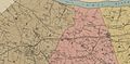
This map from 1888 shows the Midlothian Mines area. The Chesterfield Railroad was replaced by the Richmond and Danville railroad in the 1850s.
-
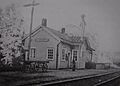
The Midlothian train station in the late 1940s.
.jpg)

