
Chickahominy River facts for kids
Quick facts for kids Chickahominy River |
|
|---|---|

Chickahominy near Mechanicsville, Virginia
|
|

Map of the James River watershed with the Chickahominy highlighted
|
|
| Country | United States |
| State | Virginia |
| Physical characteristics | |
| River mouth | James River |
| Basin features | |
| Tributaries |
|
The Chickahominy River is a river in the eastern part of Virginia, USA. It is about 87 miles (140 km) long. The river starts about 15 miles (24 km) northwest of Richmond. It then flows southeast and south until it reaches the James River. This river forms the eastern border of Charles City County.
The river gets its name from the Chickahominy Indian tribe. They lived near the river when English settlers arrived in 1607. Today, descendants of the Chickahominy tribe still live in Charles City County.
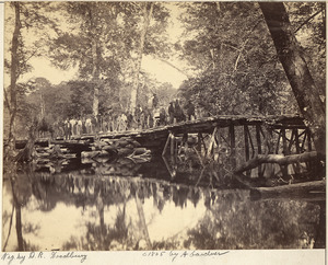
During the American Civil War (1861–1865), the upper part of the river became a big challenge for the Union Army. General George B. McClellan tried to capture the Confederate capital of Richmond in 1862. The river was usually easy to cross when dry. But after heavy rains, it would flood, creating swamps up to a mile wide. This flooding often split the Union Army, even with efforts to build bridges. Other battles also happened near the river in 1864.
Today, the lower Chickahominy River is a popular spot for fun activities. People enjoy boating, waterskiing, and fishing there. It also provides drinking water for many towns on the Virginia Peninsula. The river also borders the Chickahominy Wildlife Management Area.
Contents
How the Chickahominy River Formed
The Chickahominy River is a river that flows into the James River. It starts northwest of Richmond. For its first 15 miles (24 km), the river flows over hard rocks like igneous and metamorphic rocks. These rocks are part of the Piedmont region.
Then, near Mechanicsville, it becomes a "Coastal Plain" stream. Here, the river flows slowly through wide, swampy areas for about 40 miles (64 km). This area stretches from Henrico County to eastern New Kent County. About 4 miles (6 km) southeast of Providence Forge, the Chickahominy River becomes an estuary. An estuary is where the river meets the sea, and the water becomes a mix of fresh and salt water.
Long ago, when the sea level was higher, the Chickahominy River was much wider. This happened during warmer times when there were no big glaciers. You can still see the old riverbanks and curves from that time. As the sea level rose after the last ice age (about 20,000 years ago), the river also rose. This caused old floodplains and valleys to fill up and become marshes.
History of the Chickahominy River
In 1607, Captain John Smith, one of the settlers from Jamestown, explored the Chickahominy River. He hoped it would lead to the Pacific Ocean. Instead, warriors from the Chickahominy tribe captured him. They took him to meet their leader, Chief Powhatan. A famous story says that Powhatan's daughter, Matoaka, also known as Pocahontas, saved him.
In the 1800s, many parts of the Chickahominy River were surrounded by swampy forests. When it rained a lot or snow melted in spring, these areas would flood. The river, usually narrow, could become a mile wide. This small river became a huge natural challenge during the American Civil War (1861–1865).
The River's Role in the Civil War
1862: The Peninsula Campaign

In the spring and summer of 1862, General George B. McClellan led the Union Army up the Virginia Peninsula. His goal was to capture Richmond, the capital of the Confederacy. After some battles, the Confederates retreated. They crossed the Chickahominy River near where New Kent, Henrico, and Hanover counties meet. This area is now known as Bottoms Bridge.
Soon after the Union forces were on both sides of the river, heavy rains began. The river and swamps flooded, making them almost impossible to cross. This split the Union army in two. Even though the two halves were close, they could only reach each other by a bridge many miles away.
General Joseph E. Johnston, who led the Confederate Army of Northern Virginia, decided to attack the Union troops south of the river. He wanted to defeat them before the rest of the Union army could help. The attack happened in two places: Fair Oaks and Seven Pines. At first, the Union troops were pushed back. But soldiers from the other side of the Chickahominy managed to build a bridge. Thousands of Union men rushed across to help, pushing the Confederates back. General Johnston was badly hurt on May 31. The next day, the Confederates attacked again at Fair Oaks but were defeated and retreated to Richmond.
Many people believe that if General McClellan had followed them into Richmond, he might have captured the city. But he moved slowly, thinking the Confederate forces were much larger. This delay gave the Confederates time to build defenses and get more soldiers. Soon, General Robert E. Lee took command of the Confederate army.
General McClellan had been getting his supplies from the York River. His main supply base was at White House on the Pamunkey River. He also relied on the Richmond and York River Railroad.
General Lee's army crossed the Chickahominy again. They tried to get between the Union army and White House to cut off their supplies. Instead of stopping this, General McClellan decided to move his supply base to Harrison's Landing or City Point on the James River. To do this, he had to gather his army on the west side of the Chickahominy and march towards City Point.
The Confederates attacked the Union Army at Mechanicsville on the east side of the river. After a tough battle, they were pushed back on June 26. An even tougher battle happened the next day at the Battle of Gaines' Mill. General McClellan had left a group of soldiers there to protect the army as it crossed the river. This group was attacked so fiercely that many thousands of Union soldiers had to cross back over the river to help. Even then, they barely avoided a big defeat. That night, the last of the Union soldiers crossed the river, and the whole army was together on the west side (closer to Richmond).
They could have easily taken most of Richmond. General Lee and most of his army were still on the east side of the Chickahominy, farther from Richmond than McClellan was. But McClellan still thought a large army was defending the city. So, the Union army began to retreat towards City Point, fighting as they went. At Savage's Station, they had a large hospital and many military supplies. They burned the supplies and set a train full of bombs on fire. The train sped off, and the bombs exploded until it crashed into a broken bridge. Soon after, the Confederates attacked the Union soldiers at the station, capturing the hospital with 2,500 wounded soldiers on June 29.
The next day, another fierce attack happened at Frayser's Farm. This was a bloody battle with no clear winner. Finally, on July 1, almost the entire Confederate army attacked the Union army at Malvern Hill. But they were pushed back with heavy losses, and the Union army reached Harrison's Landing safely.
The battles fought by Lee against McClellan from June 25 to July 1, 1862, are known as the Seven Days Battles.

1864: The Overland Campaign
On June 3, 1864, another major battle took place at Battle of Cold Harbor. This battle was between the Union army led by General Ulysses S. Grant and the Confederates under General Lee. The Confederates had a smaller army but were in strong defensive positions. The Union army attacked them. After one of the bloodiest battles of the war, the Union soldiers were forced back, leaving many dead and wounded on the ground.
Walkers Dam and Chickahominy Lake
About 22 miles (35 km) upstream from where the Chickahominy River meets the James River is Walkers Dam. When this dam was built, it created the 1,200-acre (4.9 km²) Chickahominy Lake.
Walkers Dam was built in 1943 during World War II. The U.S. War Department built it to make sure there was enough water for the Newport News Shipbuilding and Drydock Company and other military operations nearby.
Today, Newport News Waterworks owns the dam. This company provides water to over 400,000 customers in several cities and counties. The Chickahominy River is their main source of water.
Route 5 Bridge Crossing
Near where the Chickahominy River flows into the James River, State Route 5 crosses it. This crossing is on the Judith Stewart Dresser Bridge. It's a fixed-span bridge, meaning it doesn't open. It connects Charles City County and James City County.
This new bridge was built in 2009. It replaced an older bridge from 1939 that could swing open. The new bridge cost $33.6 million and started being built in 2007. It opened on January 24, 2009. It is 52 feet (16 m) high and has a separate path for the Virginia Capital Trail. The old bridge had limited clearance for boats and vehicles and was expensive to maintain.
Fun Activities on the River
Fishing
Fishing is a very popular activity on the Chickahominy River, both above and below Walkers Dam. Some of the most popular fish caught here include:
- Blue catfish
- Largemouth bass
- River herring
- Striped bass
- Shad
- Bowfin
- Yellow perch
Rowing
Rowing clubs from William and Mary and the Williamsburg Boat Club practice on the river. These clubs are located in nearby Williamsburg and James City County.
See also
 In Spanish: Río Chickahominy para niños
