
York River (Virginia) facts for kids
Quick facts for kids York River |
|
|---|---|

York River at Yorktown, ca. 1903
|
|

York River drainage basin
|
|
| Country | United States |
| State | Virginia |
| Physical characteristics | |
| Main source | West Point, Virginia |
| River mouth | Chesapeake Bay, Virginia |
| Length | 34 mi (55 km) |
The York River is a special kind of river called an estuary in eastern Virginia, United States. An estuary is where fresh river water mixes with salty ocean water. This river is about 34 miles (55 km) (55 km) long.
It starts out about 1 mile (1.6 km) (1.6 km) wide and gets wider as it flows. Near where it meets the Chesapeake Bay, it's about 2.5 miles (4.0 km) (4 km) wide. The river collects water from a large area of land called a watershed. This watershed is in the flat coastal plain of Virginia, north and east of Richmond.
For thousands of years, Native American people lived along the banks of the York River. In 2003, scientists found clues that led them to the likely site of Werowocomoco. This was one of the main villages used by Chief Powhatan, a very important leader, before 1609. This ancient village was lived in as early as 1200 CE. The York River has also been important in American history. Many early settlements of the Virginia Colony were built here. It was also the site of major battles during the American Revolutionary War and the American Civil War.
Contents
Where Does the York River Begin and End?

The York River officially begins at a place called West Point. This is about 35 miles (56 km) (56 km) east of Richmond. It forms where two other rivers, the Mattaponi and the Pamunkey, join together.
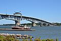
From West Point, the York River flows southeast. It empties into the Chesapeake Bay about 5 miles (8.0 km) (8 km) east of Yorktown. Yorktown is a historic town located on the southern side of the river. The U.S. Highway 17 crosses the river between Yorktown and Gloucester Point. This crossing is on a large bridge called the George P. Coleman Memorial Bridge.
A River Full of History
The York River has a long and interesting past. Native Americans used to call it the Pamunkey River. Later, in the 1600s, English colonists from the Virginia Company called it the Charles River.
Werowocomoco: An Ancient Capital
On the north side of the river, in what is now Gloucester County, was a very important place. This was Werowocomoco, one of the two main villages of the Powhatan Confederacy. Chief Powhatan, the powerful leader of many Native American tribes, lived here before the English arrived in 1609.
In 2002 and 2003, archaeologists found exciting evidence of a large, old settlement at Purtan Bay on the York River. After more digging, they believe this is very likely the site of Werowocomoco. They found signs of a big village that had been lived in since 1200 CE. They also found large earthworks, which are structures made of earth, built around 1400 CE. This was more than 200 years before the English colonists came! In 2006, the Werowocomoco Archeological Site was added to the National Register of Historic Places. Scientists from the College of William and Mary, the Virginia Department of Natural History, and Native American tribes are still working there.
Battles and Campaigns

The land between the York River and the James River to the south was very important in the American Revolutionary War. In October 1781, the British Army, led by General Cornwallis, was trapped at Yorktown. American forces, led by George Washington, surrounded them on land. At the same time, the French navy blocked them by sea. The Americans won the Battle of Yorktown, which forced Cornwallis to surrender. This victory helped end the war in the eastern United States.
During the American Civil War, this same area was again a battlefield. In 1862, it was part of the Peninsular Campaign.
Nature and Parks Along the River
York River State Park is a beautiful park located on the southern side of the river. It's northwest of Yorktown in James City County. There are also several large military bases on the south shore. These include Camp Peary and the Naval Weapons Station Yorktown (and Cheatham Annex) of the U.S. Navy.
Many areas along the river are protected wetlands and forests. These places are very important for migratory birds, especially waterfowl, that travel long distances. The Colonial Parkway, run by the National Park Service, offers a scenic drive through some of this natural area. It connects Williamsburg and Yorktown.
Crossing the York River

The only way to drive across the York River is on the George P. Coleman Memorial Bridge. This bridge is a special type called a drawbridge or swing bridge. It can open up to let tall ships pass through. The bridge carries U.S. Highway 17 between Yorktown and Gloucester Point.
The bridge was rebuilt and made bigger in the mid-1990s. There is a $2 toll to cross it by car, but you only pay if you are driving northbound. The bridge has also been used for a special program to help peregrine falcons. These birds are encouraged to nest on the bridge, helping their population grow in Virginia.
Images for kids
-
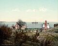
York River at Yorktown, ca. 1903
-
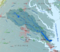
York River drainage basin
-
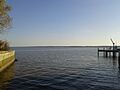
The confluence of the Mattaponi and Pamunkey Rivers in West Point, the site which marks the beginning of the York River
-
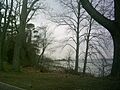
The banks of the York near Yorktown
-
The George P. Coleman Bridge
