Pamunkey River facts for kids
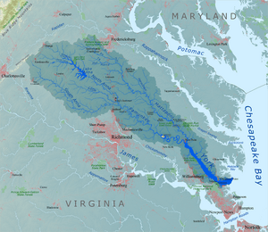
The Pamunkey River is a cool waterway, about 93 miles (150 km) long, in eastern Virginia, United States. It's like a major branch that flows into the York River. Together, these rivers are part of the huge Chesapeake Bay watershed, which means all the water from this area eventually flows into the Bay.
Where the Pamunkey River Flows
The Pamunkey River starts when two smaller rivers, the North Anna and South Anna rivers, join together. This meeting point is on the border of Hanover and Caroline counties, about 5 miles (8 km) northeast of a town called Ashland.
From there, the Pamunkey River generally flows southeast. It passes by the Pamunkey Indian Reservation, which is a special place for the Pamunkey people. The river continues its journey until it reaches the town of West Point. At West Point, the Pamunkey River meets another river called the Mattaponi River. When these two rivers combine, they form the larger York River.
The path of the Pamunkey River also helps define the borders of several counties. It forms parts of the southern edges of Caroline and King William counties. It also makes up parts of the northern edges of Hanover and New Kent counties.
Other Names for the Pamunkey River
Sometimes, rivers or places can have more than one name, especially over a long time. The official name, "Pamunkey River," was decided in 1892 by the United States Board on Geographic Names. This board helps make sure that places have clear, official names.
Before that, and sometimes even now, the Pamunkey River has been known by a few other names. These include:
- Pamauncke River
- Pamoeoncock River
- Pamunky River
- Pemaeoncock
- Yough-ta-mund
- Youghtanund
 | William L. Dawson |
 | W. E. B. Du Bois |
 | Harry Belafonte |


