
Caroline County, Virginia facts for kids
Quick facts for kids
Caroline County
|
|||
|---|---|---|---|

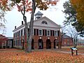
Caroline County Courthouse (built 1803–1809) in Bowling Green
|
|||
|
|||

Location within the U.S. state of Virginia
|
|||
 Virginia's location within the U.S. |
|||
| Country | |||
| State | |||
| Founded | 1727 | ||
| Named for | Caroline of Ansbach | ||
| Seat | Bowling Green | ||
| Largest town | Bowling Green | ||
| Area | |||
| • Total | 537 sq mi (1,390 km2) | ||
| • Land | 528 sq mi (1,370 km2) | ||
| • Water | 9 sq mi (20 km2) 1.7% | ||
| Population
(2020)
|
|||
| • Total | 30,887 | ||
| • Density | 57.52/sq mi (22.208/km2) | ||
| Time zone | UTC−5 (Eastern) | ||
| • Summer (DST) | UTC−4 (EDT) | ||
| Congressional district | 7th | ||


Caroline County is a county in the eastern part of Virginia. Its northern edge touches the Rappahannock River, especially near the old town of Port Royal. The main town and county seat is Bowling Green.
The county was created in 1728 and got its name from the British queen, Caroline of Ansbach. In the past, people grew a lot of tobacco and other crops here. This work was done by many generations of enslaved African Americans. Later, farming became less important.
In the 1900s, Caroline County became famous for its amazing horse farms. It's the birthplace of Secretariat, a super famous racehorse. Secretariat won the 1973 Triple Crown, which includes the Kentucky Derby, Preakness Stakes, and Belmont Stakes.
In 2020, about 30,887 people lived in Caroline County. The number of people living here has doubled in the last 50 years! Caroline County is now part of the bigger Greater Richmond Region.
Contents
History of Caroline County
How the County Started

Caroline County was formed in 1727 in the British Colony of Virginia. It was made from parts of Essex, King and Queen, and King William counties. It was named after Queen Caroline of Great Britain.
During the colonial times, Caroline County was where Thoroughbred horse racing began in North America. Special Arabian horses were brought from England to start breeding racehorses here. The economy relied on growing tobacco, which was a very important crop. Later, people grew different kinds of crops. Much of this work was done by enslaved Africans and African Americans.
Important leaders from Virginia wanted to be free from Great Britain. Edmund Pendleton, a patriot, helped Virginia decide to become independent in 1775. John Penn, who was from Caroline County, later signed the Declaration of Independence for North Carolina.
The 1800s
Explorers William Clark and his enslaved helper York were part of the famous Lewis and Clark Expedition (1803–1805). President Thomas Jefferson sent them to explore the new lands America bought west of the Mississippi River. William's older brother, General George Rogers Clark, was a hero from the Revolutionary War. Both brothers were born near what is now Ladysmith.
In 1847, William "Little Billy" Mahone started teaching in Caroline County. He later became a famous railroad builder, a general in the Confederate Army, and a United States Senator.
On May 10, 1863, Confederate General Thomas "Stonewall" Jackson died in Caroline County. His death happened at the Chandler plantation in Guinea Station. This house is now a museum called the "Jackson Shrine."
Near the end of the American Civil War, in April 1865, President Abraham Lincoln was killed in Washington, D.C. Federal troops tracked down John Wilkes Booth, Lincoln's killer, and his friend David E. Herold at Garrett's farm in Caroline County. Booth was shot and died during his capture. Herold was taken back to Washington and later executed.
The 1900s
Even though laws kept people of different races apart, many people in small towns were friends. In 1958, Richard Loving and Mildred Jeter decided to get married. They went to Washington, D.C., to marry, then came back to their home in Caroline County. Because they were an interracial couple, they were arrested under Virginia's laws against mixed-race marriages.
To avoid jail, they had to leave the state. But they wanted to come home, so they fought the law. Their case went all the way to the Supreme Court of the United States. In 1967, the Supreme Court decided that laws against mixed-race marriages were against the U.S. Constitution. This important case was called Loving v. Virginia.
At the southern end of the county, a farm called The Meadow became a top place for raising and training Thoroughbred racehorses. In 1972, Riva Ridge, a horse from The Meadow, won two big races: the Kentucky Derby and the Belmont Stakes. In 1973, Secretariat, who was born at The Meadow, won the Triple Crown for the Chenery family.
The 2000s
In 2003, the State Fair of Virginia bought Meadow Farm to be its new home. The annual Virginia State Fair had been held in Richmond, but it needed a bigger space.
Since September 2009, the Virginia State Fair has been held at the new Meadow Event Park in Caroline County. Other events, like the Meadow Celtic Games and Festival, are also held there.
In 2009, Caroline County won an "All-America City Award" from the National Civic League. This award recognizes communities that work together to solve problems.
Geography
Caroline County covers about 537 square miles. Most of this is land, and about 9 square miles is water. The county is about 30 miles north of Richmond (the capital) and 32 miles south of Fredericksburg.
Caroline County shares borders with several other counties:
- To the north: Spotsylvania and King George counties.
- To the south: Hanover County.
- To the east: King William, King and Queen, and Essex counties.
- To the west: Spotsylvania County.
The county has a quarry where scientists have found many ancient whale and shark skeletons. This is because the whole county was once under an ocean a very long time ago! A whale skeleton found here in 1990 was even a new type of whale never seen before.
Major roads like Interstate 95, US 1, and US 301 pass through Caroline County. These roads are important for traveling between different regions.
Nearby Counties
- King George County – north
- Hanover County – south
- King William County – east
- King and Queen County – east
- Essex County – east
- Spotsylvania County – northwest
Main Roads
 I-95: This is a major highway that runs north and south along the Eastern Seaboard. It has two exits in Caroline County.
 US 1: This road connects Richmond with other areas. It runs through several small communities in the county.
 US 17: This road connects the Hampton Roads area with Fredericksburg. It's also known as Tidewater Trail.
 US 301: This road connects Richmond with Baltimore, Maryland. It goes through Fort A.P. Hill and Port Royal.
 SR 2: This state road runs with US 301 for a bit and then becomes Main Street in Bowling Green.
 SR 30: This state road winds through the southern part of the county.
 SR 207: This major state road connects US 1 and I-95 to US 301. It's mostly known as Rogers Clark Boulevard.
Protected Areas
- Rappahannock River Valley National Wildlife Refuge (part of it is in Port Royal)
Population Facts
| Historical population | |||
|---|---|---|---|
| Census | Pop. | %± | |
| 1790 | 17,489 | — | |
| 1800 | 17,438 | −0.3% | |
| 1810 | 17,544 | 0.6% | |
| 1820 | 18,008 | 2.6% | |
| 1830 | 17,760 | −1.4% | |
| 1840 | 17,813 | 0.3% | |
| 1850 | 18,456 | 3.6% | |
| 1860 | 18,464 | 0.0% | |
| 1870 | 15,128 | −18.1% | |
| 1880 | 17,243 | 14.0% | |
| 1890 | 16,681 | −3.3% | |
| 1900 | 16,709 | 0.2% | |
| 1910 | 16,596 | −0.7% | |
| 1920 | 15,954 | −3.9% | |
| 1930 | 15,263 | −4.3% | |
| 1940 | 13,945 | −8.6% | |
| 1950 | 12,471 | −10.6% | |
| 1960 | 12,725 | 2.0% | |
| 1970 | 13,925 | 9.4% | |
| 1980 | 17,904 | 28.6% | |
| 1990 | 19,217 | 7.3% | |
| 2000 | 22,121 | 15.1% | |
| 2010 | 28,545 | 29.0% | |
| 2020 | 30,887 | 8.2% | |
| 2021 (est.) | 31,332 | 9.8% | |
| U.S. Decennial Census 1790–1960 1900–1990 1990–2000 2010 2020 |
|||
2020 Census Information
| Race / Ethnicity (NH = Non-Hispanic) | Pop 2010 | Pop 2020 | % 2010 | % 2020 |
|---|---|---|---|---|
| White alone (NH) | 18,145 | 18,841 | 63.57% | 61.00% |
| Black or African American alone (NH) | 8,297 | 7,627 | 29.07% | 24.69% |
| Native American or Alaska Native alone (NH) | 189 | 160 | 0.66% | 0.52% |
| Asian alone (NH) | 170 | 296 | 0.60% | 0.96% |
| Pacific Islander alone (NH) | 18 | 15 | 0.06% | 0.05% |
| Some Other Race alone (NH) | 49 | 163 | 0.17% | 0.53% |
| Mixed Race or Multi-Racial (NH) | 718 | 1,817 | 2.52% | 5.88% |
| Hispanic or Latino (any race) | 959 | 1,968 | 3.36% | 6.37% |
| Total | 28,545 | 30,887 | 100.00% | 100.00% |
Towns and Communities
Caroline County has two official towns:
Bowling Green
The town of Bowling Green was once called New Hope Village. An old road from Richmond to the Potomac River passed through here. A tavern was built before 1700, and the area became New Hope Village.
The town was renamed for "Bowling Green," a large farm owned by Colonel John Hoomes. He gave land when the town became the county seat in 1803. The farm was named after the Hoomes family's home in England. The Bowling Green farm was also one of the first places for horse racing in North America.
The Hoomes family's main house, built in 1741, is one of the oldest homes in Virginia that is still in its original condition. It is now a historic landmark.
The current Caroline County Court House was built in 1835. Bowling Green became an official town in 1837. It's known as the "cradle of American horse racing" and has one of the oldest Masonic Lodges in the country.
A railroad was built nearby in the 1830s. This railroad is still important today for moving goods and carrying Amtrak passenger trains.
Bowling Green is located along Virginia State Route 2. Later, U.S. Route 301 was built through the area. A new road, Virginia State Route 207, connects Bowling Green to Interstate 95 and U.S. Route 1.
In 1941, the U.S. government bought a large area of land north and east of Bowling Green. This became the A.P. Hill Military Reservation, now known as Fort A.P. Hill. It's named after a Virginia military hero, General Ambrose Powell Hill. Thousands of soldiers train here every year. It was also the site of the Boy Scouts of America's national Jamboree for many years.
Port Royal
Port Royal is a very old town. It was started in 1652 as a port on the Rappahannock River. Back then, rivers were the main way to travel and move goods in the British Colony of Virginia. It was a key place for shipping out tobacco.
People say Port Royal was named after the Roy family. Dorothy Roy and her husband John owned a warehouse, a ferry service across the Rappahannock River, and a tavern. Today, the chimneys of the Roy house are still standing in the town.
Port Royal became an official town in 1744. A special area in the town was set aside "for public and civic use" forever. This is where the Town Hall and firehouse are today.
Shipping from the port slowed down after railroads were built in the 1830s. The last passenger ship service ended in 1932. However, Port Royal is still served by major highways like U.S. Route 17 and U.S. Route 301.
Other Communities
Caroline County also has two other communities that are not official towns but are recognized by the census:
Education
Caroline County Public Schools provides public education for students in the county. In the 2020–2021 school year, there were 490 employees, including 209 teachers.
Famous People from Caroline County
- George Armistead: He was the commander of Fort McHenry during the Battle of Baltimore.
- John Wilkes Booth: A famous American actor who killed U.S. President Abraham Lincoln.
- Christopher Chenery: He helped start the New York Racing Association and owned Secretariat, the Triple Crown champion racehorse.
- William Clark: He was part of the Lewis and Clark Expedition. He and his enslaved helper, York, were born in Caroline County.
- General George Rogers Clark: A hero of the Revolutionary War. He conquered the old Northwest Territory (now the Midwest of the U.S.).
- Peter Durrett: He and his wife founded the First African Baptist Church in Lexington, Kentucky, which is one of the oldest Black Baptist churches in the U.S.
- George Fitzhugh: A lawyer and writer who supported slavery.
- Lex Luger: A record producer who owns a home in Milford, Virginia.
- Mildred and Richard Loving: They successfully fought against laws that made it illegal for people of different races to marry. Their story was made into the 2016 movie "Loving".
- Mi$tro: A rapper.
- Edmund Pendleton: A Virginia politician, lawyer, and judge who was active in the American Revolutionary War.
- John Taylor of Caroline: A politician and writer who served in the Virginia House of Delegates and the United States Senate.
- Thomas P. Westendorf: A notable composer.
- William Woodford: An officer in the French and Indian War and the American Revolutionary War.
Images for kids
-
Caroline County Courthouse (built 1803–1809) in Bowling Green
See also
 In Spanish: Condado de Caroline (Virginia) para niños
