
Rappahannock River facts for kids
Quick facts for kids Rappahannock River |
|
|---|---|

The Rappahannock at sunset
|
|
| Country | United States |
| State | Virginia |
| Counties | Lancaster, Middlesex, Essex, Richmond, Westmoreland, King George, Caroline, Stafford, Spotsylvania, Culpeper, Fauquier, Rappahannock |
| City | Fredericksburg |
| Physical characteristics | |
| Main source | Chester Gap 1,720 feet (520 m) |
| River mouth | Chesapeake Bay |
| Length | 195 miles (314 km) |
| Basin features | |
| Basin size | 2,848 sq mi (7,380 km2) |
The Rappahannock River is a river in eastern Virginia, United States. It is about 195 miles (314 km) long. The river flows across the northern part of Virginia. It starts in the Blue Ridge Mountains in the west. Then it goes through the Piedmont area. Finally, it reaches the Chesapeake Bay, south of the Potomac River.
The Rappahannock River drains an area of 2,848 square miles (7,376 km²). This is about 6% of all of Virginia. Most of the land around the river is rural and covered in forests. However, more buildings and towns have been built near the river in recent years. This is because it is close to the suburbs of Washington, D.C..

This river was very important in American history. Early settlements in the Virginia Colony were built along the Rappahannock. Later, it was a key location during the American Civil War. The river was a big challenge for armies moving by land. It often served as a dividing line between the "North" (the Union) and the "South" (the Confederate States of America).
Contents
The River's Story: A Look Back in Time

The name of the river comes from an Algonquian word. It was lappihanne, or toppehannock. This word means "river of quick, rising water" or "where the tide goes in and out." This was the name used by the local Rappahannock tribe.
Early small villages were along the lower Rappahannock during colonial times. But serious settlement of the river valley began in the early 1700s. Governor Alexander Spotswood encouraged people to move there. He wanted people to settle in a new river valley, not just the James River.
In 1714, Governor Spotswood looked for immigrants from Europe. He found people from Germany and Switzerland. They came to settle on land he owned where the Rappahannock and Rapidan rivers meet. These villages were called Germanna. They were started to find and use the iron ore in the area.
Battles on the River
A battle called the Battle of Rappahannock River happened here during the War of 1812. British boats with many marines and sailors captured four American privateer ships.
During the American Civil War, the river was a natural barrier. It had few easy places to cross (called fords) and even fewer bridges. This made it a strong defensive line. Troops behind the river felt safe from attacks from the other side.
It was very hard for Union troops to cross the river. They needed to cross it to move into southern Virginia. Control of the river changed many times during the war. Important battles fought along the river include the Battle of Fredericksburg. Another was the Battle of Rappahannock Station.
The Union army finally found a way around this river defense in 1864. This was during the Wilderness (or Overland) Campaign led by Ulysses S. Grant. This campaign eventually led to the Union victory. Some old documents from the 1700s and 1800s called the river "Hedgeman's River."
Where the River Flows
The Rappahannock River starts at Chester Gap. This is a wind gap in the Blue Ridge Mountains. It is a few miles southeast of Front Royal, Virginia. The river flows southeast. Then it is joined by the Rapidan River, its largest branch.
The Rappahannock then flows through the city of Fredericksburg. Southeast of Fredericksburg, the river gets wider and slower. It becomes a tidal estuary about 50 miles (80 km) long. An estuary is where fresh river water mixes with salty ocean water.
The river passes two small, historic towns: Port Royal and Port Conway. Port Royal is on the south bank, and Port Conway is on the north. Then it flows past Tappahannock on its southern bank. At this point, the river is more than a mile wide.
The last towns of any size before the river reaches the Chesapeake Bay are Irvington, Urbanna, Stingray Point, and White Stone Beach. The wide river enters the Chesapeake Bay about 20 miles (32 km) south of the Potomac River. It is also about 60 miles (97 km) east of Richmond, the state capital.
Where the river meets the bay, it is more than 3.5 miles (5.6 km) wide. This area, south of the Northern Neck peninsula, is a good place for catching oysters and crabs.
Fun on the River
Above Fredericksburg, the Rappahannock River is great for outdoor activities. You can enjoy canoeing and kayaking here. Most of the river's rapids are Class I and Class II, which are easy to moderate. However, near Remington, there are some rapids that are Class III, which are more challenging.
Parts of the river's watershed are protected. These areas are part of the Rappahannock River Valley National Wildlife Refuge. This helps keep the river and its surrounding nature healthy.
Images for kids
-
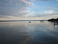
The Rappahannock at sunset
-
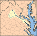
Rappahannock River watershed
-
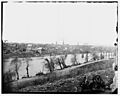
Fredericksburg, Virginia, March 1863. View from across the Rappahannock River.
See also
 In Spanish: Río Rappahannock para niños
