
Rappahannock County, Virginia facts for kids
Quick facts for kids
Rappahannock County
|
||
|---|---|---|

Rappahannock County Courthouse in Washington, Virginia
|
||
|
||

Location within the U.S. state of Virginia
|
||
 Virginia's location within the U.S. |
||
| Country | ||
| State | ||
| Founded | 1833 | |
| Named for | Rappahannock River | |
| Seat | Washington | |
| Largest town | Washington | |
| Area | ||
| • Total | 267 sq mi (690 km2) | |
| • Land | 266 sq mi (690 km2) | |
| • Water | 0.8 sq mi (2 km2) 0.3% | |
| Population
(2020)
|
||
| • Total | 7,348 | |
| • Density | 27.52/sq mi (10.626/km2) | |
| Time zone | UTC−5 (Eastern) | |
| • Summer (DST) | UTC−4 (EDT) | |
| Congressional district | 10th | |

Rappahannock County is a county in the northern part of Virginia, USA. It is right next to Shenandoah National Park. In 2020, about 7,348 people lived here. The main town, or county seat, is Washington.
The name "Rappahannock" comes from an old Algonquian word. It means "river of quick, rising water" or "where the tide goes in and out." The county is part of the larger Washington, D.C. area.
Contents
- History of Rappahannock County
- Historic Places and Buildings
- Geography of Rappahannock County
- People of Rappahannock County
- Land Use and Development
- Economy of Rappahannock County
- Education in Rappahannock County
- Communities in Rappahannock County
- Notable People from Rappahannock County
- Images for kids
- See also
History of Rappahannock County
Rappahannock County was officially started in 1833. People needed easier access to their county government. So, land was taken from Culpeper County to create this new county. It was named after the Rappahannock River, which forms one of its borders.
Early Land Ownership
In the early 1700s, a lot of this land belonged to Thomas Fairfax, the 6th Lord Fairfax. This huge area was called the Northern Neck Proprietary. It stretched between the Rappahannock and Potomac Rivers. The land was given to loyal supporters by King Charles II of England in 1649.
Lord Fairfax inherited this land in 1719. At first, people thought Rappahannock County was outside his land. But after a survey in 1735, it was confirmed that the county was part of his property.
Farming and Mills
After 1833, Rappahannock County was mainly a farming area. Farmers grew crops like wheat, oats, corn, and hay. They also raised cattle, sheep, and pigs. The county had many streams and rivers. Mills were built along these waterways to grind grain and saw lumber.
In the 1850s, new roads called turnpikes were built. These helped people travel and transport goods. Most people traveled by walking, riding horses, or using horse-drawn wagons.
The Civil War and Recovery
Virginia left the Union in 1861, leading to the Civil War. No major battles happened in Rappahannock County. However, soldiers often moved through the area. Men from the county fought in various Virginia regiments.
The war badly damaged the county's farms and roads. After the war, the county slowly recovered. In 1870, a new government system was set up. The county was divided into five areas, each with an elected supervisor. This system is still used today.
By the 1890s, things were getting better. Apples became an important crop. In the 1900s, new things like telephones, electricity, and cars arrived. Roads improved, and high schools were built.
Shenandoah National Park's Impact
In the 1920s, the state began buying land for Shenandoah National Park. About 32,000 acres in Rappahannock County became part of the park. Many families had to move. A memorial now lists the names of those families.
During the 1930s Great Depression, the county got help from government programs. Workers built Skyline Drive in the park. This created jobs and a market for local farmers.
The park also brought many tourists. More gas stations, restaurants, and motels opened. In the 1970s, more people moved to the county. They were looking for a quiet, rural life. These new residents, including artists and craftspeople, mixed with the long-time locals. Today, the county still welcomes tourists with shops and restaurants. It remains mostly rural due to rules about land use.
Historic Places and Buildings
Rappahannock County has five historic areas listed on the National Register of Historic Places. These are in Ben Venue, Flint Hill, Laurel Mills, Sperryville, and Washington. There are also thirteen other historic buildings listed. Many other old homes and buildings from the 1800s can be found. Over 300 family cemeteries have also been recorded as historic sites.
Geography of Rappahannock County
Rappahannock County covers about 267 square miles. Most of this (266 square miles) is land, with a small amount of water. The Rappahannock River forms the county's northeastern border. The Blue Ridge Mountains are in the western part of the county.
Neighboring Counties
- Warren County, Virginia – to the northwest
- Fauquier County, Virginia – to the northeast
- Culpeper County, Virginia – to the southeast
- Madison County, Virginia – to the southwest
- Page County, Virginia – to the west
Protected Natural Areas
- Shenandoah National Park (part of it is in the county)
Mountains in Rappahannock County
Rappahannock County is in the northern Piedmont area of Virginia. It has many small mountains, often named after the families who first owned the land. These mountains lead up to the Blue Ridge Mountains in Shenandoah National Park.
Years ago, much of the land on these mountains was cleared for farms. Today, they are covered in trees again. They have hiking trails, including the Appalachian Trail. Skyline Drive runs along the tops of the Blue Ridge Mountains.
Here are some of the mountains in Rappahannock County:
- Battle and Little Battle Mountains
- Big and Little Bastard Mountains
- Bessie Bell Mountain
- Browns Mountain
- Buck Ridge
- Butler Mountain
- Castle (Castleton) Mountain
- Catlett Mountain
- Chancellor Mountain
- Compton Peak
- Fielding Mountain
- Fodderstack Mountain
- Fogg Mountain
- Fork Mountain
- Ginger Hill
- Googe Mountain
- Grindstone Mountain
- Hazel Mountain
- Hickerson Mountain
- Hogback Mountain
- Hot Mountain
- Jefferson Mountain
- Jenkins and Little Jenkins Mountains
- Jobbers Mountain
- Keyser Mountain
- Long Mountain
- Mary's Rock
- Mason and Little Mason Mountains
- Massies Mountain
- Meetinghouse Mountain
- Menefee Mountain
- Mulky and Little Mulky Mountains
- North Marshall Mountain
- Long Mountain
- Oventop Mountain
- Pass Mountain
- The Peak
- Pickerel Ridge
- Pignut Mountain
- Pine Hill
- Piney Ridge
- The Pinnacle
- Poes Mountain
- Poortown Mountain
- Redmans Mountain
- Red Oak Mountain
- Rosser Mountain
- Round Mountain
- Schoolhouse Mountain
- Skinner Ridge
- Slaughter Mountain
- Turkey Ridge
- Turkey Mountain
- Walden Mountain
- Wolf Mountain
_from_the_overpass_for_Virginia_State_Route_48_(Skyline_Drive)_at_Thornton_Gap_within_Shenandoah_National_Park_on_the_border_of_Page_and_Rappahannock_Counties_in_Virginia.jpg)
Transportation in Rappahannock County
Three main highways cross the county: U.S. Route 211, U.S. Route 522, and State Route 231. These roads make up about 21% of all public roads. The other roads are smaller and connect to farms and homes.
Five roads in the county are called Virginia Scenic Byways. Skyline Drive in Shenandoah National Park is a National Scenic Byway. The county does not have public transportation like airports, bus stations, or train stations.
 US 211
 US 522
 SR 231
- Skyline Drive
People of Rappahannock County
| Historical population | |||
|---|---|---|---|
| Census | Pop. | %± | |
| 1840 | 9,257 | — | |
| 1850 | 9,782 | 5.7% | |
| 1860 | 8,850 | −9.5% | |
| 1870 | 8,261 | −6.7% | |
| 1880 | 9,291 | 12.5% | |
| 1890 | 8,678 | −6.6% | |
| 1900 | 8,843 | 1.9% | |
| 1910 | 8,044 | −9.0% | |
| 1920 | 8,070 | 0.3% | |
| 1930 | 7,717 | −4.4% | |
| 1940 | 7,208 | −6.6% | |
| 1950 | 6,112 | −15.2% | |
| 1960 | 5,368 | −12.2% | |
| 1970 | 5,199 | −3.1% | |
| 1980 | 6,093 | 17.2% | |
| 1990 | 6,622 | 8.7% | |
| 2000 | 6,983 | 5.5% | |
| 2010 | 7,373 | 5.6% | |
| 2020 | 7,348 | −0.3% | |
| U.S. Decennial Census 1790–1960 1900–1990 1990–2000 2010 2020 |
|||
The county's population went down from 1840 to 1970. This was partly because many freed slaves moved north. Also, fewer people were needed to work on farms. Since then, the population has slowly grown.
In 2019, about 16% of people were 17 or younger. About 28% were 65 or older. Rappahannock residents are older than the average for the U.S. The county has few people per square mile, only about 27.9 people.
Most homes in the county are single-family houses. The number of homes has more than doubled since 1960. Many homes are lived in all year, but some are used only seasonally.
The county has been settled by three groups of people. First, those whose families have lived there for many generations. Second, young adults who started moving there in the 1960s and 70s. Third, retirees and people who visit on weekends and then decide to stay. People from all income levels live together. They all seem to love the county's beauty, quiet, farms, clean rivers, and dark night skies.
Land Use and Development
Rappahannock County is mostly covered by forests (73.7%). About 20.1% is farmland and pastures. The rest is roads and buildings. The main type of forest is oak-hickory.
A Virginia law helps protect the county's rural feel. It allows tax breaks for land used for farming or forests. This helps landowners keep their large farms and forests instead of selling them off. About half of the county's land gets this tax break.
Many landowners have also placed their land in "conservation easements." This means they agree to protect the land from development. This helps keep the landscape natural and protects water and scenic views. About 52.2 square miles are protected this way. Another 49.5 square miles are in Shenandoah National Park. This means a large part of the county is protected from too much building.

The county has a long history of planning to limit development. This helps keep its rural, natural beauty. For example, there's a rule that land outside villages must be at least 25 acres to be built on. Many residents believe these rules have kept the county from becoming too crowded. They feel it's a "rural oasis" compared to other fast-growing areas.
Economy of Rappahannock County
In the past, the county's economy was all about farming. But farming has changed a lot. The number of farms went down a lot between 1949 and 1974. However, it has slowly started to increase again. Most farms are family-owned. Some farmers lease land from owners who want their pastures kept up.
Hay is the main crop, and beef cattle are common. Apple and peach orchards used to be big, but now there are only a few small ones. Vineyards are growing in popularity. Wineries, organic farms, and grass-fed beef have created new chances for farmers. Some farmers sell their products in cities like Washington D.C. The county has nine award-winning wineries, two distilleries, two breweries, and a cider and mead place.
Farming no longer employs as many people as it used to. In 2010, only 7% of workers were in farming. Most people worked in health/education, construction, or office jobs. About 19% of residents were 65 or older and mostly retired.
The average family income in 2010 was $75,975. Rappahannock County is one of the wealthiest counties in Virginia. However, a lot of the wealth is held by a few people. About 10% of families in the county live below the poverty line.
There are no large businesses, supermarkets, or big stores in the county. This means the county relies on property taxes from homeowners to fund its budget. Residents often have to drive outside the county to shop. A big issue for residents is the lack of good cell phone and internet service. This is mainly available along the main highways.
Education in Rappahannock County
In the 1800s, education was mostly through private schools. Public schools became mandatory around 1869-1870. This led to 14 schools for white students and 7 for black students. High schools for white students opened in Washington and Sperryville in 1908-1909. Black students had to travel outside the county for high school.
In 2017-2018, Rappahannock County Public Schools had about 812 students. They attended one elementary school and one high school. The graduation rate was high, at 94%. Most graduates (80%) continued their education.
The county pays a large share of its education costs from local taxes (80%). The state contributes only 20%. This is different from other parts of Virginia, where the state usually pays more. This is because the county has no large businesses to tax.
There are also four private schools in the county. These include Wakefield Country Day School, Hearthstone School, Belle Meade Montessori School, and the Child Care and Learning Center. About 60 children in the county are homeschooled.
The Rapp Center for Education offers classes for adults. They teach things like healthcare training and computer skills.
Communities in Rappahannock County

Rappahannock County has one official town, Washington. It also has five villages: Chester Gap, Flint Hill, Amissville, Sperryville, and Woodville. These villages don't have exact borders. They usually have a post office, a general store, older homes, churches, and small shops.
Town
Census-designated places
Other Unincorporated Communities
- Amissville
- Boston
- Castleton
- Huntly
- Laurel Mills
- Peola Mills
- Revercombs Corner
- Wakefield Manor
- Woodville
Community Facilities and Activities
Rappahannock County has no stoplights, large stores, or fast-food chains. It also doesn't have sprawling housing developments.
The county has one public library. In 2020, many people used the library's WiFi. This shows how hard it is to get internet service in the county.
From space, Rappahannock County looks like one of the few dark spots on the East Coast. It's one of the last places where you can see the Milky Way clearly. In 2019, the Rappahannock County Park became an International Dark-Sky Park. This means it's a great place to watch the stars. The park holds events to view the night sky.
The county has seven volunteer fire and rescue companies. They handle fire and ambulance calls. The Rappahannock News is the local weekly newspaper. The town of Washington is home to The Inn at Little Washington, a very famous restaurant. There are also 35 churches and two medical facilities. The Rappahannock Historical Society helps people learn about the county's history.
The Rappahannock Association for the Arts and the Community supports local artists. There are three performing arts theaters. The nationally known Kid Pan Alley, which helps kids write songs, started here. Rappahannock Radio interviews local people.
Other fun things to do include a golf course and various annual events. These include the Fodderstack 10K race, Sperryfest (with a rubber duck race!), Oktoberfest, and the Rappahannock Farm Tour. There are also art studio tours, horse races, a carnival, a bike ride, and a blues festival. The county celebrates the Fourth of July and Christmas with parades and fireworks.
For outdoor fun, you can go fishing, horseback riding, camping, hiking, and canoeing. Many of these activities are in Shenandoah National Park. There are also walking trails along the Thornton River. Foxhunting is popular, and people also hunt deer and bears.
The county is a popular place for tourists. There's a system of 31 markers about the Civil War throughout the county.
Notable People from Rappahannock County
- Charles T. "Chuck" Akre – a well-known investor
- Ned Bittinger – a portrait painter
- Edward Dolnick – an author
- Frederick Hart – an American sculptor
- Ben Jones – an actor (played Cooter on The Dukes of Hazzard) and former politician
- James Kilpatrick – a former newspaper columnist
- Lorin Maazel – a famous orchestra director
- Ronald F. Maxwell – a film director known for Civil War movies
- Eugene McCarthy – a former Senator
- Patrick O’Connell – the chef and owner of The Inn at Little Washington
- Mary Virginia Proctor – a journalist and activist
- John Fox Sullivan – a former publisher and mayor of Washington, Virginia
Images for kids
-
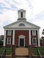
Rappahannock County Courthouse in Washington, Virginia
-
Rappahannock County Seal
-
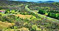
Aerial view of part of Rappahannock County, Virginia
See also
 In Spanish: Condado de Rappahannock para niños
