Chester Gap, Virginia facts for kids
Quick facts for kids
Chester Gap, Virginia
|
|
|---|---|
|
Census-designated place (CDP)
|
|

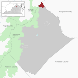
Location of the Chester Gap CDP within Rappahannock County
|
|
| Country | United States |
| State | Virginia |
| County | Rappahannock |
| Elevation | 1,526 ft (465 m) |
| Population | |
| • Total | 894 |
| Time zone | UTC-5 (Eastern (EST)) |
| • Summer (DST) | UTC-4 (EDT) |
| ZIP code |
22623, 22640
|
| Area code(s) | 540 |
| FIPS code | 51-16240 |
| GNIS feature ID | 2630625 |
Chester Gap is a small community located in the state of Virginia, United States. It's a special type of place called a census-designated place (CDP). This means it's an area that the government counts for population statistics, but it's not officially a city or town with its own local government.
Chester Gap is unique because it sits across two different counties: Rappahannock County and Warren County. As of the 2020 Census, about 894 people live there. The community gets its name from the natural feature it's built around, which is also called Chester Gap.
What is Chester Gap?
Chester Gap is a natural low point or pass in a mountain ridge. These types of passes are often called "wind gaps" because they can be formed by strong winds or by water erosion over many years. This gap makes it easier to travel through the mountains.
Where is Chester Gap Located?
Chester Gap is found in the northern part of Virginia. It's nestled in the Blue Ridge Mountains, which are part of the larger Appalachian Mountains range. Being in a mountain gap means it has interesting geography and often beautiful views.
Population and Community
The population of Chester Gap was 839 people in 2010, and it grew slightly to 894 by 2020. Even though it's not a formal town, it's a recognized community where people live and work. The area is known for its natural beauty and quiet lifestyle.
See also
 In Spanish: Chester Gap (Virginia) para niños
 | Ernest Everett Just |
 | Mary Jackson |
 | Emmett Chappelle |
 | Marie Maynard Daly |


