Lancaster County, Virginia facts for kids
Quick facts for kids
Lancaster County
|
|
|---|---|

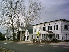
Central Lancaster, the county seat, with the county courthouse visible
|
|

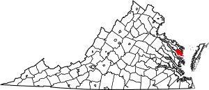
Location within the U.S. state of Virginia
|
|
 Virginia's location within the U.S. |
|
| Country | |
| State | |
| Founded | 1651 |
| Seat | Lancaster |
| Largest town | Kilmarnock |
| Area | |
| • Total | 231 sq mi (600 km2) |
| • Land | 133 sq mi (340 km2) |
| • Water | 98 sq mi (250 km2) 42.4% |
| Population
(2020)
|
|
| • Total | 10,919 |
| • Density | 47.27/sq mi (18.25/km2) |
| Time zone | UTC−5 (Eastern) |
| • Summer (DST) | UTC−4 (EDT) |
| Congressional district | 1st |
Lancaster County is a cool place in Virginia, right on a peninsula called the Northern Neck. It's a type of local government area called a county.
In 2020, about 10,919 people lived here. The main town, or county seat, is called Lancaster.
Lancaster County is near where the Rappahannock River meets the Chesapeake Bay. This area is also known for growing grapes and making wine! It's the busiest county on the Northern Neck. The biggest town is Kilmarnock, Virginia.
Contents
A Look Back: History of Lancaster County

Lancaster County was created in 1651. It was formed from parts of Northumberland and York counties.
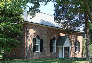
A very important person named Robert "King" Carter lived here in the 1700s. You can still see buildings from his time, like Christ Church and St. Mary's, Whitechapel.
Other cool historic places you can visit include the Lancaster Courthouse Historic District. This area has the Mary Ball Washington Museum and Library. You can also explore Belle Isle State Park and the Village of Morattico Historic District.
Exploring the Land: Geography of Lancaster County
Lancaster County covers about 231 square miles (598 square kilometers). A big part of it is water, about 98 square miles (254 square kilometers). The land area is about 133 square miles (344 square kilometers).
Neighboring Counties
Lancaster County shares its borders with a few other counties:
- Richmond County to the northwest
- Northumberland County to the north
- Middlesex County to the south and southwest
Main Roads and Highways
These are the major roads that help people get around Lancaster County:
 SR 3
SR 3 SR 200
 SR 201
 SR 222
 SR 354
Who Lives Here: Population Changes
The number of people living in Lancaster County has changed over many years. Here's a quick look at how the population has grown and shrunk:
| Historical population | |||
|---|---|---|---|
| Census | Pop. | %± | |
| 1790 | 5,638 | — | |
| 1800 | 5,375 | −4.7% | |
| 1810 | 5,592 | 4.0% | |
| 1820 | 5,517 | −1.3% | |
| 1830 | 4,801 | −13.0% | |
| 1840 | 4,628 | −3.6% | |
| 1850 | 4,708 | 1.7% | |
| 1860 | 5,151 | 9.4% | |
| 1870 | 5,355 | 4.0% | |
| 1880 | 6,160 | 15.0% | |
| 1890 | 7,191 | 16.7% | |
| 1900 | 8,949 | 24.4% | |
| 1910 | 9,752 | 9.0% | |
| 1920 | 9,757 | 0.1% | |
| 1930 | 8,896 | −8.8% | |
| 1940 | 8,786 | −1.2% | |
| 1950 | 8,640 | −1.7% | |
| 1960 | 9,174 | 6.2% | |
| 1970 | 9,126 | −0.5% | |
| 1980 | 10,129 | 11.0% | |
| 1990 | 10,896 | 7.6% | |
| 2000 | 11,567 | 6.2% | |
| 2010 | 11,391 | −1.5% | |
| 2020 | 10,919 | −4.1% | |
| U.S. Decennial Census 1790–1960 1900–1990 1990–2000 2010 2020 |
|||
Towns and Communities
Lancaster County has several towns and smaller communities.
Towns
- Irvington
- Kilmarnock - part of this town is also in Northumberland County
- White Stone
Census-Designated Places
These are areas that are like towns but aren't officially incorporated as one:
Other Small Communities

Fun Things to See and Do
Lancaster County has many interesting places to visit. The historic church of St. Mary's, Whitechapel was founded way back in 1669. Did you know that Mary Ball Washington, who was the mother of George Washington, was born in this church's area?
Rappahannock General Hospital is located in Kilmarnock. It's the only hospital on the Northern Neck.
Other cool attractions include:
- Irvington Steamboat Museum
- Windmill Point Beach
- Belle Isle State Park
- Chilton Woods State Forest
- Ampro Shipyard
- Historic Christ Church
See also
 In Spanish: Condado de Lancaster (Virginia) para niños
 | Shirley Ann Jackson |
 | Garett Morgan |
 | J. Ernest Wilkins Jr. |
 | Elijah McCoy |

