
York County, Virginia facts for kids
Quick facts for kids
York County
|
||
|---|---|---|

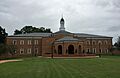
York County Courthouse
|
||
|
||

Location within the U.S. state of Virginia
|
||
 Virginia's location within the U.S. |
||
| Country | ||
| State | ||
| Founded | 1634 | |
| Named for | York | |
| Seat | Yorktown | |
| Largest community | Grafton | |
| Area | ||
| • Total | 215 sq mi (560 km2) | |
| • Land | 105 sq mi (270 km2) | |
| • Water | 110 sq mi (300 km2) 51.3% | |
| Population | ||
| • Total | 70,045 | |
| • Density | 325.8/sq mi (125.79/km2) | |
| Time zone | UTC−5 (Eastern) | |
| • Summer (DST) | UTC−4 (EDT) | |
| Congressional district | 1st | |

York County is a special area in eastern Virginia. It's located in a region called the Tidewater, which is near the coast. In 2020, about 70,045 people lived here. The main town and center of the county is Yorktown.
York County is on the northern side of the Virginia Peninsula. The York River forms its northern border. It's part of a larger area that includes cities like Virginia Beach, Norfolk, and Newport News. Many small rivers and streams that flow into the York River are found here. York County shares land with cities like Williamsburg and Newport News. It also borders James City County and Gloucester County across the York River.
York County is one of the oldest counties in the United States! It was first created in 1634 as Charles River Shire. It was renamed York County in 1643. Yorktown, in York County, is a very important historical place. It's one of the three points of the "Historic Triangle of Colonial Virginia". This is where the last major battle of the American Revolutionary War happened in 1781. The British forces surrendered here, and the United States became an independent country.
Today, York County has several important U.S. military bases. It also has beautiful waterfront areas for homes and fun activities. You can find parts of Busch Gardens Williamsburg theme park and Water Country USA water park here. The Yorktown Battlefield and the American Revolution Museum at Yorktown are also in the county. A beautiful road called the Colonial Parkway connects Yorktown to Colonial Williamsburg and Jamestown. Many people from all over the world visit these historical sites, which helps the local economy.
Contents
Exploring York County's Past
Native American History
Long ago, the area that is now York County was home to many Native American groups. These groups were hunter-gatherers who lived here for thousands of years.
By the late 1500s, much of the coastal area of Virginia was called Tenakomakah. This Algonquian word means "densely inhabited land." The tribes living here spoke languages from the Algonquian family.
A powerful chief named Wahunsunacock (also known as Powhatan) led many of these tribes. He created a large group called the Powhatan Confederacy. Chief Powhatan had a main village called Werowocomoco, which was located along the north side of the York River in what is now Gloucester County.
The Chiskiack tribe, part of the Powhatan Confederacy, lived in York County along the York River until the 1630s. They moved away because of conflicts with the growing English colony at Jamestown. The English later built a settlement near the Chiskiack village. Today, parts of this area are within the Naval Weapons Station Yorktown.
Early European Settlements
In 1570, Spanish Jesuit priests tried to start a mission here called the Ajacán Mission. They had a Native American guide named Don Luis. However, Don Luis soon left them, and in 1571, he led an attack that killed most of the Spanish group. The Spanish did not try to build another mission in this area.
About 30 years later, English colonists arrived and started Jamestown in 1607. In 1634, the area that is now York County was officially formed as Charles River Shire. It was named after King Charles I of England. This makes York County one of the oldest counties in the United States! In 1643, Charles River County and the Charles River were renamed York County and York River. Many believe they were named after the city of York in England.
The Town of Yorktown

The first courthouse and jail in the county were built near what is now Yorktown. The community was first a port for shipping tobacco to Europe. It was called by different names like Port of York or Town of York. In 1691, it officially became Yorktown. Even though it was never formally made a city, Yorktown is the main town of York County. The only town that used to be part of York County and became its own city was Poquoson in 1975.
Yorktown is most famous for being the place where General Cornwallis surrendered to General George Washington in 1781. This battle ended the American Revolutionary War. Yorktown was also important during the American Civil War in 1862.
Changes to York County's Borders
Over the years, some small towns in York County were taken over by the U.S. government for military bases. For example, the town of Lackey became part of the Naval Weapons Station Yorktown during World War I. Many African American landowners who lived there had to move. They were often relocated to Grove, near the border of York and James counties.
During World War II, other towns like Penniman, Magruder, and Bigler's Mill became part of military areas like Cheatham Annex and Camp Peary. Many people from these towns also moved to Grove.
In 1975, the town of Poquoson, which was part of York County, became its own independent city. Even so, York County and Poquoson still work together on things like courts and the sheriff's office.
York County Today
Since the 1980s, York County has changed a lot. It used to be mostly farms and open land. Now, it's a popular place for people who work in nearby cities like Hampton and Newport News to live.
Today, York County and Yorktown are key parts of the Historic Triangle of Colonial Virginia. This area includes Yorktown, Jamestown, and Williamsburg. The beautiful Colonial Parkway connects these three historical sites. In 2005, York County finished building Riverwalk Landing in Yorktown. This area has shops and restaurants along the waterfront, making the town even more appealing to visitors.
Geography and Landscape

York County covers about 215 square miles. About 105 square miles of this is land, and 110 square miles (51.3%) is water. It's one of the smaller counties in Virginia by land area. It's located very close to the mouth of the Chesapeake Bay.
The county has two main populated areas. A large area of federal land, including military bases and wooded parks, divides the county in the middle. The southern part of the county has many suburban neighborhoods and most of the people live there. This area is quite developed. There's also a power plant and a petroleum terminal along the York River near Yorktown.
The northern part of the county is more connected to the Williamsburg area. While it has fewer people than the south, it's also growing with new homes and shopping centers.
Neighboring Areas
York County shares borders with:
- Gloucester County, Virginia (to the north)
- Mathews County, Virginia (to the northeast)
- Northampton County, Virginia (to the east)
- Poquoson, Virginia (to the southeast)
- Hampton, Virginia (to the south)
- Newport News, Virginia (to the southwest)
- James City County, Virginia (to the west)
- Williamsburg, Virginia (to the west)
Protected Natural Areas
- Colonial National Historical Park (part of it is in York County)
Population and People
York County has grown quite a bit over the years. In 1790, about 5,233 people lived here. By 2020, the population had reached 70,045.
Who Lives in York County?
According to the 2020 census, here's a look at the people living in York County:
- About 67% of the people are White (not Hispanic).
- About 12.3% are Black or African American (not Hispanic).
- About 6.1% are Asian (not Hispanic).
- About 6.3% are of two or more races (not Hispanic).
- About 7.3% of the population is Hispanic or Latino (they can be of any race).
In 2010, the average household income in York County was $84,167. This was the highest in the Hampton Roads area.
Getting Around York County
Public Transportation
York County has public transportation services. The Williamsburg Area Transit Authority (WATA) buses serve the northwestern part of the county near Williamsburg. Hampton Roads Transit (HRT) buses run close to the southeastern part of the county. Yorktown also has a free trolley bus that takes visitors around the town.
There isn't a train station in York County. The closest train stations are in Williamsburg and Newport News. You can also find Greyhound bus services in these cities.
A part of the Newport News/Williamsburg International Airport is located in York County. This is the only regional airport on the southern part of the peninsula. Other big airports nearby are Norfolk International Airport and Richmond International Airport.
Major Roads
The main highway in York County is Interstate 64. U.S. Route 17 crosses the York River using the Coleman Memorial Bridge, connecting York County to Gloucester County. State Route 199 goes around Williamsburg and connects to Interstate 64 near Water Country USA. Other important roads include U.S. Route 60, Virginia State Route 134, and Victory Boulevard.
Communities in York County
Main Communities
Other Neighborhoods
Schools in York County
York County has many schools for students of all ages.
Elementary Schools
- Bethel Manor ES
- Coventry ES
- Dare ES
- Grafton Bethel ES
- Magruder ES
- Mt. Vernon ES
- Seaford ES
- Tabb ES
- Waller Mill ES
- Yorktown ES
- Extend Center (Dare Elementary)
Middle Schools
- Grafton MS (connected to Grafton High School)
- Queens Lake MS
- Tabb MS
- Yorktown MS
High Schools
- Bruton HS
- Grafton HS (connected to Grafton Middle School)
- Tabb HS
- York HS
- York River Academy
- Virtual High School
Military Bases in York County
York County is home to several large and important military bases for the United States. These bases are located along the York River.
- The Coast Guard Training Center Yorktown is here.
- The Naval Weapons Station Yorktown was created during World War I. It now includes the Cheatham Annex Supply Complex.
- Camp Peary was built during World War II as a training base for the Seabees (Navy construction battalions). During the war, it was used to hold important prisoners of war.
These large military areas have led to the relocation of some smaller towns over the years.
Images for kids
-
York County Courthouse
See also
 In Spanish: Condado de York (Virginia) para niños
