
Poquoson, Virginia facts for kids
Quick facts for kids
Poquoson, Virginia
|
||
|---|---|---|

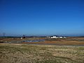
Boats parked at the Poquoson Marina. Boating has been an important part of Poquoson's economy since its inception.
|
||
|
||
| Nickname(s):
Bull Island
|
||
| Country | ||
| State | ||
| County | None (Independent city) | |
| Founded | 1631 | |
| Area | ||
| • Independent city | 78.46 sq mi (203.20 km2) | |
| • Land | 15.36 sq mi (39.77 km2) | |
| • Water | 63.10 sq mi (163.43 km2) | |
| Elevation | 10 ft (3 m) | |
| Population
(2020)
|
||
| • Independent city | 12,460 | |
| • Density | 811.20/sq mi (313.21/km2) | |
| • Metro | 1,799,674 | |
| Time zone | UTC−5 (EST) | |
| • Summer (DST) | UTC−4 (EDT) | |
| ZIP code |
23662
|
|
| Area code(s) | 757, 948 | |
| FIPS code | 51-63768 | |
| GNIS feature ID | 1479363 | |
| Website | http://www.poquoson-va.gov | |

Poquoson (/pəˈkoʊsən/) is a city in Virginia, United States. It is often called Bull Island. As of 2020, about 12,460 people live there. Poquoson is special because it is an "independent city." This means it is not part of any county.
Poquoson is located on the Virginia Peninsula. This area is part of the larger Hampton Roads region. It is one of the oldest cities in Virginia that still has its original name. This name comes from the Native Americans who lived there long ago.
Contents
History of Poquoson
The name "Poquoson" comes from a Native American word. It means "great marsh." The word pocosin described a low, wet, woody area. It would be covered by water in winter but dry in summer. The Native Americans here were Algonquians, part of the Powhatan Confederacy.
English colonists began settling this area in the early 1600s. The first mention of Poquoson was in 1631. This was when a land grant was given to Christopher Calthorpe. The area was first called New Poquoson Parish.
In 1634, Virginia was divided into eight shires (like counties). Poquoson was in Charles River Shire. This name changed to York County in 1642. Poquoson remained a small farming community for many years.
Poquoson in Major Wars
During the American Revolutionary War, independence was won nearby at Yorktown. This is now a popular tourist spot.
The American Civil War also affected Poquoson. The Battle of Big Bethel was fought nearby in 1861. In 1862, Union General George B. McClellan planned to march up the peninsula to capture Richmond. Confederate forces built defenses, including one near the Poquoson River. After the Confederates left, the Union Army used Ship Point as a supply base.
Becoming a City
Poquoson became an official town in 1952. Citizens wanted to keep their own high school. They did not want their children to be bused to York High School. In 1975, Poquoson became an independent city. This helped it stay separate from the nearby city of Hampton. Even today, Poquoson shares some services, like courts and the jail, with York County.
Why "Bull Island"?
Poquoson has been called "Bull Island" for a long time. For centuries, farmers let their cattle roam freely in the salt marshes. Even though there are few farms left, people from Poquoson still call themselves "Bull Islanders."
Media and News
Poquoson has several ways to get news and entertainment.
Newspapers and Magazines
The main daily newspaper for Poquoson is the Daily Press. Other papers include the New Journal and Guide and The Virginian-Pilot. There is also a weekly paper called The Yorktown Crier / The Poquoson Post. Hampton Roads Magazine is a bi-monthly magazine for the area.
Television and Radio
Poquoson is served by many radio stations. It also has several television stations. These include channels like WTKR-TV (CBS), WAVY (NBC), and WVEC-TV (ABC). Cable TV, satellite TV, and fiber optic TV services are also available.
Geography and Climate
Poquoson is located at 37°7′59″N 76°22′25″W / 37.13306°N 76.37361°W.
Land and Water
The city covers about 78 square miles. Most of this area, about 63 square miles, is water. Only about 15 square miles is land. Poquoson is a peninsula. It is surrounded by the Poquoson River, Back River, and the Chesapeake Bay. York County is to the west.
Weather in Poquoson
Poquoson has four seasons. This means you can enjoy outdoor activities all year. The average yearly temperature is about 60°F (16°C). It gets about 6 inches (15 cm) of snow and 47 inches (119 cm) of rain each year. Summers are hot and humid.
| Climate data for Norfolk International Airport, Virginia (1981–2010 normals, extremes 1874–present ) | |||||||||||||
|---|---|---|---|---|---|---|---|---|---|---|---|---|---|
| Month | Jan | Feb | Mar | Apr | May | Jun | Jul | Aug | Sep | Oct | Nov | Dec | Year |
| Record high °F (°C) | 84 (29) |
82 (28) |
92 (33) |
97 (36) |
100 (38) |
102 (39) |
105 (41) |
105 (41) |
100 (38) |
95 (35) |
86 (30) |
82 (28) |
105 (41) |
| Mean maximum °F (°C) | 71.1 (21.7) |
73.2 (22.9) |
80.2 (26.8) |
86.4 (30.2) |
91.4 (33.0) |
95.5 (35.3) |
97.8 (36.6) |
95.8 (35.4) |
92.1 (33.4) |
85.6 (29.8) |
78.7 (25.9) |
72.5 (22.5) |
98.8 (37.1) |
| Mean daily maximum °F (°C) | 48.1 (8.9) |
50.9 (10.5) |
58.2 (14.6) |
67.6 (19.8) |
75.4 (24.1) |
83.5 (28.6) |
87.4 (30.8) |
85.1 (29.5) |
79.3 (26.3) |
70.1 (21.2) |
61.1 (16.2) |
52.1 (11.2) |
68.3 (20.2) |
| Mean daily minimum °F (°C) | 32.7 (0.4) |
34.4 (1.3) |
40.5 (4.7) |
48.9 (9.4) |
57.9 (14.4) |
67.1 (19.5) |
71.9 (22.2) |
70.7 (21.5) |
65.3 (18.5) |
54.0 (12.2) |
44.6 (7.0) |
36.1 (2.3) |
52.1 (11.2) |
| Mean minimum °F (°C) | 17.6 (−8.0) |
21.2 (−6.0) |
27.2 (−2.7) |
35.7 (2.1) |
45.7 (7.6) |
55.5 (13.1) |
63.1 (17.3) |
61.6 (16.4) |
53.7 (12.1) |
39.7 (4.3) |
30.5 (−0.8) |
21.7 (−5.7) |
15.2 (−9.3) |
| Record low °F (°C) | −3 (−19) |
2 (−17) |
14 (−10) |
23 (−5) |
36 (2) |
45 (7) |
54 (12) |
49 (9) |
40 (4) |
27 (−3) |
17 (−8) |
5 (−15) |
−3 (−19) |
| Average precipitation inches (mm) | 3.40 (86) |
3.12 (79) |
3.68 (93) |
3.41 (87) |
3.41 (87) |
4.26 (108) |
5.14 (131) |
5.52 (140) |
4.76 (121) |
3.42 (87) |
3.15 (80) |
3.26 (83) |
46.53 (1,182) |
| Average snowfall inches (cm) | 2.4 (6.1) |
2.0 (5.1) |
0.2 (0.51) |
trace | 0 (0) |
0 (0) |
0 (0) |
0 (0) |
0 (0) |
0 (0) |
trace | 1.2 (3.0) |
5.8 (15) |
| Average precipitation days (≥ 0.01 in) | 10.4 | 9.5 | 10.6 | 10.1 | 10.6 | 9.9 | 11.1 | 10.1 | 8.8 | 7.6 | 8.5 | 9.8 | 117.0 |
| Average snowy days (≥ 0.1 in) | 1.6 | 1.3 | 0.4 | 0.1 | 0 | 0 | 0 | 0 | 0 | 0 | 0 | 0.6 | 4.0 |
| Average relative humidity (%) | 66.3 | 65.6 | 64.6 | 62.8 | 68.8 | 70.6 | 73.3 | 75.2 | 74.4 | 72.1 | 68.5 | 67.0 | 69.1 |
| Mean monthly sunshine hours | 171.5 | 175.2 | 229.3 | 252.8 | 271.7 | 280.1 | 278.3 | 260.4 | 231.4 | 208.3 | 175.7 | 160.4 | 2,695.1 |
| Percent possible sunshine | 56 | 58 | 62 | 64 | 62 | 64 | 62 | 62 | 62 | 60 | 57 | 53 | 61 |
| Source: NOAA (relative humidity and sun 1961–1990) | |||||||||||||
| Climate data for Poquoson, Virginia (1980–2010) | |||||||||||||
|---|---|---|---|---|---|---|---|---|---|---|---|---|---|
| Month | Jan | Feb | Mar | Apr | May | Jun | Jul | Aug | Sep | Oct | Nov | Dec | Year |
| Mean daily maximum °F (°C) | 47.7 (8.7) |
51.1 (10.6) |
59.0 (15.0) |
68.8 (20.4) |
76.5 (24.7) |
84.6 (29.2) |
88.6 (31.4) |
86.3 (30.2) |
80.7 (27.1) |
70.8 (21.6) |
61.2 (16.2) |
51.5 (10.8) |
68.9 (20.5) |
| Mean daily minimum °F (°C) | 28.9 (−1.7) |
31.1 (−0.5) |
37.0 (2.8) |
45.8 (7.7) |
55.0 (12.8) |
64.5 (18.1) |
69.1 (20.6) |
67.5 (19.7) |
61.1 (16.2) |
49.8 (9.9) |
41.0 (5.0) |
32.5 (0.3) |
48.6 (9.2) |
| Average precipitation inches (mm) | 3.6 (91) |
3.4 (86) |
4.4 (110) |
3.3 (84) |
3.9 (99) |
3.5 (89) |
4.6 (120) |
4.7 (120) |
4.2 (110) |
3.4 (86) |
3.3 (84) |
3.4 (86) |
45.7 (1,165) |
| Source: USA.com | |||||||||||||
Flooding Concerns
Because Poquoson is very low, it can flood easily during big storms. Hurricane Isabel in 2003 caused major flooding. The November 2009 Mid-Atlantic nor'easter and Hurricane Irene in 2011 also brought significant floods. Many homes in Poquoson have been raised to protect them from future floods.
Protected Areas
The Plum Tree Island National Wildlife Refuge is a protected natural area nearby.
City Infrastructure
Poquoson has important services and transportation links.
Transportation
Two airports serve the area: Newport News/Williamsburg International Airport and Norfolk International Airport. These airports offer flights to many cities.
Amtrak train services are available in nearby Newport News, Virginia and Williamsburg, Virginia. There are also two main state highways in Poquoson: Route 171 and Route 172.
Utilities and Services
The city gets its water from Newport News Waterworks. This system provides water to over 400,000 people in the region. Poquoson also has its own wastewater services.
For healthcare, residents can use four hospitals nearby. These include Riverside Medical Center and Bon Secours Mary Immaculate Hospital in Newport News. There are also Sentara Careplex and the V.A. Medical Center in Hampton.
Population and People
| Historical population | |||
|---|---|---|---|
| Census | Pop. | %± | |
| 1960 | 4,278 | — | |
| 1970 | 5,441 | 27.2% | |
| 1980 | 8,726 | 60.4% | |
| 1990 | 11,005 | 26.1% | |
| 2000 | 11,566 | 5.1% | |
| 2010 | 12,150 | 5.0% | |
| 2020 | 12,460 | 2.6% | |
| U.S. Decennial Census 1790-1960 1900-1990 1990-2000 2010-2020 |
|||
Who Lives in Poquoson?

As of the 2020 census, Poquoson had 12,460 people. Most residents are White (87.78%). Other groups include Asian (2.03%), Black or African American (0.86%), and Native American (0.26%). About 4.80% of people are of mixed race. Hispanic or Latino people make up 3.72% of the population.
In 2010, there were 4,166 households. About 39.1% of these households had children under 18. The average household had 2.75 people. The median age in the city was 40 years old.
The median income for a household in Poquoson was about $86,611. For families, it was about $96,419. About 4.3% of the population lived below the poverty line. This included 6.5% of those under 18.
Culture and Community Life
Before the 1900s, Poquoson was a quiet farming area. It had many small family farms. People also worked in seafood and boat building. They built boats for local watermen who fished for oysters.
Poquoson Seafood Festival
The annual Poquoson Seafood Festival is the biggest event in the city. It celebrates Poquoson's history and connection to the water. The festival lasts for three days. It features boat races, live music, food, crafts, and carnival rides.
Poquoson Museum

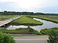
The Poquoson Museum opened in 2003. It is on a 16-acre property. The museum has an old farmhouse from around 1900. It also has farm buildings and a country store. In 2013, the museum added a marsh walk. This walk has platforms and signs about local wildlife and plants.
Education in Poquoson
Poquoson City Public Schools serve the city. There are four public schools:
- Poquoson Primary School (Kindergarten, 1st, and 2nd grades)
- Poquoson Elementary School (3rd, 4th, and 5th grades)
- Poquoson Middle School (6th, 7th, and 8th grades)
- Poquoson High School (9th–12th grades)
The mascot for Poquoson schools is the Bull Islander. It is often shortened to "bull" or "islander."
There are no private schools or colleges in Poquoson itself. However, there are several nearby. These include Hampton Roads Academy and Peninsula Catholic High School in Newport News. For higher education, options include Christopher Newport University in Newport News and the College of William and Mary in Williamsburg.
Sister Cities and Schools
Poquoson has one sister city:
 Le Bar-sur-Loup, Alpes-Maritimes, France.
Poquoson also has two partner schools:
 Balboa Academy, Panama
 Uruguayan American School, Uruguay
Notable People from Poquoson
- Baiju Bhatt, co-founder of Robinhood
- Kyle Crockett, baseball player for the Cleveland Indians
- Kitty O'Brien Joyner, NASA's first female engineer
- Chad Pinder, baseball player for the Oakland Athletics
Gallery
-
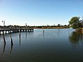
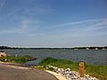
View from the old Whitehouse Cove public boat ramp
-
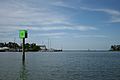
Poquoson Marina near Owen's Marina and Whitehouse Cove leading out towards the Chesapeake Bay
-
Wythe Creek Road approaching the city from Hampton across Brick Kiln Creek
-
Boats docked during the winter at Messick Point
-
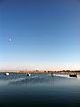
Looking towards the city from Messick Point
-
View of the Poquoson River facing towards York County from the end of Hunts Neck Road


See also
 In Spanish: Poquoson para niños
