Bowling Green, Virginia facts for kids
Quick facts for kids
Bowling Green, Virginia
|
|||
|---|---|---|---|
|
Town
|
|||

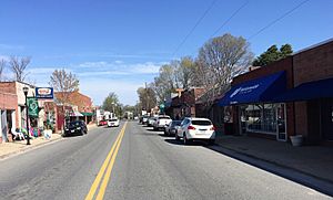
Main Street, Bowling Green
|
|||
|
|||

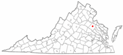
Location in Virginia
|
|||
| Country | United States | ||
| State | |||
| County | Caroline | ||
| Founded | 1837 | ||
| Area | |||
| • Total | 1.63 sq mi (4.22 km2) | ||
| • Land | 1.60 sq mi (4.15 km2) | ||
| • Water | 0.02 sq mi (0.06 km2) | ||
| Elevation | 226 ft (69 m) | ||
| Population
(2010)
|
|||
| • Total | 1,111 | ||
| • Estimate
(2019)
|
1,175 | ||
| • Density | 732.54/sq mi (282.81/km2) | ||
| Time zone | UTC−5 (Eastern (EST)) | ||
| • Summer (DST) | UTC−4 (EDT) | ||
| ZIP codes |
22427-22428
|
||
| Area code(s) | 804 | ||
| FIPS code | 51-08888 | ||
| GNIS feature ID | 1498454 | ||
| Website | Official website: http://www.townofbowlinggreen.com/ | ||
Bowling Green is a small town in Caroline County, Virginia, United States. In 2010, about 1,111 people lived there.
Bowling Green has been the main town, or county seat, of Caroline County since 1803. It is famous for being a very old place for horse racing in America. It is also home to one of the oldest Masonic Lodges in Virginia. Plus, it has the oldest house in Virginia that people have lived in continuously.
Contents
History of Bowling Green
The town of Bowling Green was once called New Hope. A very old road used to run through this area. It connected Richmond to the Potomac River, where people could take a ferry to Charles County, Maryland.
One of the first stagecoach lines in the United States used this road regularly. In the 1700s, a place called New Hope Tavern was built along the road. The area around it then became known as New Hope.
How the Town Got Its Name
The town was later renamed after a large plantation called "The Bowling Green". The owner of this plantation, Dache Carmine, founded the town. He gave land and money for a new courthouse when the town became the county seat in 1803.
The name "Bowling Green" might come from a large, flat grassy area in front of the plantation house. This area was about 2 acres (8,100 m²) in size. The Bowling Green Estate was also one of the first places in America to have a track for horse racing.
The main house of the plantation was built around 1741. It is a very old and important building in Virginia. It is listed on both the Virginia Landmarks Register and the National Register of Historic Places. This means it's a special historical site.
Town Growth and Key Events
The current Caroline County Court House was built in 1835. Bowling Green officially became a town about two years later, in 1837.
The Richmond, Fredericksburg and Potomac Railroad was built nearby in the 1830s. This railway was very important. It connected major northern railroads in Washington, D.C., with southern railroads in Richmond. Today, it is still a big railway for cargo and Amtrak passenger trains.
In 1855, a book describing towns said Bowling Green had two churches, three stores, two mills, and about 300 people.
Modern Roads and Military Base
Today, Bowling Green is located along Virginia State Route 2. This was one of the first main roads between Richmond and Fredericksburg. Later, U.S. Route 301 was built through the area. This road connects Richmond to Baltimore, Maryland.
A newer road, Virginia State Route 207, goes from Bowling Green west to Carmel Church. There, it meets Interstate 95 and U.S. Route 1, which are major north-south highways. The musician Jason Manns grew up in Bowling Green.
In 1941, the U.S. government bought a large area of land near Bowling Green. This land became a military training base. It was first named after a general, A.P. Hill. In 2023, its name was changed to Fort Walker. It was renamed to honor Mary Edwards Walker, a brave surgeon and the only woman to receive the Medal of Honor. Thousands of soldiers train at Fort Walker every year. It has also hosted large gatherings for the Boy Scouts of America.
Historic Places in Bowling Green
Besides "The Bowling Green" plantation, several other places in town are listed on the National Register of Historic Places. These include Auburn, the Bowling Green Historic District, the Caroline County Courthouse, and Green Falls.
Geography
Bowling Green is located at 38°3′12″N 77°20′51″W / 38.05333°N 77.34750°W.
The town covers about 1.6 square miles (4.2 square kilometers) in total. Most of this area is land, with a small part being water.
Population Information
| Historical population | |||
|---|---|---|---|
| Census | Pop. | %± | |
| 1850 | 377 | — | |
| 1860 | 237 | −37.1% | |
| 1870 | 395 | 66.7% | |
| 1880 | 426 | 7.8% | |
| 1890 | 511 | 20.0% | |
| 1900 | 458 | −10.4% | |
| 1910 | 433 | −5.5% | |
| 1920 | 463 | 6.9% | |
| 1930 | 422 | −8.9% | |
| 1940 | 541 | 28.2% | |
| 1950 | 616 | 13.9% | |
| 1960 | 528 | −14.3% | |
| 1970 | 528 | 0.0% | |
| 1980 | 665 | 25.9% | |
| 1990 | 727 | 9.3% | |
| 2000 | 936 | 28.7% | |
| 2010 | 1,111 | 18.7% | |
| 2019 (est.) | 1,175 | 5.8% | |
| U.S. Decennial Census | |||
In the year 2000, there were 936 people living in Bowling Green. There were 387 households and 212 families. The town had about 587 people per square mile (227 per square kilometer).
Most of the people in town were White (80.13%). About 18.38% were African American. A small number of people were Native American or from other backgrounds. About 1.92% of the population was Hispanic or Latino.
About 22.5% of households had children under 18. Many households (40.6%) were married couples. About 45% of households were not families. Almost 40% of households had only one person living there. About 20.9% of people living alone were 65 or older.
The average household had 2.10 people, and the average family had 2.81 people. The population was spread out in age. About 17.1% were under 18. About 32.7% were 65 or older. The average age in town was 48 years.
See also
 In Spanish: Bowling Green (Virginia) para niños
 | Audre Lorde |
 | John Berry Meachum |
 | Ferdinand Lee Barnett |


