
Werowocomoco facts for kids
|
Werowocomoco Archaeological Site
|
|

Powhatan in a longhouse at Werowocomoco (detail of John Smith map, 1612)
|
|

Location in Virginia

Location in the United States
|
|
| Location | 3051 Ginny Hill Rd., Gloucester, Virginia |
|---|---|
| Area | 45 acres (18 ha) |
| Built | 1607 |
| NRHP reference No. | 06000138 |
Quick facts for kids Significant dates |
|
| Added to NRHP | March 15, 2006 |
Werowocomoco was a very important village for the Powhatan people. It was the main home and center of power for their great leader, Chief Powhatan. This was especially true when English settlers arrived and built Jamestown in 1607.
The name Werowocomoco comes from the Powhatan language. It means "leader's settlement" or "place of the chief." English settlers wrote about this town in 1608. They said it was on the north side of the York River in what is now Gloucester County. The river and a narrow piece of land separated it from Jamestown.
For a long time, people thought a place called Powhatan's Chimney was the site of Werowocomoco. This site had old ruins linked to a house said to be built for Powhatan. But in 2003, archaeologists found what they believe is the real site. It's further west on the York River, at a place called Purtan Bay. They found many old items there. These items showed people lived there from the 1200s to the 1600s. The first settlement started around 1270 CE. Large earthworks were built around 1400 CE.
Some people think the area the Native Americans called Werowocomoco might have included both the Purtan Bay site and Powhatan's Chimney. In the Algonquian language, the name for the chief's village wasn't just one spot. It meant the general lands where he lived. These groups often moved their homes within a larger area.
Contents
History of Werowocomoco
Life Before Europeans Arrived
Scientists used a method called radiocarbon dating on items found at the site. This showed that people first settled Werowocomoco around 1270 CE. This was long before Europeans came to America. As the village grew, people cleared forests. This is shown by a decrease in certain types of wood and nuts found. Corn (maize) became a major food source later, closer to the time Europeans arrived.
Chief Powhatan's Rule
Werowocomoco became well-known to the first English settlers. It was the home of Wahunsenacawh, also known as Chief Powhatan. He was the main leader, or weroance, of the area. The English called him Powhatan after his original small village. That village was near the James River falls, where Richmond, Virginia is today.
Chief Wahunsenacawh told John Smith that he started gaining power west of Werowocomoco. We don't know exactly when he moved to Werowocomoco. But it was already a known important place for his people. He might have wanted to use it because it was linked to earlier Native American leaders. While living there, he received gifts from many Virginia Algonquian tribes. In return, he gave them food during hard times. He also offered military protection and spiritual help. He shared special items like copper and certain shell beads. Werowocomoco was where Powhatan and the English colonists met many times.
First Meetings with Jamestown Settlers
Werowocomoco is famous as the place where John Smith met Chief Powhatan. Smith had been captured by Powhatan's brother, Opechancanough, in December 1607. According to Smith's story from 1624, Pocahontas, Powhatan's daughter, saved him from being killed. However, many historians doubt this story. Smith didn't mention it in his earlier writings (1608 and 1612). He only wrote about it 17 years later. By then, Pocahontas was famous in England and had died. This meant she couldn't disagree with his story. During this time, severe droughts likely caused less corn to be grown at Werowocomoco.
Why the Village Was Left Empty
In the early years, the English colony faced a very hard winter. This time was known as the Starving Time. In December 1608, Powhatan offered to sell the English a ship full of corn. He wanted a grindstone, swords, guns, chickens, copper, and beads in return. He also wanted some men to build him an English-style house. Smith pretended to agree. But he secretly planned to take the corn by force instead of giving Powhatan weapons.
Smith sent four German men ahead to work on the house. He then sailed to Werowocomoco on December 29 with a small group. Powhatan might have also been planning something. On the way, Smith heard that Powhatan was planning to ambush his group.
Smith arrived at Werowocomoco on January 12, 1609. The next day, he saw the progress on Powhatan's new house. Both Smith's men and Powhatan's men tried to trick each other during talks. After these attempts, the English got their corn. Smith's group then went to trade with Powhatan's brother, Opechancanough. They used guns to get food supplies from him. A few days later, they returned to Werowocomoco. They were surprised to find the house unfinished and the whole town empty. They blamed the Germans. But it's more likely that Powhatan decided to move. He wanted to be in a place harder for the troublesome colonists to reach.
Powhatan first moved his main home to Orapakes. This was in a swamp near the Chickahominy River. Later, between 1611 and 1614, he moved further north to Matchut. This new home was in King William County, on the north side of the Pamunkey River. After Powhatan died in 1618, Opechancanough became the main chief. He ruled fewer tribes than Powhatan had. He used a nearby place called Youghtanund as his capital. Like Werowocomoco, this was where he received gifts from the tribes he ruled.
Finding Werowocomoco Again
The exact location of Werowocomoco was forgotten by the English in the 1600s. Scholars thought West Point might be the place. This town is where the Pamunkey and Mattaponi rivers meet. This seemed to fit John Smith's description of the Powhatan village:
Fourteene myles from the river Powhatan is the river Pamunkee, which is navaginable 60 or 70 myles, but with Cathes and small Barkes 30 or 40 myles further. At the ordinary flowing of the salt water, it divideth itself into two gallent branches. On the South side inhabited the people Toughtamand[?], who haue about 60 men for warres. On the North branch Mattapoment [Mattaponi], who has 30 men. Where the river is divided the Country is called Pamaunkee [Pamunkey], and nourisheth neare 300 able men. About 25 myles lower on the North side of this river is Werawocomoco, where their great king inhabited when I was delivered him prisoner; yet there are not past 40 able men. [sic]
Powhatan's Chimney Site
Later, local people believed Werowocomoco was near Powhatan's Chimney. This spot is about 25 miles (40 km) east of West Point, Virginia. It's in the area of Timberneck Bay, a bit upriver from Gloucester Point. The chimney there was linked to the unfinished house John Smith saw being built for Powhatan. Local stories changed this to a house built by Smith for Powhatan. Because of this, English settlers called the area Werowocomoco. The US Post Office later shortened the name to Wicomico for easier use.
The Real Discovery
In 1977, Daniel Mouer, an archaeologist, found a possible location for Werowocomoco. It was further west along the York River at Purtan Bay. This site is less than 25 miles (40 km) from West Point and 15 miles (24 km) from Jamestown. It's about 7 miles (11 km) west of Gloucester. He collected pieces of Native American pottery and other items. These items dated from the Late Woodland Period up to the time Europeans arrived. This showed that the area was a "possible site of 'Werowocomoco'." Because of his findings, the area was named a Virginia Historic Site.
In 2002, the landowners, the Ripleys, allowed more archaeological work. They had already found many old spear points on their land. From March 2002 to April 2003, archaeologists carefully explored part of the property. They dug many small test holes. They found thousands of items throughout the site. This showed the site was mostly untouched. They even found a blue bead that might have been made in Europe for trading.
These findings showed a large settlement covering 50 acres (200,000 m2). It was used for a long time and matched old descriptions. This suggested the farm was the former site of Werowocomoco. Randolph Turner, a director for Virginia's historic resources, said in 2003, "We believe we have enough proof to confirm that the property is indeed the village of Werowocomoco." Old maps also support these ideas.
Since 2003, a team of archaeologists has been working at this site. They and the landowners have worked with the Virginia Council on Indians. This helps plan and carry out the digs. Native American tribes from Virginia, some of whom are descendants of Powhatan's people, continue to give advice. Digs since 2003 have found signs of a large town. This includes two 200-foot (61 m)-long, curved, earthwork ditches. They were built 1,000 feet (300 m) from the river around 1400. This was 200 years before the English first visited. In 2006, the Werowocomoco Archeological Site was added to the National Register of Historic Places (NRHP). In the future, experts hope to learn more about how Powhatan's government worked.
In 2014, President Barack Obama suggested using federal money to buy this site. The goal was to make it part of the National Park System. This would allow Werowocomoco to be open to the public. The National Park Service bought the property in the summer of 2016.
Werowocomoco Archaeological Site Today

Thane Harpole and David Brown, two archaeologists from Gloucester, have been key to the work at the Purtan Bay site since 2002. That year, the Werowocomoco Research Group was formed to start digging. This group is a team effort. It includes the College of William and Mary and the Virginia Department of Historic Resources. Local Virginia tribes also advise them.
The digs have shown a spread-out community of about 50 acres (200,000 m2). People lived there from the 1200s to the early 1600s. Items found include Native pottery and stone tools. There are also plant and animal remains from a large living area. The Research Group has also found many English trade goods. These are made from glass, copper, and other metals. They came from Jamestown. This matches what colonists wrote about trading at Werowocomoco. They noted that Powhatan was very interested in English items, especially copper, when Jamestown was new.
In 2004, researchers found two large earthworks. These are curved ditches, each over 200 feet (61 m) long. They are about 1,000 feet (300 m) from the river. They might be part of a D-shaped structure shown on John Smith's 1612 map. Researchers found that the ditches date back to about 1400 CE. This means Virginia Indians had a long-term settlement here over 200 years before the English arrived. Earthwork structures were often important for special centers. These ditches might have marked off a sacred area. New discoveries from the digs are helping experts understand how Virginia Indians and Europeans interacted. The time they spent together at this site was short compared to the many hundreds of years Native Americans lived there before.
This project is special because archaeologists have worked closely with members of local Virginia Indian tribes. These include the Mattaponi, Pamunkey, and Upper Mattaponi tribes. Some of their people see these sites as sacred. This is because they contain burial items of their ancestors.
When I step on this site folks...I just feel different. The spirituality just touches me and I feel it.
Because of how important the discoveries are, the Werowocomoco Archaeological Site was added to the National Register of Historic Places (NRHP) in 2006.
Images for kids
-
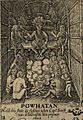
Powhatan in a longhouse at Werowocomoco (detail of John Smith map, 1612)
-
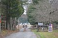
Entrance to the Werowocomoco site
