Stokes County, North Carolina facts for kids
Quick facts for kids
Stokes County
|
|||
|---|---|---|---|
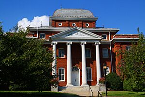
Stokes County Courthouse in Danbury
|
|||
|
|||
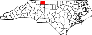
Location within the U.S. state of North Carolina
|
|||
 North Carolina's location within the U.S. |
|||
| Country | |||
| State | |||
| Founded | 1789 | ||
| Named for | John Stokes | ||
| Seat | Danbury | ||
| Largest community | King | ||
| Area | |||
| • Total | 456.14 sq mi (1,181.4 km2) | ||
| • Land | 449.35 sq mi (1,163.8 km2) | ||
| • Water | 6.79 sq mi (17.6 km2) 1.49% | ||
| Population
(2020)
|
|||
| • Total | 44,520 | ||
| • Estimate
(2023)
|
45,532 | ||
| • Density | 99.08/sq mi (38.26/km2) | ||
| Time zone | UTC−5 (Eastern) | ||
| • Summer (DST) | UTC−4 (EDT) | ||
| Congressional district | 5th | ||
Stokes County is a county in North Carolina, a state in the United States. In 2020, about 44,520 people lived there. The main town and county seat is Danbury.
Stokes County is part of the larger Winston-Salem area. This area is also part of the Piedmont Triad, which includes Greensboro and High Point.
Contents
History of Stokes County
Stokes County was created in 1789 from Surry County. Before 1770, it was part of Rowan County. The county is named after John Stokes. He was a brave captain in the American Revolutionary War. He was badly hurt in a battle in 1780. After the war, he became a judge.
In 1849, the southern part of Stokes County became Forsyth County.
Early Settlers and the Great Wagon Road
Most people settled in Stokes County between 1750 and 1775. The Great Wagon Road was a major travel route. It went through the eastern part of the county. This road helped many settlers come from Virginia and other colonies like Pennsylvania.
Stokes County During the Civil War
When North Carolina decided to leave the United States in 1861, John Hill represented Stokes County. Sadly, he died during the meeting in Raleigh. He is buried near Germanton.
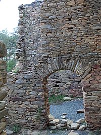
During the American Civil War, the Moratock Iron Furnace near Danbury made metal for the Confederate Army. Union soldiers destroyed it in April 1865. This happened when General George Stoneman's cavalry rode through the area.
Hanging Rock State Park's Beginning
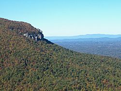
Hanging Rock State Park was created mostly from land given in 1936. By 2005, it covered about 6,921 acres (28 square kilometers). Many buildings and paths in the park were built by the Civilian Conservation Corps. This group worked there between 1935 and 1942. The park is on top of the Sauratown Mountains. It has a visitor center, a lake, and many trails for hiking and climbing. There are also picnic areas and places to camp.
Geography and Nature
Stokes County covers about 456 square miles (1,181 square kilometers). Most of this area is land, with a small part being water.
The county is in the Piedmont region of western North Carolina. This means the land is mostly gently rolling hills. Stokes County is also part of Appalachia. The Sauratown Mountains run through the middle of the county. These mountains are named after the Saura Native American tribe. They lived in the county before European settlers arrived.
The Sauratown Mountains are a chain of jagged ridges. They are a small part of the Blue Ridge Mountains that are much further west. Even though they only cover a small part of Stokes County, they are very noticeable. They rise sharply from 800 to 1,700 feet (244 to 518 meters) above the land around them. Moore's Knob is the highest point, reaching 2,579 feet (786 meters). Most of the county is less than 1,000 feet (305 meters) above sea level.
The Dan River flows through Stokes County for over 56 miles (90 kilometers). This river is great for recreation. Stokes County is home to Hanging Rock State Park. It also has most of Belews Lake in its southeastern corner.
Climate and Weather Patterns
| Weather chart for Danbury, NC | |||||||||||||||||||||||||||||||||||||||||||||||
|---|---|---|---|---|---|---|---|---|---|---|---|---|---|---|---|---|---|---|---|---|---|---|---|---|---|---|---|---|---|---|---|---|---|---|---|---|---|---|---|---|---|---|---|---|---|---|---|
| J | F | M | A | M | J | J | A | S | O | N | D | ||||||||||||||||||||||||||||||||||||
|
3.7
48
24
|
3
52
26
|
4.3
60
32
|
3.6
70
40
|
4
77
49
|
4
84
59
|
5
88
64
|
4.3
86
62
|
4.6
80
54
|
3.6
71
42
|
3.3
62
33
|
3.6
51
26
|
||||||||||||||||||||||||||||||||||||
| temperatures in °F precipitation totals in inches source: Applied Climate Information System |
|||||||||||||||||||||||||||||||||||||||||||||||
|
Metric conversion
|
|||||||||||||||||||||||||||||||||||||||||||||||
Stokes County has a mixed-humid climate. This means it gets both warm and cold weather, with plenty of rain. In Danbury, the county seat, about 39.73 inches (100.9 centimeters) of rain falls each year. About 9.0 inches (22.9 centimeters) of snow also falls.
Temperatures usually range from a low of 24.2°F (–4.3°C) in January to a high of 87.7°F (30.9°C) in July. The hottest temperature ever recorded was 103.0°F (39.4°C) in August 1983. The coldest was –10°F (–23.3°C) in January 1985. In 1996, a big snowstorm brought 34.0 inches (86.4 centimeters) of snow over three days.
Protected Natural Areas
- East Walnut Cove Community Park
- Hanging Rock State Park
- Hill Farm Game Land
Major Rivers and Lakes
- Belews Creek
- Belews Lake
- Big Beaver Island Creek
- Big Creek
- Buffalo Creek
- Crooked Creek
- Dan River
- Flat Shoal Creek
- Little Dan River
- Little Neatman Creek
- Little Peters Creek
- Little Yadkin River
- Mill Creek
- Neatman Creek
- Oldfield Creek
- Peters Creek
- Pinch Gut Creek
- Snow Creek
- Vade Mecum Creek
Neighboring Counties
- Patrick County, Virginia – to the north
- Henry County, Virginia – to the northeast
- Rockingham County – to the east
- Guilford County – to the southeast
- Forsyth County – to the south
- Surry County – to the west
Main Roads and Highways

 Future I-74
 US 52
US 52 US 311
 NC 8
NC 8 NC 65
NC 65 NC 66
NC 66 NC 89
NC 89 NC 268
 NC 704
 NC 770
 NC 772
People of Stokes County
| Historical population | |||
|---|---|---|---|
| Census | Pop. | %± | |
| 1790 | 8,423 | — | |
| 1800 | 11,026 | 30.9% | |
| 1810 | 11,645 | 5.6% | |
| 1820 | 14,033 | 20.5% | |
| 1830 | 16,196 | 15.4% | |
| 1840 | 16,265 | 0.4% | |
| 1850 | 9,206 | −43.4% | |
| 1860 | 10,402 | 13.0% | |
| 1870 | 11,208 | 7.7% | |
| 1880 | 15,353 | 37.0% | |
| 1890 | 17,199 | 12.0% | |
| 1900 | 19,866 | 15.5% | |
| 1910 | 20,151 | 1.4% | |
| 1920 | 20,575 | 2.1% | |
| 1930 | 22,290 | 8.3% | |
| 1940 | 22,656 | 1.6% | |
| 1950 | 21,520 | −5.0% | |
| 1960 | 22,314 | 3.7% | |
| 1970 | 23,782 | 6.6% | |
| 1980 | 33,086 | 39.1% | |
| 1990 | 37,223 | 12.5% | |
| 2000 | 44,712 | 20.1% | |
| 2010 | 47,401 | 6.0% | |
| 2020 | 44,520 | −6.1% | |
| 2023 (est.) | 45,532 | −3.9% | |
| U.S. Decennial Census 1790–1960 1900–1990 1990–2000 2010 2020 |
|||
In 2020, the census counted 44,520 people living in Stokes County. There were 19,578 households and 13,348 families. Most people living in the county are White.
Economy and Jobs
Stokes County is often called a "bedroom community." This means many people who live here travel to bigger towns for work. These towns include Winston-Salem, Greensboro, and Mount Airy.
The county has faced challenges in growing its economy. However, many small and medium-sized businesses have found success. There are also retail stores, restaurants, and service businesses. The biggest employer in Stokes County is the local government and school system. In 2023, the county was rated as a "Tier 2" county. This means its economy is somewhere between the most successful and the most struggling counties in the state.
Education in Stokes County
Stokes County Schools serves the county's students. It has 11 elementary schools, 3 middle schools, and 5 high schools. There is also an early college program.
Communities in Stokes County
Cities in Stokes County
- Danbury (This is the county seat, where the main government offices are.)
- King (This is the largest community. Part of it is also in Forsyth County.)
Towns in Stokes County
- Walnut Cove
- Stokesdale (Most of this town is in Guilford County.)
Villages in Stokes County
- Tobaccoville (Part of this village is also in Forsyth County.)
Census-Designated Places
These are areas that are like towns but are not officially incorporated.
Other Communities (Unincorporated)
- Aarons Corner
- Asbury
- Boyles Chapel
- Brook Cove
- Brown Mountain
- Campbell
- Capella
- Ceramic
- Chestnut Grove
- Collinstown
- Dalton
- Delta
- Dillard
- Dodgetown
- Flat Rock
- Flat Shoals
- Francisco
- Gap
- Hartman
- Lawsonville
- Meadows
- Moores Springs
- Mountain View
- Mount Olive
- Neatman
- Oak Ridge
- Pine Hall
- Poplar Springs
- Prestonville
- Quaker Gap
- Rosebud
- Sandy Ridge
- Volunteer
- Westfield
Townships
Townships are smaller areas within a county, often used for local government or land division.
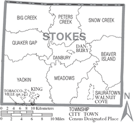
- Beaver Island
- Big Creek
- Danbury
- Meadows
- Peters Creek
- Quaker Gap
- Sauratown
- Snow Creek
- Yadkin
Images for kids
See also
 In Spanish: Condado de Stokes para niños
 | Audre Lorde |
 | John Berry Meachum |
 | Ferdinand Lee Barnett |


