Wytheville, Virginia facts for kids
Quick facts for kids
Wytheville, Virginia
|
|||
|---|---|---|---|
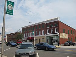
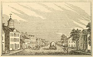
Main Street in Wytheville
|
|||
|
|||
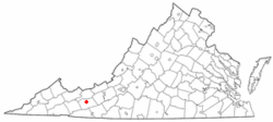
Location in the Commonwealth of Virginia
|
|||
| Country | United States | ||
| State | Virginia | ||
| County | Wythe | ||
| Area | |||
| • Town | 14.58 sq mi (37.77 km2) | ||
| • Land | 14.49 sq mi (37.53 km2) | ||
| • Water | 0.09 sq mi (0.24 km2) | ||
| Elevation | 2,287 ft (697 m) | ||
| Population
(2020)
|
|||
| • Town | 8,265 | ||
| • Estimate
(2022)
|
8,177 | ||
| • Density | 570.4/sq mi (211.07/km2) | ||
| • Metro | 28,290 | ||
| U.S. Census Bureau, 2020 Census | |||
| Time zone | UTC−5 (EST) | ||
| • Summer (DST) | UTC−4 (EDT) | ||
| ZIP code |
24382
|
||
| Area code(s) | 276 | ||
| FIPS code | 51-88000 | ||
| GNIS feature ID | 1498537 | ||
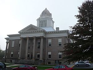
Wytheville (pronounced WITH-vil) is a town in Wythe County, Virginia, United States. It's the main town and county seat. The town is named after George Wythe, who was an important person in American history. He signed the United States Declaration of Independence and was a teacher to Thomas Jefferson.
In 2020, about 8,264 people lived in Wytheville. It's an important spot because two major highways, I-77 and I-81, meet there. During the American Civil War, Wytheville was attacked twice because of its important location. Edith Bolling Wilson, who became the second wife of President Woodrow Wilson, was born in Wytheville.
Contents
History of Wytheville
Wythe County was created in 1789. It was named after George Wythe, a very important legal figure and a signer of the United States Declaration of Independence. In 1790, some people donated land to start a town and a county seat. The area was divided into lots, and it was first known as Wythe Court House.
In 1792, the town was officially named Evansham, after a local person named Jesse Evans. But after a big fire in 1839, the town was renamed Wytheville. At that time, about 500 people lived there.
The Polio Epidemic of 1950
In the summer of 1950, Wytheville faced a serious health challenge. A disease called polio spread quickly. Polio could cause paralysis in children and adults. Out of about 5,513 people in the town, 184 got sick, and 17 people died. To try and stop the spread, parents kept their children indoors, and large gatherings were canceled from June to August.
When people got sick, ambulances took them about 80 miles to a hospital in Roanoke, Virginia. If ambulances weren't available, even hearses from local funeral homes were used. Sadly, African-American patients were often not allowed into the Roanoke hospital. They had to travel much farther, about 180 miles, to a hospital in Richmond. This showed the unfairness of the time.
The town council put up signs at the entrances to the county, warning visitors about the epidemic. They asked tourists to come back another year. By the end of the summer, all these signs were gone, either stolen or destroyed. Even though a reward was offered, no one came forward with information.
Historic Places to See
Several important places in Wytheville are listed on the National Register of Historic Places. These include the Crockett's Cove Presbyterian Church, the Haller-Gibboney Rock House, Loretto, St. John's Episcopal Church, St. John's Lutheran Church and Cemetery, the Wythe County Poorhouse Farm, and the Wytheville Historic District. These places help us learn about the town's past.
Wytheville's Geography
Wytheville is located at coordinates 36.947679 degrees North and -81.086955 degrees West. The town covers about 14.58 square miles (37.77 square kilometers). Only a very small part of this area is water.
Wytheville is a very important spot for travel. It's where I-77 and I-81, two major interstate highways, cross paths. This makes it a busy place for travelers. It's about halfway between Bristol, Tennessee/Virginia, and Roanoke. If you're traveling on I-77, Wytheville is also about halfway between Charleston, West Virginia, and Charlotte, North Carolina.
Because so many major roads meet here, and it's located in the foothills of the Blue Ridge Mountains, Wytheville is known as "The Hub of Southwest Virginia" and "The Crossroads of the Blue Ridge." This means it's a central point for the region. In the future, another interstate, Interstate 74, is planned to go through Wytheville.
Wytheville's Climate
Because Wytheville is located at a higher elevation, its climate is often described as mountain temperate or humid subtropical. This means it has warm and humid summers, but they are usually cooler than places at lower elevations in Virginia. On average, there are only about 4 or 5 days a year where the temperature reaches 90°F (32°C) or higher. Winters are generally cool to cold. Sometimes it can get very cold, with temperatures dropping below 10°F (-12°C) about 11 nights a year.
The average temperature in January is about 32.9°F (0.5°C), and in July, it's about 71.7°F (22.1°C). Wytheville gets about 20.5 inches (52 cm) of snow each winter, mostly from December to March.
| Climate data for Wytheville, Virginia, elev. 2,458 feet (749 m) (1991–2020 normals, extremes 1893–present) | |||||||||||||
|---|---|---|---|---|---|---|---|---|---|---|---|---|---|
| Month | Jan | Feb | Mar | Apr | May | Jun | Jul | Aug | Sep | Oct | Nov | Dec | Year |
| Record high °F (°C) | 78 (26) |
78 (26) |
83 (28) |
88 (31) |
91 (33) |
98 (37) |
98 (37) |
98 (37) |
97 (36) |
90 (32) |
80 (27) |
76 (24) |
98 (37) |
| Mean daily maximum °F (°C) | 42.2 (5.7) |
45.9 (7.7) |
54.0 (12.2) |
64.5 (18.1) |
72.5 (22.5) |
79.3 (26.3) |
82.8 (28.2) |
81.8 (27.7) |
76.5 (24.7) |
66.6 (19.2) |
55.5 (13.1) |
45.8 (7.7) |
63.9 (17.7) |
| Daily mean °F (°C) | 32.9 (0.5) |
35.7 (2.1) |
42.6 (5.9) |
51.9 (11.1) |
60.5 (15.8) |
68.0 (20.0) |
71.7 (22.1) |
70.6 (21.4) |
64.6 (18.1) |
53.7 (12.1) |
43.2 (6.2) |
36.2 (2.3) |
52.6 (11.4) |
| Mean daily minimum °F (°C) | 23.5 (−4.7) |
25.6 (−3.6) |
31.2 (−0.4) |
39.2 (4.0) |
48.5 (9.2) |
56.7 (13.7) |
60.6 (15.9) |
59.5 (15.3) |
52.8 (11.6) |
40.7 (4.8) |
31.0 (−0.6) |
26.6 (−3.0) |
41.3 (5.2) |
| Record low °F (°C) | −20 (−29) |
−9 (−23) |
0 (−18) |
12 (−11) |
23 (−5) |
30 (−1) |
39 (4) |
35 (2) |
25 (−4) |
12 (−11) |
2 (−17) |
−13 (−25) |
−20 (−29) |
| Average precipitation inches (mm) | 3.16 (80) |
2.88 (73) |
3.60 (91) |
3.75 (95) |
4.30 (109) |
4.06 (103) |
4.22 (107) |
3.63 (92) |
3.36 (85) |
2.92 (74) |
2.62 (67) |
3.18 (81) |
41.68 (1,059) |
| Average snowfall inches (cm) | 5.9 (15) |
4.9 (12) |
2.9 (7.4) |
0.5 (1.3) |
0.0 (0.0) |
0.0 (0.0) |
0.0 (0.0) |
0.0 (0.0) |
0.0 (0.0) |
0.0 (0.0) |
0.4 (1.0) |
3.8 (9.7) |
18.4 (47) |
| Average precipitation days (≥ 0.01 in) | 11.1 | 10.8 | 11.9 | 12.0 | 13.5 | 12.8 | 12.4 | 11.1 | 9.9 | 9.0 | 9.2 | 11.3 | 135.0 |
| Average snowy days (≥ 0.1 in) | 2.8 | 2.5 | 1.5 | 0.3 | 0.0 | 0.0 | 0.0 | 0.0 | 0.0 | 0.0 | 0.4 | 2.1 | 9.6 |
| Source: NOAA | |||||||||||||
Wytheville's Population
| Historical population | |||
|---|---|---|---|
| Census | Pop. | %± | |
| 1860 | 1,111 | — | |
| 1870 | 1,671 | 50.4% | |
| 1880 | 1,885 | 12.8% | |
| 1890 | 2,570 | 36.3% | |
| 1900 | 3,003 | 16.8% | |
| 1910 | 3,054 | 1.7% | |
| 1920 | 2,947 | −3.5% | |
| 1930 | 3,327 | 12.9% | |
| 1940 | 4,653 | 39.9% | |
| 1950 | 5,513 | 18.5% | |
| 1960 | 5,634 | 2.2% | |
| 1970 | 6,069 | 7.7% | |
| 1980 | 7,135 | 17.6% | |
| 1990 | 8,038 | 12.7% | |
| 2000 | 7,804 | −2.9% | |
| 2010 | 8,211 | 5.2% | |
| 2020 | 8,265 | 0.7% | |
| 2022 (est.) | 8,177 | −0.4% | |
| U.S. Decennial Census | |||
In 2020, there were 8,264 people living in Wytheville. Most of the people were White (86.3%), with 6.7% being Black or African American. Other groups included Native American, Asian, and people from two or more races. About 2.3% of the population was Hispanic or Latino.
There were about 3,922 households in the town. About 22.7% of these households had children under 18. Many households (40.8%) had just one person living alone. The average household had about 2.1 people.
About 19.5% of the people in Wytheville were under 18 years old, and 25.3% were 65 years or older. The average age in the town was 45.2 years.
Local Media
Wytheville has a radio station called WYVE, which started broadcasting in 1949. It's on the AM dial at 1280 and also on FM at 99.9. This station, along with WXBX and WLOY, is owned by Three Rivers Media Corp. Their studios are near Downtown Wytheville.
Fun Places to Visit
- Hitachi Energy Arena: This is a large arena with 3,600 seats. It's home to the Blue Ridge Bobcats, a hockey team.
- The Edith Bolling Wilson Birthplace: You can visit the house where Edith Bolling Wilson, the second wife of President Woodrow Wilson, was born.
- Big Walker Lookout Tower: This is a 100-foot tall observation tower located about 12 miles north of Wytheville. From the top, you can see amazing views!
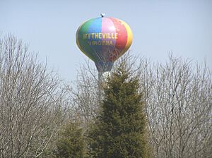
- The Chautauqua Festival: Every year since 1985, Wytheville hosts this fun festival during the third weekend in June. It has live concerts, magic shows, arts and crafts, and even hot air ballooning! There are also dance performances, activities for kids, and lots of different carnival-style foods. The hot air balloons at the festival inspired the painting of the town's water tower, which looks like a hot air balloon. You can see it from I-81 near the I-77 interchange. The festival takes place at Elizabeth Brown Memorial Park.
Famous People from Wytheville
Many notable people have connections to Wytheville:
- David French Boyd: He was born in Wytheville in 1834 and later became the president of Louisiana State University.
- William Gibson: A famous writer who spent much of his childhood here.
- William Nauns Ricks: A poet.
- E. Lee Trinkle: He served as the Governor of Virginia.
- James Walker: A Lieutenant Governor of Virginia and a Confederate General.
- Edith Bolling Wilson: The second wife of President Woodrow Wilson, born in Wytheville.
- Robert E. Withers: A former U.S. Senator, Lieutenant Governor of Virginia, and the first American Ambassador to China.
See also
 In Spanish: Wytheville para niños
 | Stephanie Wilson |
 | Charles Bolden |
 | Ronald McNair |
 | Frederick D. Gregory |


