St. Charles, Virginia facts for kids
Quick facts for kids
St. Charles, Virginia
|
|
|---|---|

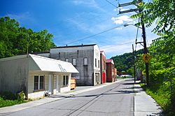
Buildings in St. Charles
|
|

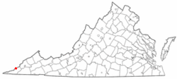
Location of St. Charles, Virginia
|
|
| Country | United States |
| State | Virginia |
| County | Lee |
| Area | |
| • Total | 0.18 sq mi (0.46 km2) |
| • Land | 0.18 sq mi (0.46 km2) |
| • Water | 0.00 sq mi (0.00 km2) |
| Elevation | 1,522 ft (464 m) |
| Population
(2020)
|
|
| • Total | 72 |
| • Density | 622.0/sq mi (240.14/km2) |
| Time zone | UTC−5 (Eastern (EST)) |
| • Summer (DST) | UTC−4 (EDT) |
| ZIP code |
24282
|
| Area code(s) | 276 |
| FIPS code | 51-69792 |
| GNIS feature ID | 1497128 |
St. Charles is a small community in Lee County, Virginia, in the United States. It is known as a census-designated place, which means it's a specific area identified by the government for statistics. St. Charles used to be an official town. In 2020, about 72 people lived there.
Contents
History of St. Charles
The community of St. Charles got its start a long time ago. In 1908, a post office was opened there, which helped people send and receive mail.
Becoming a Town
St. Charles officially became a town on January 10, 1914. This meant it had its own local government. The community was named after Charles Bondurant, who was important in the coal mining business in the area.
Why St. Charles Is No Longer a Town
In 2022, the government of Virginia decided to end St. Charles's status as a town. This happened because no one had run for town leadership in the last two elections. This meant the town no longer had people to run its local government.
Where St. Charles Is Located
St. Charles is found in the northern part of Lee County, Virginia. It sits in a narrow valley along a stream called Straight Creek. This creek is part of the larger Powell River system.
The community is very close to the border between Kentucky and Virginia. It is surrounded by tall, rugged hills. These include Lone Mountain to the northeast and Little Black Mountain to the northwest.
You can reach St. Charles by taking Virginia State Route 352. This road connects it to U.S. Route 421 near Pennington Gap to the south. The total area of St. Charles is about 0.18 square miles (0.46 square kilometers), and all of it is land.
Population Facts
| Historical population | |||
|---|---|---|---|
| Census | Pop. | %± | |
| 1920 | 400 | — | |
| 1930 | 457 | 14.3% | |
| 1940 | 482 | 5.5% | |
| 1950 | 550 | 14.1% | |
| 1960 | 368 | −33.1% | |
| 1970 | 368 | 0.0% | |
| 1980 | 241 | −34.5% | |
| 1990 | 206 | −14.5% | |
| 2000 | 159 | −22.8% | |
| 2010 | 128 | −19.5% | |
| 2020 | 72 | −43.7% | |
| U.S. Decennial Census | |||
In 2000, there were 159 people living in St. Charles. Most of the people living there were White (99.37%). A small number (0.63%) were Asian.
The population has changed a lot over the years. In 1950, St. Charles had its largest population with 550 people. By 2020, the number of people living there had gone down to 72.
See also
 In Spanish: St. Charles (Virginia) para niños
 | Madam C. J. Walker |
 | Janet Emerson Bashen |
 | Annie Turnbo Malone |
 | Maggie L. Walker |

