Vinton, Virginia facts for kids
Quick facts for kids
Vinton, Virginia
|
|
|---|---|

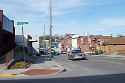
Downtown Vinton
|
|

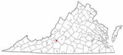
Location in Virginia
|
|
| Country | United States |
| State | Virginia |
| County | Roanoke |
| Founded | 1884 |
| Area | |
| • Total | 3.15 sq mi (8.2 km2) |
| • Land | 3.11 sq mi (8.1 km2) |
| • Water | 0.04 sq mi (0.1 km2) |
| Elevation | 925 ft (282 m) |
| Population
(2020)
|
|
| • Total | 8,059 |
| • Density | 2,558/sq mi (987.8/km2) |
| Time zone | UTC−5 (Eastern (EST)) |
| • Summer (DST) | UTC−4 (EDT) |
| ZIP Code |
24179
|
| Area code(s) | 540 and 826 |
| FIPS code | 51-81280 |
| GNIS feature ID | 1500260 |
Vinton is a friendly town located in eastern Roanoke County, Virginia, in the United States. In 2020, about 8,059 people lived there. Vinton is part of the larger Roanoke area. It is a great place to live near a bigger city.
Contents
History of Vinton
By the late 1700s, people started to settle in the Vinton area. In 1797, the Gish family built a gristmill on Glade Creek. A gristmill grinds grain into flour. Because of this mill, the area became known as Gish's Mill.
Later, a railroad called the Atlantic, Mississippi and Ohio Railroad came through the Roanoke Valley. Gish's Mill became a stop on this important train line. In the late 1870s and early 1880s, the Gish family worked to create a town around the train station.
A big meeting was held in 1883 to talk about making it an official town. In 1884, the area was officially named the Town of Vinton.
Geography and Location
Vinton is located at coordinates 37.277987 degrees North and 79.895248 degrees West.
The town covers about 3.16 square miles (8.2 square kilometers) of land.
Vinton's Neighbors and Landscape
Vinton shares a large part of its western edge with the nearby city of Roanoke. Some neighborhoods are even split between the two places. Because it is so close to Roanoke, Vinton is often called a "bedroom community." This means many people who live in Vinton travel to Roanoke for work.
The southern part of Vinton has about 1.5 miles of lakefront along the Roanoke River Gorge. This lake was made in 1904 when the Niagara dam was built. However, you can't see the lake from most parts of town. It is also hard to get to and not used much.
Vinton has different types of land, even though it is a small town. The lake is about 890 feet above sea level. The Vinton side of the lake has a steep, wooded cliff that is about 150 feet tall. The highest point in Vinton is on Olney Road, at about 1,265 feet high. From there, you can get a good view of Roanoke city.
While Vinton is completely inside Roanoke County, its ZIP Code also covers some areas in western Bedford County.
Population and People
| Historical population | |||
|---|---|---|---|
| Census | Pop. | %± | |
| 1890 | 1,057 | — | |
| 1900 | 1,438 | 36.0% | |
| 1910 | 1,928 | 34.1% | |
| 1920 | 2,779 | 44.1% | |
| 1930 | 3,610 | 29.9% | |
| 1940 | 3,455 | −4.3% | |
| 1950 | 3,629 | 5.0% | |
| 1960 | 3,432 | −5.4% | |
| 1970 | 6,347 | 84.9% | |
| 1980 | 8,027 | 26.5% | |
| 1990 | 7,665 | −4.5% | |
| 2000 | 7,782 | 1.5% | |
| 2010 | 8,098 | 4.1% | |
| 2020 | 8,059 | −0.5% | |
| U.S. Decennial Census | |||
Who Lives in Vinton?
The census in 2020 showed that 8,059 people lived in Vinton. There were 3,774 homes in the town. Most people living in Vinton are White, but people from many different backgrounds call Vinton home. About 7.2% of the people are African American or Black, and 1.2% are Asian. People from other races and those with two or more races also live here. About 3.6% of the population is Hispanic or Latino.
In 2010, there were 8,092 people living in Vinton. The town had 3,774 housing units and 3,547 households. The average income for a family in Vinton was $44,667.
Parks and Fun Things to Do
Vinton has several parks where you can play and relax.
- Vinyard Park is a large 86-acre public park just north of Vinton. It has fields for baseball, football, and soccer. There is also a playground and a picnic area. A wooden path near the entrance lets you explore a wetlands area.
- Goode Park is another public park located east of Vinton. It has fields for baseball, softball, and soccer. You can also find trails and a picnic area there.
- M. A. Banks Park is a smaller neighborhood park. It offers a basketball court, a picnic area, and a playground for kids.
Education in Vinton
Students in Vinton attend schools run by Roanoke County Public Schools.
Younger students go to Herman L. Horn Elementary School or W. E. Cundiff Elementary School. Middle school students attend William Byrd Middle School. Older students go to William Byrd High School.
For those interested in college, higher education schools are located nearby in Hollins and Roanoke.
Local News and Media
The Vinton Messenger is a weekly newspaper that shares news about the town of Vinton. The Roanoke Times, which is the main newspaper for the whole region, also covers news from Vinton.
Transportation and Roads
Getting Around Vinton
Air Travel
The closest airport with flights for travelers is the Roanoke-Blacksburg Regional Airport.
Roads for Driving
Train Service
The Norfolk Southern train lines, called the Blue Ridge District and Altavista District, run through Vinton. If you want to travel by passenger train, the closest station is in Roanoke.
Notable People from Vinton
Many interesting people have come from Vinton, including:
- Henry Brabham, a hockey executive and a former mayor of Vinton.
- David R. Goode, a leader in the railroad industry.
- David Huddleston, a well-known actor.
- Mike McGuire, who is the Head Women's Basketball Coach at Radford University.
See also
 In Spanish: Vinton (Virginia) para niños
 | Janet Taylor Pickett |
 | Synthia Saint James |
 | Howardena Pindell |
 | Faith Ringgold |

