Haysi, Virginia facts for kids
Quick facts for kids
Haysi, Virginia
|
||
|---|---|---|

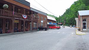
Main Street in Haysi
|
||
|
||
| Motto(s):
"Where Your Break Begins"
|
||
| Country | United States | |
| State | Virginia | |
| County | Dickenson | |
| Incorporated | February 17, 1936 | |
| Area | ||
| • Total | 3.77 sq mi (9.76 km2) | |
| • Land | 3.66 sq mi (9.48 km2) | |
| • Water | 0.11 sq mi (0.28 km2) | |
| Elevation | 1,270 ft (390 m) | |
| Population
(2010)
|
||
| • Total | 498 | |
| • Estimate
(2019)
|
465 | |
| • Density | 127.08/sq mi (49.06/km2) | |
| Time zone | UTC−5 (Eastern (EST)) | |
| • Summer (DST) | UTC−4 (EDT) | |
| ZIP code |
24256
|
|
| Area code(s) | 276 | |
| FIPS code | 51-36008 | |
| GNIS feature ID | 1483995 | |
Haysi (pronounced HAY-sye) is a small town in Dickenson County, Virginia, United States. In 2010, the town had a population of 498 people. This was a big jump from 186 people in 2000. Over those ten years, the town's size also grew three times bigger!
Contents
History of Haysi
Haysi is located where three waterways meet: Russell Prater Creek, the McClure River, and the Russell Fork river. This area was once called "The Mouth of McClure." Back in 1911, Haysi was mostly empty land.
The first store in Haysi was built by Paris Charles. It served workers from the Yellow Poplar Lumber Company. Haysi started to grow a lot when the Clinchfield Railroad was built between 1912 and 1915. Many stores opened to help the railroad workers.
The railroad was built to move natural resources like timber and coal out of the area. So, Haysi grew even more as coal mines opened around 1916. Businesses in town also served travelers, as trains were a popular way to get around. Haysi was on a train line that connected eastern Kentucky with parts of Tennessee and the Carolinas.
Some early businesses included the McClure Bottling Company (started in 1914) and the Haysi Supply Company (started in 1916). By 1920, Haysi had a hotel, a bank, a hardware store, and many other shops. Main Street was full of businesses by 1930, and Haysi officially became a town on February 17, 1936.
How Haysi Got Its Name
There's a popular story about how Haysi got its name. Long ago, before bridges, a ferry operator named Si (short for Silas) would take people across the river. If you arrived and the ferry was on the other side, you would shout "Hey Si!" to get his attention. The town that grew around this ferry service supposedly became known as "Haysi."
However, local historians say this story is a myth. They believe the name Haysi came from a post office. This post office was at a general store owned by Charles M. Hayter and Otis L. Sifers. When they needed a name for the U.S. Post Office, they combined parts of their last names: Hay from Hayter and Si from Sifers.
Geography and Climate
Haysi is found in the northeastern part of Dickenson County.
The town covers about 9.5 square kilometers (about 3.7 square miles). Most of this area, about 9.2 square kilometers (3.6 square miles), is land. The rest, about 0.3 square kilometers (0.1 square miles), is water. In 2000, the town was much smaller, only about 2.3 square kilometers (0.9 square miles).
Haysi's Climate
Haysi has a climate with warm temperatures and rain spread out throughout the year. This type of weather is called a humid subtropical climate.
| Climate data for Haysi, Virginia | |||||||||||||
|---|---|---|---|---|---|---|---|---|---|---|---|---|---|
| Month | Jan | Feb | Mar | Apr | May | Jun | Jul | Aug | Sep | Oct | Nov | Dec | Year |
| Mean daily maximum °C (°F) | 34 (1) |
47 (8) |
61 (16) |
70 (21) |
80 (27) |
85 (29) |
87 (31) |
84 (29) |
78 (26) |
69 (21) |
55 (13) |
46 (8) |
66 (19) |
| Mean daily minimum °C (°F) | 13 (−11) |
20 (−7) |
30 (−1) |
39 (4) |
50 (10) |
58 (14) |
61 (16) |
60 (16) |
54 (12) |
43 (6) |
30 (−1) |
23 (−5) |
40 (4) |
| Average precipitation mm (inches) | 3.4 (86) |
3.3 (84) |
3.7 (94) |
3.8 (97) |
4.6 (120) |
4.5 (110) |
4.3 (110) |
4 (100) |
3.4 (86) |
3 (76) |
3.2 (81) |
3.1 (79) |
44.2 (1,120) |
| Source: Weatherbase | |||||||||||||
Population Facts
| Historical population | |||
|---|---|---|---|
| Census | Pop. | %± | |
| 1940 | 623 | — | |
| 1950 | 476 | −23.6% | |
| 1960 | 485 | 1.9% | |
| 1970 | 428 | −11.8% | |
| 1980 | 371 | −13.3% | |
| 1990 | 222 | −40.2% | |
| 2000 | 186 | −16.2% | |
| 2010 | 498 | 167.7% | |
| 2019 (est.) | 465 | −6.6% | |
| U.S. Decennial Census | |||
In 2000, there were 186 people living in Haysi. These people lived in 80 households, and 56 of those were families. The town had about 210 people per square mile. Most of the people in Haysi (97.85%) were White, and 2.15% were African American.
About 26% of households had children under 18. Nearly half (48.8%) were married couples living together. About 17.5% of households had someone living alone who was 65 or older.
The population was spread out by age. About 18.8% were under 18, and 19.4% were 65 or older. The average age in Haysi was 42 years old.
Fun Places to Visit
Haysi and the surrounding area have several interesting places to visit:
- Birch Knob
- Breaks Interstate Park
- John W. Flannagan Dam
- Russell Fork River
- The Ralph Stanley Museum
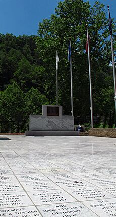
- Veterans Memorial Walk of Honor
- Haysi Kiwanis Park
Education in Haysi
Students in the Haysi area attend Ridgeview High School. Younger students go to Sandlick Elementary School. Both schools are in the nearby community of Birchleaf, Virginia.
Getting Around
Public Transportation
Bus service is available in Haysi and nearby counties. This service is provided by Four County Transit.
Famous People from Haysi
- William Henry McFarland (born 1890), who was a member of the Virginia House of Delegates.
See also
 In Spanish: Haysi para niños
 | Shirley Ann Jackson |
 | Garett Morgan |
 | J. Ernest Wilkins Jr. |
 | Elijah McCoy |


