John W. Flannagan Dam facts for kids
Quick facts for kids John W. Flannagan Dam |
|
|---|---|
 |
|
| Country | United States |
| Location | Dickenson County, Virginia |
| Coordinates | 37°14′00″N 82°20′41″W / 37.23333°N 82.34472°W |
| Purpose | Flood control |
| Status | Operational |
| Construction began | 1960 |
| Opening date | 1964 |
| Owner(s) | U.S. Army Corps of Engineers |
| Dam and spillways | |
| Type of dam | Earth fill |
| Impounds | Pound River |
| Height | 250 ft (76 m) |
| Length | 916 ft (279 m) |
| Reservoir | |
| Creates | John W. Flannagan Reservoir |
| Catchment area | 221 sq mi (570 km2) |
| Surface area | 1,145 acres (463 ha) |
| Normal elevation | 1,396 ft (426 m) |
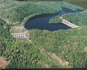
The John W. Flannagan Dam is a special kind of wall built across a river. It helps control floods in the Cumberland Mountains of Dickenson County, Virginia. Behind the dam, a large lake called the John W. Flannagan Reservoir is formed.
Building the Dam: A Look at Its History
The idea for the John W. Flannagan Dam and its reservoir came from laws passed by Congress in 1938 and 1961. These laws aimed to protect people from floods and keep water clean. The U.S. Army Corps of Engineers designed the dam. They also watched over its building and now manage it for everyone's benefit. This dam is an important part of a bigger system that protects the Big Sandy River area from floods.
How the Dam Was Built
Work on the dam started in 1960 and finished in 1964. It's an earth-filled dam, which means it's made mostly of rock and dirt. Inside, it has a special clay core. This clay core acts like a waterproof layer, stopping water from leaking through the dam.
The dam stands about 250 feet (76 m) tall. That's as high as a 25-story building! It stretches 916 feet (279 m) long. The lake behind the dam covers about 1,145-acre (463 ha) of land. It has almost 40 miles (64 km) of shoreline, which is great for exploring.
Near the dam, there's an emergency spillway. This is like a safety valve for the lake. It has six large gates that can open to let out extra water. This stops the lake from getting too full and flowing over the top of the dam during heavy rains. There's also an outlet tunnel with an intake structure. This tall structure has gates that control how much water is released into the Russell Fork River.
What the Dam Does for Us
The main job of the John W. Flannagan Dam is to prevent floods. During the summer, the lake is kept at a certain level, about 1,396 feet (426 m) above sea level. This makes it perfect for fun activities like boating and fishing.
But when fall comes, the lake level is lowered by about 16 feet (4.9 m). This creates extra space to hold water from winter snowmelt and spring rains. When there's a lot of rain, the dam's gates close. This holds back the water that flows into the reservoir from a huge area of 221-square-mile (570 km2). By storing this water, the dam protects homes and towns downstream from flooding.
Once the danger of flooding has passed, the gates are slowly opened. This lets the water out safely. The U.S. Army Corps of Engineers works with other dams on the Big Sandy River and Ohio River to manage water levels. This teamwork helps protect a very large area. The dam has saved millions of dollars in flood damage, much more than the $20 million it cost to build.
The John W. Flannagan Dam area is also a place for outdoor adventures. In October, the dam sometimes releases water for whitewater rafting. This creates exciting rapids on the river below. Some parts of the river, especially in Breaks Interstate Park, have very challenging rapids with names like "20 Stitches" and "Broken Nose."
If you visit, you can also find the John W. Flannagan Boat Dock. It's a marina where you can dock your boat, get gas, buy fishing supplies, and grab a snack.
 | Roy Wilkins |
 | John Lewis |
 | Linda Carol Brown |

