Hancock County, West Virginia facts for kids
Quick facts for kids
Hancock County
|
||
|---|---|---|

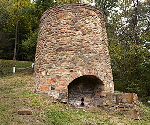
Peter Tarr Furnace Site
|
||
|
||

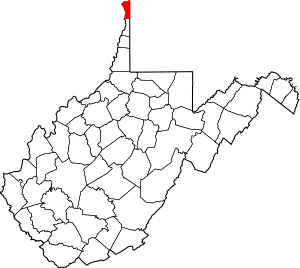
Location within the U.S. state of West Virginia
|
||
 West Virginia's location within the U.S. |
||
| Country | ||
| State | ||
| Founded | January 15, 1848 | |
| Named for | John Hancock | |
| Seat | New Cumberland | |
| Largest city | Weirton | |
| Area | ||
| • Total | 88 sq mi (230 km2) | |
| • Land | 83 sq mi (210 km2) | |
| • Water | 5.4 sq mi (14 km2) 6.1% | |
| Population
(2020)
|
||
| • Total | 29,095 | |
| • Estimate
(2021)
|
28,656 |
|
| • Density | 330.6/sq mi (127.7/km2) | |
| Time zone | UTC−5 (Eastern) | |
| • Summer (DST) | UTC−4 (EDT) | |
| Congressional district | 1st | |
Hancock County is a county in the state of West Virginia. It is located in the northern part of the state. In 2020, about 29,095 people lived there.
The main town, called the county seat, is New Cumberland. The biggest city in the county is Weirton. Hancock County was created in 1848. It was named after John Hancock, who was the first person to sign the Declaration of Independence.
Hancock County is at the very top of West Virginia's "Northern Panhandle." This makes it the northernmost point in West Virginia. It is also considered one of the northernmost points in the Southern United States.
Contents
History of Hancock County
Hancock County was formed in 1848. It was created from a larger area called Brooke County. This happened about 15 years before West Virginia became its own state. Both Hancock and Brooke counties were once part of Ohio County, Virginia.
Early American History
Hancock County has important ties to the American Revolutionary War. This is because of its location near the Ohio River. It was south of Fort Pitt in Pittsburgh. It was also north of Fort Henry in Wheeling.
An important event happened here in 1774. It was called the Yellow Creek massacre. The family of an Iroquois leader named Chief Logan was killed. This event led to a conflict known as Lord Dunmore's War.
Another famous event happened in 1781. A man named Adam Poe had a well-known fight with a Native American known as Big Foot. These events are remembered with special historical markers today. During the Revolutionary War, there were forts and blockhouses in the area. These included Holliday's Cove Fort in Weirton and Chapman's Blockhouse in New Cumberland.
Changes in Local Government
In 1863, West Virginia divided its counties into areas called civil townships. The idea was to help local governments. But this did not work well in the state's rural areas. So, in 1872, the townships became "magisterial districts."
Hancock County was split into four districts: Butler, Clay, Grant, and Poe. The Poe district was the smallest. It was later removed in the 1920s.
Geography of Hancock County
Hancock County covers a total area of about 88 square miles. About 83 square miles of this is land. The remaining 5.4 square miles is water. This means about 6.1% of the county is water.
Hancock County is the smallest county in West Virginia by land area. It is also one of the smallest counties in the entire United States. The highest point in Hancock County is about 1,363 feet high.
Main Roads in Hancock County
 US 22
US 22 US 30
US 30 WV 2
WV 2 WV 8
WV 8 WV 105
Neighboring Counties
Hancock County shares borders with several other counties:
- Columbiana County, Ohio (to the northwest)
- Beaver County, Pennsylvania (to the east)
- Washington County, Pennsylvania (to the southeast)
- Brooke County (to the south)
- Jefferson County, Ohio (to the west)
Population of Hancock County
| Historical population | |||
|---|---|---|---|
| Census | Pop. | %± | |
| 1850 | 4,050 | — | |
| 1860 | 4,445 | 9.8% | |
| 1870 | 4,363 | −1.8% | |
| 1880 | 4,882 | 11.9% | |
| 1890 | 6,414 | 31.4% | |
| 1900 | 6,693 | 4.3% | |
| 1910 | 10,465 | 56.4% | |
| 1920 | 19,975 | 90.9% | |
| 1930 | 28,511 | 42.7% | |
| 1940 | 31,572 | 10.7% | |
| 1950 | 34,388 | 8.9% | |
| 1960 | 39,615 | 15.2% | |
| 1970 | 39,749 | 0.3% | |
| 1980 | 40,418 | 1.7% | |
| 1990 | 35,233 | −12.8% | |
| 2000 | 32,667 | −7.3% | |
| 2010 | 30,676 | −6.1% | |
| 2020 | 29,095 | −5.2% | |
| 2021 (est.) | 28,656 | −6.6% | |
| U.S. Decennial Census 1790–1960 1900–1990 1990–2000 2010–2020 |
|||
2010 Census Information
In 2010, there were 30,676 people living in Hancock County. There were 13,297 households. A household is a group of people living in one home. There were also 8,732 families. The county had about 371 people per square mile.
Most of the people in the county were white (95.7%). About 2.3% were black or African American. Other groups made up smaller percentages. About 1% of the population was of Hispanic or Latino background.
Many people in Hancock County have German, Irish, or Italian family backgrounds. The average age of people in the county was 45.3 years old.
Communities in Hancock County
Cities
- Chester
- New Cumberland (This is the county seat)
- Weirton (Part of this city is in Hancock County)
Magisterial Districts
- Butler
- Clay
- Grant
Census-Designated Place
Unincorporated Communities
Community Population Ranking
The table below shows the population of communities in Hancock County. This information comes from the 2020 census.
† county seat
| Rank | City/Town/etc. | Population (2020 Census) | Population (2021 Estimate) | Municipal type |
|---|---|---|---|---|
| 1 | Weirton partially in Brooke County | 19,163 | 18,813 | City |
| 2 | Chester | 2,208 | 2,173 | City |
| 3 | Newell | 1,203 | -- | CDP |
| 4 | † New Cumberland | 1,020 | 1,007 | City |
See also
 In Spanish: Condado de Hancock (Virginia Occidental) para niños
 | Jessica Watkins |
 | Robert Henry Lawrence Jr. |
 | Mae Jemison |
 | Sian Proctor |
 | Guion Bluford |


