Lawrenceville, West Virginia facts for kids
Quick facts for kids
Lawrenceville, West Virginia
|
|
|---|---|

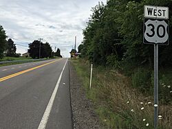
View west along U.S. Route 30 at West Virginia State Route 8 in Lawrenceville
|
|
| Country | United States |
| State | West Virginia |
| County | Hancock |
| Time zone | UTC-5 (Eastern (EST)) |
| • Summer (DST) | UTC-4 (EDT) |
| ZIP codes |
26034
|
| GNIS feature ID | 1554924 |
Lawrenceville is a small community in West Virginia, located in Hancock County. It's not a big city with its own government, but it's right next to the city of Chester. These two places have always been very close. Lawrenceville is also part of the larger Weirton–Steubenville area.
Lawrenceville's Story: A Look Back
Lawrenceville has a long history, starting way back in 1714. That's when people set up a "trading post" there. A trading post was like a small shop where people could buy and sell goods. The community officially became a town in 1814. This happened because the Virginia legislature passed a special law. The Virginia legislature was the government group that made laws for Virginia at that time.
Lawrenceville once had its very own elementary school. But today, students from Lawrenceville go to school in nearby Chester.
Where is Lawrenceville?
Lawrenceville is located in a specific spot that maps show. It's on the East Liverpool South U.S. Geological Survey Map. The community sits at an elevation of 978 feet (about 289 meters) above sea level. This means it's nearly 1,000 feet higher than the ocean! Every place has a special ID code for mapping. Lawrenceville's code is 1554924.
Cool Places to See
 | Emma Amos |
 | Edward Mitchell Bannister |
 | Larry D. Alexander |
 | Ernie Barnes |


