Newell, West Virginia facts for kids
Quick facts for kids
Newell, West Virginia
|
|
|---|---|
 |
|
| Motto(s):
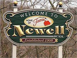
Home of Fiestaware
|
|
| Country | United States |
| State | West Virginia |
| County | Hancock |
| Area | |
| • Total | 0.9 sq mi (2.4 km2) |
| • Land | 0.7 sq mi (1.9 km2) |
| • Water | 0.2 sq mi (0.5 km2) |
| Elevation | 755 ft (230 m) |
| Population
(2020)
|
|
| • Total | 1,203 |
| • Density | 1,340/sq mi (501/km2) |
| Time zone | UTC-5 (Eastern (EST)) |
| • Summer (DST) | UTC-4 (EDT) |
| ZIP code |
26050
|
| Area code(s) | 304 |
| FIPS code | 54-58420 |
| GNIS feature ID | 1558378 |
Newell is a small community in northern West Virginia, located right next to the Ohio River. In 2020, about 1,200 people lived there. It's famous for being the home of the Fiesta Tableware Company, which makes colorful dishes! Newell is part of a larger area called the Weirton–Steubenville metropolitan area.
Contents
Newell's Early History and Growth
The area where Newell is today has an interesting past. Long ago, a small town called Hamilton was planned nearby by William Hamilton. Later, in the 1800s, a man named Hugh Newell became the owner of the land. His family, the Newells, owned the land for many years.
How Newell Became a Town
In 1891, a group of business people from Pittsburgh bought land from the Newell family and others. They wanted to build a large industrial area there. The town of Newell was officially planned in 1902 by the North American Manufacturing Company.
The Famous Pottery Factory
A very important event happened in 1905. The Homer Laughlin China Company, which was across the Ohio River in East Liverpool, Ohio, decided to build a huge pottery factory in Newell. At the time, it was the biggest pottery factory in the world! To connect the two towns, the Newell Toll Bridge was built across the river.
After the factory opened, Newell grew very quickly. A school was built in 1907. More factories, including places that made pottery, tiles, and special heat-resistant materials, opened in the 1910s and 1920s.
Historic Places in Newell
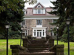
Newell is home to some important historical sites. The Waterford Park (which is now called Mountaineer Casino, Racetrack and Resort) and the William E. Wells House are both listed on the National Register of Historic Places. This means they are recognized as special places that are important to history.
Newell's Location and Size
Newell is located at coordinates 40.617544 degrees North and -80.600856 degrees West. It sits right along the Ohio River.
Neighboring Towns
To the south of Newell, you'll find the city of New Cumberland. To the east is the city of Chester. If you go north across the Wayne Six Toll Bridge, you'll reach East Liverpool, Ohio.
How Big is Newell?
Newell covers an area of about 0.9 square miles (2.4 square kilometers). Most of this area is land, about 0.8 square miles (1.9 square kilometers). The rest, about 0.2 square miles (0.5 square kilometers), is water, mostly from the Ohio River.
Newell's Population Over Time
| Historical population | |||
|---|---|---|---|
| Census | Pop. | %± | |
| 1980 | 2,032 | — | |
| 1990 | 1,724 | −15.2% | |
| 2000 | 1,602 | −7.1% | |
| 2010 | 1,376 | −14.1% | |
| 2020 | 1,203 | −12.6% | |
| U.S. Decennial Census | |||
In 2000, there were about 1,600 people living in Newell. By 2020, the population was 1,203.
Schools in Newell
Children living in Newell attend schools that are part of the Hancock County School District.
The schools serving Newell are:
- Allen T. Allison Elementary School – for students in grades K-4
- Oak Glen Middle School – for students in grades 5-8
- Oak Glen High School – for students in grades 9-12
See also
 In Spanish: Newell (Virginia Occidental) para niños
 | Sharif Bey |
 | Hale Woodruff |
 | Richmond Barthé |
 | Purvis Young |


