Fort Steuben facts for kids
Fort Steuben was a military fort built in February 1787. It stood on the Ohio River in what is now eastern Ohio. The fort was located where the city of Steubenville, Ohio is today.
Major John Hamtramck built the fort. He named it after Friedrich Wilhelm von Steuben, a brave army officer from Prussia. Steuben had served with General Washington during the American Revolutionary War. The fort's main job was to protect the first land surveyors. These surveyors were exploring the Northwest Territory and needed safety from Native American groups.
Contents
Building a New Nation: The Ohio Country
After the American Revolutionary War ended in 1783, the United States claimed a large area called the Ohio Country. This land had been controlled by Great Britain before the war. The U.S. government wanted to survey, sell, and settle this new territory. They also hoped to earn money from the land sales.
Surveying the Land: The Seven Ranges
In 1785, the U.S. Congress passed the Land Ordinance of 1785. This law set up a plan to measure and divide the land. The survey was supposed to start near East Liverpool, Ohio, where the Ohio River leaves Pennsylvania. From there, surveyors would work their way west into what is now Ohio.
Thomas Hutchins, the Geographer of the United States, began the survey in September 1785. However, after only a few miles, his team heard about a Native American attack. Frightened, they returned to Pittsburgh. Hutchins went back to New York that autumn.
Protecting the Surveyors: Fort Harmar and Fort Steuben
In July 1786, Hutchins and his team tried again. They gathered in Pittsburgh, Pennsylvania. A fort called Fort Harmar had been built further south, where the Muskingum River meets the Ohio River. Hutchins asked for soldiers to protect his surveyors.
Colonel Josiah Harmar sent Major John Francis Hamtramck and some soldiers from the First American Regiment. Major Hamtramck realized they needed a new fort. This fort would protect the surveyors and stop people from illegally settling on the land.
Building Fort Steuben
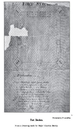
The perfect spot for the new fort was chosen on October 11, 1786. Major Erkuries Beatty, who drew a picture of the fort, described it. He said it was about 47 miles below Fort McIntosh. It was on a high, strong bank, about 120 yards from the river.
What Fort Steuben Looked Like
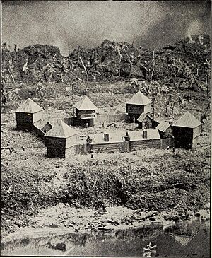
Major Beatty described Fort Steuben as a square-shaped fort. It had a large blockhouse at each corner. Blockhouses were strong buildings used for defense. Wooden fences, called pickets, connected the blockhouses.
The main gate faced west, and a smaller gate, called a sally port, faced the river. The soldiers lived in the blockhouses. The officers' houses were on either side of the main gate. The back walls of these houses also acted as part of the fort's picket fence.
Life at the Fort
Captain Hamtramck's and Captain Mercer's companies of soldiers lived at Fort Steuben. Hamtramck was in charge. He officially named the fort after Baron von Steuben on January 2, 1787. The fort was finished just a few days later, on January 8.
By May 1787, the surveyors had moved closer to Fort Harmar. So, Major Hamtramck and his soldiers were ordered to leave Fort Steuben. The troops moved to Fort Harmar, and supplies went to Fort Henry in Wheeling.
The End of the Fort and a New Beginning
Fort Steuben was destroyed by fire in 1790 and was never rebuilt. Years later, in 1797, a man named Bezaleel Wells founded the city of Steubenville on the same spot.
Today, you can visit a replica of Fort Steuben. There's also a visitors center and the original Steubenville Federal Land Office. It's a great place to learn about this important part of American history!
See also
 | Janet Taylor Pickett |
 | Synthia Saint James |
 | Howardena Pindell |
 | Faith Ringgold |


