Seven Ranges Terminus facts for kids
Quick facts for kids |
|
|
Seven Ranges Terminus
|
|

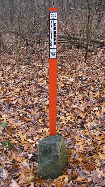
The marker with a modern surveying marker
|
|
| Nearest city | Magnolia, Ohio |
|---|---|
| Built | August 10, 1786 |
| NRHP reference No. | 76001527 |
| Added to NRHP | December 12, 1976 |
The Seven Ranges Terminus is a special stone marker located near Magnolia, Ohio. It's super important because it marks the very first step in opening up a huge area of land for sale and settlement by Americans after the American Revolutionary War. This marker shows where the first ever land survey using a grid system, like a giant checkerboard, was completed. This new way of dividing land helped people buy and settle new areas.
Contents
History of the Seven Ranges Terminus
Winning the War and Gaining Land
After winning the American Revolutionary War, the United States signed the Treaty of Paris (1783). This treaty gave the U.S. a large area of land. This land was north of the Ohio River, south of the Great Lakes, and east of the Mississippi River. It was called the Northwest Territory.
Planning How to Divide Land
The U.S. Congress, under the Articles of Confederation, needed a way to organize this new land. They wanted to survey it, sell it, and help people settle there. So, in 1785, they passed a law called the Land Ordinance of 1785.
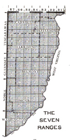
This law created a new system for surveying land. It divided the land into a grid of squares, each six miles by six miles. These squares were called "survey townships." These townships were then grouped into vertical rows called "Ranges."
How the Survey System Worked
The first ranges were measured from a special north-south line. This line was located along the western border of Pennsylvania. The townships in each range were measured from an east-west line. This line was called a "baseline." This system was the beginning of the Public Land Survey System we still use today.
Starting the First Survey
The 1785 law said that Thomas Hutchins, the Geographer of the United States, had to lead the first survey himself. He was supposed to find a "Point of Beginning" on the north bank of the Ohio River. This was where the river leaves Pennsylvania.
From that point, he had to create a baseline that was seven ranges wide, which is 42 miles. This line was called the "Geographer's Line." Then, he had to survey north-south lines every six miles. These lines would mark the edges of the ranges. He also had to mark the southern border of each township.
After each set of seven ranges was finished, Hutchins had to send maps back to the government. This allowed the government to sell the land.
Challenges and Completion
Hutchins started surveying the Geographer's Line in 1785. He worked with important surveyors from ten different states. But they had to stop after only a few miles. There were problems with Native American groups in the area.
In 1786, Hutchins started the survey again. This time, soldiers from Fort Steuben protected his team. In September 1786, Hutchins placed a stone marker. This marker was at the western edge of the seventh range on the Geographer's Line. This spot later became known as the Seven Ranges Terminus. After the first seven ranges were fully surveyed, the area became known as the Seven Ranges, or the Old Seven Ranges.
The Survey Marker Itself
This important survey marker is located where four townships meet. It also marks the corner of three counties and three different survey areas:
- Rose Township, Carroll County, Ohio (Township 16, Range 7 of Old Seven Ranges)
- Sandy Township, Stark County, Ohio (Township 17, Range 7 of Congress Lands North of Old Seven Ranges)
- Pike Township, Stark County, Ohio (Township 8, Range 8 of Congress Lands North of Old Seven Ranges)
- Sandy Township, Tuscarawas County, Ohio (Township 10, Range 1 of United States Military District)
The marker belongs to the U.S. government. However, it is surrounded by private land. It sits about 288 feet west of a public road.
The marker is made of granite. It is six inches square at the top and has an "X" carved into it. About a foot of the stone sticks out of the ground, but much more is buried deep below. A newspaper, The Repository, reported in 2003 that the stone leans a bit. This might be because someone tried to dig it up years ago. Another reason could be that the ground has frozen and thawed over two centuries, causing it to shift.
The Seven Ranges Terminus was added to the National Register of Historic Places in 1976. This was because of its important connection to Thomas Hutchins and the history of land surveying in the United States.
 | Valerie Thomas |
 | Frederick McKinley Jones |
 | George Edward Alcorn Jr. |
 | Thomas Mensah |


