Bucks County, Pennsylvania facts for kids
Quick facts for kids
Bucks County
|
|||||
|---|---|---|---|---|---|
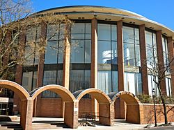
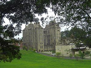
Bucks County Administration Building in Doylestown in 2010
|
|||||
|
|||||
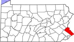
Location within the U.S. state of Pennsylvania
|
|||||
 Pennsylvania's location within the U.S. |
|||||
| Country | |||||
| State | |||||
| Founded | November 1682 | ||||
| Named for | Buckinghamshire, England | ||||
| Seat | Doylestown | ||||
| Largest township | Bensalem | ||||
| Area | |||||
| • Total | 622 sq mi (1,610 km2) | ||||
| • Land | 604 sq mi (1,560 km2) | ||||
| • Water | 18 sq mi (50 km2) 2.8%% | ||||
| Population
(2020)
|
|||||
| • Total | 646,538 | ||||
| • Estimate
(2023)
|
645,984 |
||||
| • Density | 1,070/sq mi (410/km2) | ||||
| Time zone | UTC−5 (Eastern) | ||||
| • Summer (DST) | UTC−4 (EDT) | ||||
| Congressional district | 1st | ||||
|
Pennsylvania Historical Marker
|
|||||
| Designated: | October 29, 1982 | ||||
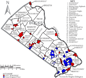
Bucks County is a county in the state of Pennsylvania. In 2020, about 646,538 people lived here. This makes it the fourth-most populated county in Pennsylvania. The main town where the county government is located is Doylestown.
The county got its name from Buckinghamshire, a county in England. Bucks County is part of the Southeast Pennsylvania region. It is also part of the larger Philadelphia metropolitan area. Bucks County borders Montgomery County and Philadelphia to the southwest. To the east, it borders the Delaware River and the state of New Jersey. To the north, it borders Lehigh and Northampton counties.
Contents
- History of Bucks County
- Geography and Landscape
- Population and People
- Economy and Jobs
- Education in Bucks County
- Libraries
- Arts and Culture
- Media
- Sports and Recreation
- Parks and Outdoor Fun
- Getting Around: Transportation
- Towns and Communities
- Climate and Weather
- Notable People from Bucks County
- Official Seal of Bucks County
- See also
History of Bucks County
How Was Bucks County Founded?
Bucks County is one of the first three counties created by William Penn in 1682. Penn was the founder of Pennsylvania. He named the county after Buckinghamshire, the place where he lived in England. "Bucks." is a short way to say Buckinghamshire.
William Penn built his country home, Pennsbury Manor, in what is now Falls Township. Many places in Bucks County are named after spots in England. For example, Buckingham and Buckingham Township are named after the old county town of Buckinghamshire.
Chalfont is named after Chalfont St Giles, where William Penn's first wife lived. Penn is also buried there. Solebury is named after Soulbury, England. Wycombe is named after High Wycombe.
Bucks County used to be much bigger. In 1752, Northampton County was formed from part of Bucks County. Later, in 1812, Lehigh County was formed from part of Northampton County.
Bucks County During the American Revolutionary War
During the American Revolutionary War, General George Washington and his soldiers camped in Bucks County. They were getting ready to cross the Delaware River. Their plan was to surprise the British Hessian forces in Trenton, New Jersey.
This famous crossing happened on the morning of December 26, 1776. Their successful attack was a major turning point in the war. The town of Washington Crossing, Pennsylvania and Washington Crossing Historic Park are named to remember this important event.
Geography and Landscape
Bucks County covers about 622 square miles. Most of this area, 604 square miles, is land. The remaining 18 square miles (2.8%) is water.
The southern part of the county is called Lower Bucks. It is located between Philadelphia and Trenton, New Jersey. This area is flat and close to sea level. It is the most populated and industrial part of the county.
Bucks County shares borders with several other counties. To the west, it borders Montgomery County. To the southwest, it borders Philadelphia. To the north, it borders Northampton and Lehigh counties.
Many bridges connect Bucks County to New Jersey counties. These include Warren, Hunterdon, Mercer, and Burlington counties.
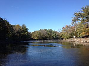
The two largest streams in Bucks County are Tohickon Creek and Neshaminy Creek. They both flow into the Delaware River. Tohickon Creek joins the river at Point Pleasant. Neshaminy Creek joins it at Croydon.
Neighboring Counties
- Lehigh County (northwest)
- Northampton County (north)
- Warren County, New Jersey (northeast)
- Hunterdon County, New Jersey (northeast)
- Mercer County, New Jersey (east)
- Burlington County (southeast)
- Philadelphia County (south)
- Montgomery County (west)
Population and People
| Historical population | |||
|---|---|---|---|
| Census | Pop. | %± | |
| 1790 | 25,216 | — | |
| 1800 | 27,496 | 9.0% | |
| 1810 | 32,371 | 17.7% | |
| 1820 | 37,842 | 16.9% | |
| 1830 | 45,745 | 20.9% | |
| 1840 | 48,107 | 5.2% | |
| 1850 | 56,091 | 16.6% | |
| 1860 | 63,578 | 13.3% | |
| 1870 | 64,336 | 1.2% | |
| 1880 | 68,656 | 6.7% | |
| 1890 | 70,615 | 2.9% | |
| 1900 | 71,190 | 0.8% | |
| 1910 | 76,530 | 7.5% | |
| 1920 | 82,476 | 7.8% | |
| 1930 | 96,727 | 17.3% | |
| 1940 | 107,715 | 11.4% | |
| 1950 | 144,620 | 34.3% | |
| 1960 | 308,567 | 113.4% | |
| 1970 | 410,056 | 32.9% | |
| 1980 | 479,211 | 16.9% | |
| 1990 | 541,174 | 12.9% | |
| 2000 | 597,635 | 10.4% | |
| 2010 | 625,249 | 4.6% | |
| 2020 | 646,538 | 3.4% | |
| U.S. Decennial Census 1790-1960 1900-1990 1990-2000 2010-2019 |
|||
In 2010, there were 625,249 people living in Bucks County. The population density was about 1,034 people per square mile. Most people were white (86.6%). Other groups included Black or African American (3.9%) and Asian (4.1%). About 4.4% of the population was Hispanic or Latino.
In 2000, there were 218,725 households. About 35.3% of these households had children under 18. The average household had 2.69 people. The average family had 3.17 people.
The median income for a household in 2000 was $59,727. For a family, it was $68,727. About 4.5% of the population lived below the poverty line. This included 4.8% of those under 18.
How Bucks County Grew
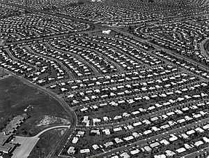
Growth in Bucks County started in the early 1950s. This was when William Levitt chose the area for his second "Levittown." Levitt bought many acres of land. He built 17,000 homes, schools, parks, libraries, and shopping centers. Levittown's population quickly grew to almost 74,000 residents.
At first, only white people could buy homes in Levittown. However, this rule was soon changed. Other planned communities like Croydon and Fairless Hills also grew rapidly. This fast growth continued until the mid-1960s.
In the 1970s, the county grew even more. Developers built in areas that were not developed before. These included Middletown, Lower Makefield, and Newtown townships. New homes, offices, and shopping centers spread across the county. This development moved more towards Upper Bucks. It changed many farms, forests, and wetlands. Oxford Valley Mall was built in Middletown. It became a major shopping spot.
By the late 20th century, growth slowed down. This was because most of the undeveloped areas had been built on. Areas along the Delaware River used to have many factories. Now, many of these old industrial sites are being turned into luxury homes. Older areas like Levittown are also changing. Old shops are being replaced with new shopping centers. Central and Upper Bucks continue to grow quickly. Many towns there have doubled their populations since the late 1900s.
In 2013, Bucks County had 626,976 people. It was the fourth-most populated county in Pennsylvania.
Bucks County Population in 2020
| Race | Num. | Perc. |
|---|---|---|
| White (NH) | 521,575 | 80.67% |
| Black or African American (NH) | 25,277 | 4% |
| Native American (NH) | 531 | 0.08% |
| Asian (NH) | 35,053 | 5.42% |
| Pacific Islander (NH) | 143 | 0.02% |
| Other/Mixed (NH) | 24,189 | 3.74% |
| Hispanic or Latino | 39,770 | 6.15% |
Economy and Jobs
The towns of Bristol and Morrisville were important industrial centers during World War II. These towns are along the Northeast Corridor train line.
In the 1950s, suburban growth sped up in Lower Bucks. This was after Levittown, Pennsylvania opened. It was the second "Levittown" community designed by William Levitt.
Some of the biggest employers in Bucks County in the 20th century included U.S. Steel in Falls Township. Also, Vulcanized Rubber & Plastics and Robertson Tile companies in Morrisville. Rohm and Haas still runs several chemical plants near Bristol.
Waste Management operates a large landfill in Tullytown. This landfill receives a lot of trash from outside the state, including much of New York City's waste.
Bucks County is also seeing fast growth in biotechnology. This is the study of using living things to make products. The greater Philadelphia area is one of the top places for biotechnology and biopharma companies. It is expected that by 2020, one out of four people in Bucks County will work in biotechnology.
Well-Known Businesses in Bucks County
- 21st Century Media
- Burpee Seeds and Plants
- Byers' Choice Ltd.
- Carson Helicopters
- Charming Shoppes
- EPAM Systems
- GE Betz
- Lehigh Defense
- McCaffrey's Food Markets
- New Hope and Ivyland Railroad
- Rita's Italian Ice
- Simpay
- West Coast Video
Fun Things to Do: Tourism
Tourism is also a big part of the county's economy. The northern parts of the county, called Upper Bucks, are known for their beautiful nature. They have farmlands and lots of history from colonial times. They are also close to big cities like Philadelphia, New York City, and Allentown. All these cities are within a two-hour drive.
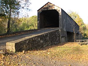
Bucks County has twelve covered bridges. Ten of them are still used by cars. Two are in parks and are only for walking or biking. All these bridges use a special design called the Town truss. The Schofield Ford Bridge in Tyler State Park was rebuilt in 1997. It had been destroyed by fire in 1991.
Popular places to visit in Bucks County include the shops in New Hope. Also, Peddler's Village in Lahaska, and Washington Crossing Historic Park. You can also ride the New Hope Railroad or visit the Bucks County Playhouse Theater in New Hope.
In Doylestown, the county seat, you can see three unique buildings made by Henry Chapman Mercer. These are the Moravian Pottery and Tile Works, the Mercer Museum, and Fonthill. Fonthill was Mercer's own home.
Lower Bucks County has two large shopping malls: Neshaminy Mall and Oxford Valley Mall. It is also home to Sesame Place. This is a family theme park based on the Sesame Street TV show. Another popular spot in Lower Bucks is Parx Casino and Racing in Bensalem. It has a casino and thoroughbred horse racing.
Education in Bucks County
Colleges and Universities
- Bucks County Community College
- Delaware Valley University in Doylestown
- Cairn University in Langhorne Manor
- Holy Family University in Newtown
- La Salle University in Newtown
- Strayer University in Trevose
Public School Districts
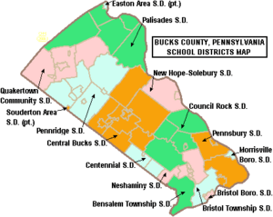
Here are some of the public school districts in Bucks County:
- Bensalem Township School District
- Bristol Borough School District
- Bristol Township School District
- Centennial School District
- Central Bucks School District
- Council Rock School District
- Morrisville Borough School District
- Neshaminy School District
- New Hope-Solebury School District
- Palisades School District
- Pennridge School District
- Pennsbury School District
- Quakertown Community School District
These schools get support from the Bucks County Intermediate Unit #22. This agency is located in Doylestown.
Public Charter Schools
- Bucks County Montessori Charter School
- Center Student Learning Charter School
- School Lane Charter School
Private Schools
- Archbishop Wood Catholic High School
- Calvary Christian School
- Conwell-Egan Catholic High School
- George School
- Holy Ghost Preparatory School (for boys)
- Newtown Friends School
- Plumstead Christian School
- Quakertown Christian School
- Solebury School
- Villa Joseph Marie High School (for girls)
Technical and Community Colleges
- Bucks County Community College
- Bucks County School of Beauty Culture
- Bucks County Technical High School
- Cairn University
- CHI Institute
- Delaware Valley University
- Holy Family University
- Middle Bucks Institute of Technology
- Pennco Tech
Libraries
The Bucks County Library System started in 1956. It has 7 branch libraries in different towns:
- Bensalem
- Doylestown
- Langhorne
- Levittown
- Perkasie
- Quakertown
- Yardley-Makefield
Arts and Culture
Fine and Performing Arts
Many famous artists and writers from New York City have lived in Bucks County. They often settled near Doylestown and New Hope, along the Delaware River. Some well-known people who lived here include Pearl S. Buck, Oscar Hammerstein II, Stephen Sondheim, and James Michener.
Bucks County has many local theater groups. These include the Bucks County Playhouse in New Hope, Town and Country Players in Buckingham, and the Bristol Riverside Theatre. The Bucks County Symphony, started in 1953, performs in Doylestown. The Bucks County Gilbert & Sullivan Society performs an operetta every June.
Movies Filmed in Bucks County
Many movies and TV shows have been filmed or set in Bucks County:
- The 2019 film Colewell was dedicated to Marguerite Addis, a lifelong resident of Bucks County.
- The 2012 film Safe, starring Jason Statham, was filmed at Parx Casino and Racing in Bensalem Township.
- The 2012 film The Discoverers was filmed in many Bucks County locations. These include Croydon, Bristol, Newtown, New Hope, and Tyler State Park.
- The 2010 TV pilot for Outlaw was filmed in the Andalusia area of Bensalem Township.
- Bucks County is mentioned in the 2010 TV series Pretty Little Liars.
- The 2009 film Law Abiding Citizen, starring Gerard Butler and Jamie Foxx, was partly filmed in New Hope.
- The county fair scene in the 2006 film Charlotte's Web was filmed at the Southampton Days Fair.
- M. Night Shyamalan's 2002 film Signs, starring Mel Gibson, was filmed and takes place in Bucks County. The town scenes were filmed in Newtown Borough. The house was built on land in Doylestown Township.
- Shyamalan's 2008 film, The Happening, was filmed in Upper Bucks County. This included Plumsteadville.
- The 1998 film The Last Broadcast was mostly shot in Bucks County.
- One of Steven Spielberg's early films, Something Evil (1972), is set in Bucks County.
Media
Local newspapers and online news sources in Bucks County include:
- Bucks County Courier Times
- The Intelligencer
- The Advance of Bucks County
- Levittown Now
- Bucks County Beacon
- NewtownPANow
- Bucks Happening
- New Hope Free Press
WBCB is a local radio news station.
Sports and Recreation
Rugby League
The Bucks County Sharks rugby league team played in the AMNRL from 1997 to 2010. They joined the USARL in 2014.
Little League Baseball
Bucks County has a strong history in Little League baseball. Since 1947, four of the seven Pennsylvania teams that played in the Little League World Series came from Bucks County. These were Morrisville (1955), Levittown American (1960 and 1961), and Council Rock-Newtown (2005). Two of these teams, Morrisville and Levittown (1960), won the World Series title!
Horse Racing
- Parx Casino and Racing, in Bensalem, is a famous horse racing track. It was once home to Smarty Jones, a horse that competed in the Triple Crown of Thoroughbred Racing.
Parks and Outdoor Fun
Pennsylvania State Parks
Bucks County has six state parks:
- Five parks are run by the Pennsylvania Bureau of State Parks. These are:
- Bucks County Parks and Recreation also runs a youth hostel in Nockamixon State Park.
- Washington Crossing Historic Park is a 500-acre site. It is run by the Pennsylvania Historical and Museum Commission. This park marks the spot where George Washington's crossing of the Delaware River happened during the American Revolutionary War.
County Parks
Bucks County has many county parks for everyone to enjoy:
- Bucks County Horse Park
- Core Creek Park
- Dark Hollow Park
- Lake Towhee Park
- Peace Valley Park
- Playwicki Park
- Ringing Rocks Park
- Silver Lake Park
- Tinicum Park
- Tohickon Valley Park
Historic Places to Visit
- Moravian Pottery and Tile Works
- Moland House is an old stone farmhouse built around 1750. General George Washington used it as his headquarters in 1777.
- Summerseat in Morrisville was built around 1765. It was owned by two signers of the Declaration of Independence. George Washington also used it as his headquarters in 1776.
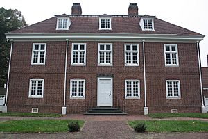
- Pennsbury Manor was the home of William Penn, the founder of Pennsylvania. You can visit the house and grounds.
- African American Museum of Bucks County
County Recreation Spots
- Frosty Hollow Tennis Center
- Core Creek Tennis Center
- Oxford Valley Golf Course
- Oxford Valley Pool
- Tohickon Valley Pool
- Weisel Hostel
- Peace Valley Boat Rental
- Core Creek Boat Rental
Nature Centers
- Bucks County Audubon Society's Honey Hollow Environmental Education Center
- Churchville Nature Center
- Clark Nature Center
- Peace Valley Nature Center
- Silver Lake Nature Center
Getting Around: Transportation
Airports
There are several airports in or near Bucks County:
- Doylestown Airport
- Pennridge Airport
- Philadelphia International Airport
- Quakertown Airport
- Sterling Aviation Heliport in Croydon
- Van Sant Airport and Park
- Trenton-Mercer Airport
Public Transportation
- Amtrak trains run through southern Bucks County. The Keystone Service stops at the Cornwells Heights station in Bensalem Township.
- Bucks County Transport offers ridesharing services.
- Doylestown Dart provides public transportation around Doylestown.
- SEPTA (Southeastern Pennsylvania Transportation Authority) has:
- Bus routes across southeastern Bucks County.
- Regional Rail lines like the Lansdale/Doylestown and Trenton lines.
- TMA Bucks's Rushbus runs in parts of southern and central Bucks County.
Major Roads and Highways
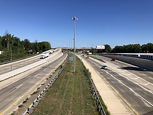
Major roads that go through Bucks County include:
 I-95
I-95
 I-276 / Penna Turnpike (Pennsylvania Turnpike)
 I-295
I-295 US 1
US 1 US 13
US 13 US 202
 PA 32
PA 32 PA 63
PA 63 PA 113
 PA 213
 PA 263
 PA 309
 PA 313
 PA 413
 PA 532
 PA 611
Towns and Communities
Pennsylvania has different types of towns. Bucks County has boroughs and townships. The largest borough is Morrisville.
Boroughs (Towns)
- Bristol
- Chalfont
- Doylestown (the main county town)
- Dublin
- Hulmeville
- Ivyland
- Langhorne
- Langhorne Manor
- Morrisville
- New Britain
- New Hope
- Newtown
- Penndel
- Perkasie
- Quakertown
- Richlandtown
- Riegelsville
- Sellersville
- Silverdale
- Telford (partly in Montgomery County)
- Trumbauersville
- Tullytown
- Yardley
Townships
- Bedminster
- Bensalem
- Bridgeton
- Bristol
- Buckingham
- Doylestown
- Falls
- Hilltown
- Lower Makefield
- Middletown
- Newtown
- Northampton
- Plumstead
- Solebury
- Upper Makefield
- Warminster
- Warrington
- Warwick
Census-Designated Places (CDPs)
These are areas the U.S. Census Bureau uses for data. They are not official towns.
- Brittany Farms-The Highlands
- Churchville
- Cornwells Heights
- Croydon
- Fairless Hills
- Feasterville
- Levittown
- Newtown Grant
- Plumsteadville
- Richboro
- Trevose
- Village Shires
- Warminster Heights
- Woodbourne
- Woodside
Unincorporated Communities
These are smaller communities that are not officially part of a borough or township.
- Andalusia
- Blooming Glen
- Buckingham
- Carversville
- Fallsington
- Furlong
- Holland
- Jamison
- Lahaska
- Lumberville
- Mechanicsville
- Oxford Valley
- Pipersville
- Point Pleasant
- Southampton
- Washington Crossing
- Wycombe
Largest Communities by Population (2010 Census)
† county seat
| Rank | City/Town/etc. | Municipal type | Population (2010 Census) |
|---|---|---|---|
| 1 | Bensalem | Township | 60,427 |
| 2 | Levittown | CDP | 52,983 |
| 3 | Croydon | CDP | 9,950 |
| 4 | Bristol | Borough | 9,726 |
| 5 | Quakertown | Borough | 8,979 |
| 6 | Morrisville | Borough | 8,728 |
| 7 | Perkasie | Borough | 8,511 |
| 8 | Fairless Hills | CDP | 8,466 |
| 9 | † Doylestown | Borough | 8,380 |
| 10 | Richboro | CDP | 6,563 |
Climate and Weather
Piedmont Region Climate
The northern part of Bucks County, called the Piedmont region, has a climate with hot, slightly humid summers and cold winters. It rains all year. In summer, it can get very hot and humid. In winter, it can be very cold and windy. The average snowfall from November to April is between 26 and 36 inches. February is usually the snowiest month.
| Climate data for Haycock Twp. Elevation: 735 ft. 1981-2010 Averages (1981-2018 Records) | |||||||||||||
|---|---|---|---|---|---|---|---|---|---|---|---|---|---|
| Month | Jan | Feb | Mar | Apr | May | Jun | Jul | Aug | Sep | Oct | Nov | Dec | Year |
| Record high °F (°C) | 69.9 (21.1) |
77.8 (25.4) |
86.8 (30.4) |
93.1 (33.9) |
93.9 (34.4) |
94.5 (34.7) |
101.4 (38.6) |
98.6 (37.0) |
96.3 (35.7) |
88.9 (31.6) |
79.6 (26.4) |
73.7 (23.2) |
101.4 (38.6) |
| Mean daily maximum °F (°C) | 37.3 (2.9) |
41.1 (5.1) |
49.1 (9.5) |
61.3 (16.3) |
71.0 (21.7) |
79.2 (26.2) |
83.5 (28.6) |
81.9 (27.7) |
75.2 (24.0) |
64.1 (17.8) |
53.4 (11.9) |
41.7 (5.4) |
61.7 (16.5) |
| Daily mean °F (°C) | 28.4 (−2.0) |
31.4 (−0.3) |
38.7 (3.7) |
49.9 (9.9) |
59.7 (15.4) |
68.4 (20.2) |
72.8 (22.7) |
71.4 (21.9) |
64.3 (17.9) |
53.3 (11.8) |
43.7 (6.5) |
33.2 (0.7) |
51.4 (10.8) |
| Mean daily minimum °F (°C) | 19.5 (−6.9) |
21.7 (−5.7) |
28.4 (−2.0) |
38.4 (3.6) |
48.3 (9.1) |
57.7 (14.3) |
62.1 (16.7) |
60.9 (16.1) |
53.4 (11.9) |
42.5 (5.8) |
34.0 (1.1) |
24.7 (−4.1) |
41.1 (5.1) |
| Record low °F (°C) | −13.9 (−25.5) |
−6.5 (−21.4) |
0.7 (−17.4) |
15.9 (−8.9) |
31.4 (−0.3) |
39.4 (4.1) |
45.4 (7.4) |
40.2 (4.6) |
33.8 (1.0) |
22.7 (−5.2) |
9.8 (−12.3) |
−3.5 (−19.7) |
−13.9 (−25.5) |
| Average precipitation inches (mm) | 3.54 (90) |
2.89 (73) |
3.74 (95) |
4.25 (108) |
4.24 (108) |
4.34 (110) |
5.11 (130) |
4.12 (105) |
4.45 (113) |
4.56 (116) |
3.83 (97) |
4.20 (107) |
49.27 (1,251) |
| Average relative humidity (%) | 68.6 | 64.5 | 60.7 | 58.9 | 64.0 | 70.4 | 69.9 | 72.5 | 73.4 | 71.7 | 69.6 | 70.1 | 67.9 |
| Average dew point °F (°C) | 19.4 (−7.0) |
20.8 (−6.2) |
26.3 (−3.2) |
36.1 (2.3) |
47.5 (8.6) |
58.4 (14.7) |
62.4 (16.9) |
62.1 (16.7) |
55.6 (13.1) |
44.4 (6.9) |
34.4 (1.3) |
24.5 (−4.2) |
41.1 (5.1) |
| Source: PRISM | |||||||||||||
| Climate data for Doylestown, Pennsylvania | |||||||||||||
|---|---|---|---|---|---|---|---|---|---|---|---|---|---|
| Month | Jan | Feb | Mar | Apr | May | Jun | Jul | Aug | Sep | Oct | Nov | Dec | Year |
| Mean daily maximum °F (°C) | 39 (4) |
43 (6) |
52 (11) |
63 (17) |
74 (23) |
82 (28) |
87 (31) |
85 (29) |
77 (25) |
66 (19) |
55 (13) |
44 (7) |
64 (18) |
| Mean daily minimum °F (°C) | 24 (−4) |
25 (−4) |
33 (1) |
42 (6) |
52 (11) |
61 (16) |
66 (19) |
65 (18) |
57 (14) |
45 (7) |
37 (3) |
29 (−2) |
45 (7) |
| Average precipitation inches (mm) | 3.94 (100) |
2.87 (73) |
4.24 (108) |
3.85 (98) |
4.81 (122) |
3.61 (92) |
4.72 (120) |
4.34 (110) |
4.66 (118) |
3.35 (85) |
3.74 (95) |
3.80 (97) |
47.93 (1,217) |
| Source: Weather Channel | |||||||||||||
Atlantic Coastal Plain Region Climate
The southern part of Bucks County, the Atlantic Coastal Plain, has hot, slightly humid summers and cool winters. It also rains all year. In summer, it can get very hot and humid. In winter, it can be very cold and windy. The average snowfall from November to April is between 24 and 26 inches. February is usually the snowiest month.
| Climate data for Andalusia, Bensalem Twp. Elevation: 16 ft. 1981-2010 Averages (1981-2018 Records) | |||||||||||||
|---|---|---|---|---|---|---|---|---|---|---|---|---|---|
| Month | Jan | Feb | Mar | Apr | May | Jun | Jul | Aug | Sep | Oct | Nov | Dec | Year |
| Record high °F (°C) | 72.5 (22.5) |
78.7 (25.9) |
87.7 (30.9) |
94.1 (34.5) |
96.1 (35.6) |
97.5 (36.4) |
103.5 (39.7) |
101.3 (38.5) |
99.1 (37.3) |
89.6 (32.0) |
81.8 (27.7) |
76.6 (24.8) |
103.5 (39.7) |
| Mean daily maximum °F (°C) | 41.0 (5.0) |
44.4 (6.9) |
52.6 (11.4) |
63.9 (17.7) |
73.7 (23.2) |
82.9 (28.3) |
86.9 (30.5) |
85.5 (29.7) |
78.7 (25.9) |
67.3 (19.6) |
56.4 (13.6) |
45.4 (7.4) |
65.0 (18.3) |
| Daily mean °F (°C) | 33.4 (0.8) |
36.0 (2.2) |
43.3 (6.3) |
53.8 (12.1) |
63.3 (17.4) |
72.8 (22.7) |
77.4 (25.2) |
76.0 (24.4) |
68.9 (20.5) |
57.3 (14.1) |
47.6 (8.7) |
37.8 (3.2) |
55.7 (13.2) |
| Mean daily minimum °F (°C) | 25.6 (−3.6) |
27.6 (−2.4) |
34.1 (1.2) |
43.6 (6.4) |
52.9 (11.6) |
62.7 (17.1) |
67.8 (19.9) |
66.4 (19.1) |
59.1 (15.1) |
47.3 (8.5) |
38.9 (3.8) |
30.3 (−0.9) |
46.4 (8.0) |
| Record low °F (°C) | −7.4 (−21.9) |
−0.6 (−18.1) |
5.7 (−14.6) |
19.5 (−6.9) |
35.2 (1.8) |
44.4 (6.9) |
51.0 (10.6) |
45.4 (7.4) |
38.8 (3.8) |
27.6 (−2.4) |
15.0 (−9.4) |
1.6 (−16.9) |
−7.4 (−21.9) |
| Average precipitation inches (mm) | 3.52 (89) |
2.73 (69) |
4.23 (107) |
3.88 (99) |
4.20 (107) |
4.18 (106) |
4.97 (126) |
4.34 (110) |
4.14 (105) |
3.71 (94) |
3.46 (88) |
3.93 (100) |
47.29 (1,201) |
| Average relative humidity (%) | 64.2 | 60.9 | 56.1 | 56.5 | 60.7 | 62.8 | 64.1 | 66.2 | 66.8 | 66.9 | 65.5 | 66.4 | 63.1 |
| Average dew point °F (°C) | 22.6 (−5.2) |
23.8 (−4.6) |
28.7 (−1.8) |
38.7 (3.7) |
49.5 (9.7) |
59.4 (15.2) |
64.3 (17.9) |
63.9 (17.7) |
57.4 (14.1) |
46.4 (8.0) |
36.6 (2.6) |
27.6 (−2.4) |
43.3 (6.3) |
| Source: PRISM | |||||||||||||
| Climate data for Newbold Channel, Falls Twp, Delaware River Water Temperature | |||||||||||||
|---|---|---|---|---|---|---|---|---|---|---|---|---|---|
| Month | Jan | Feb | Mar | Apr | May | Jun | Jul | Aug | Sep | Oct | Nov | Dec | Year |
| Daily mean °F (°C) | 37 (3) |
37 (3) |
44 (7) |
53 (12) |
63 (17) |
74 (23) |
81 (27) |
80 (27) |
73 (23) |
60 (16) |
48 (9) |
40 (4) |
58 (14) |
| Source: NOAA | |||||||||||||
Notable People from Bucks County
Many interesting people have come from Bucks County:
- Christy Altomare (born 1986), an actress and singer.
- Sabrina Carpenter (born 1999), an actress and singer.
- P!NK (born 1979), a famous singer-songwriter.
- Rembrandt Peale (1778–1860), a well-known portrait painter.
- Ezra Stone (1917–1994), an actor and director.
Official Seal of Bucks County
The official seal of Bucks County was inspired by its founder, William Penn. In the middle of the seal is a shield from the Penn family crest. Above it is a tree, and a flowering vine wraps around it. The seal has a gold background and a green band. This shows that Penn was the county's first owner and governor.
In 1683, Penn's council decided to add a tree and vine to the emblem. This was to show that the county had many woods. The seal was used officially until the Revolutionary War. Now, the county government uses the official Pennsylvania state seal for important papers.
Today, the Bucks County seal is mostly used for special events. You can see it on county papers and vehicles. It is a symbol of the county's history. The gold emblem is also on the official Bucks County flag, which is blue with gold trim.
See also
 In Spanish: Condado de Bucks para niños
 | Charles R. Drew |
 | Benjamin Banneker |
 | Jane C. Wright |
 | Roger Arliner Young |


