Doylestown, Pennsylvania facts for kids
Quick facts for kids
Doylestown, Pennsylvania
|
|||
|---|---|---|---|
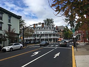
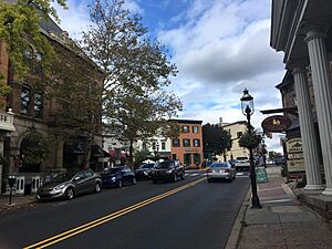
Main Street in Doylestown in October 2017
|
|||
|
|||
| Etymology: William Doyle | |||
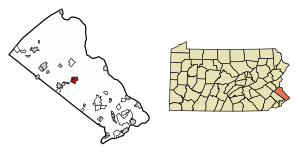
Location of Doylestown in Bucks County, Pennsylvania
|
|||
| Country | United States | ||
| State | Pennsylvania | ||
| County | Bucks | ||
| Founded | 1745 | ||
| Incorporated as a borough | 1838 | ||
| Government | |||
| • Type | Council-manager | ||
| Area | |||
| • Total | 2.16 sq mi (5.59 km2) | ||
| • Land | 2.16 sq mi (5.59 km2) | ||
| • Water | 0.00 sq mi (0.00 km2) | ||
| Elevation | 456 ft (139 m) | ||
| Population
(2020)
|
|||
| • Total | 8,300 | ||
| • Density | 3,847.94/sq mi (1,485.56/km2) | ||
| Time zone | UTC−5 (Eastern (EST)) | ||
| • Summer (DST) | UTC−4 (EDT) | ||
| ZIP Codes |
18901–18902
|
||
| Area codes | 215, 267, and 445 | ||
| FIPS code | 42-19784 | ||
Doylestown is a small town, called a borough, in Bucks County, Pennsylvania. It's the main town, or county seat, of Bucks County. In 2020, about 8,300 people lived here.
Doylestown is located about 20 miles (32 km) northwest of Trenton, New Jersey. It's also about 25 miles (40 km) north of Philadelphia. The town is part of the larger Philadelphia metropolitan area.
Contents
History of Doylestown
Before Europeans arrived, the Lenape Indian tribe lived in the area that is now Doylestown.
How Doylestown Started
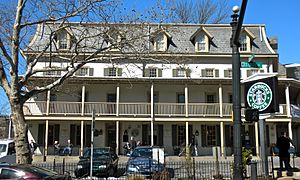
In 1745, an Irish settler named William Doyle opened a tavern. This tavern was located at an important crossroads. These roads connected major cities like Philadelphia and Easton. The tavern's good location helped Doylestown grow. Another inn, called Sign of the Ship, opened in 1774.
Growing into a Town
In 1802, Doylestown got its first post office. Letters were delivered by the postmaster, Charles Stewart, who carried them in his tall hat!
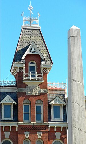
Over time, more people moved to Central and Upper Bucks County. They wanted the county's main offices to be in Doylestown instead of Newtown. So, in 1810, the state government agreed to move the county seat to Doylestown. The first court session was held here in 1813. This led to more buildings being built, like offices for lawyers.
To keep the town safe, Doylestown started its first fire company in 1825. In 1838, Doylestown officially became a borough. This meant it could govern itself more independently.
Modern Changes
In 1846, an electric telegraph station was built. This allowed faster communication. The railroad arrived in 1856, connecting Doylestown to other places. Gas lights were introduced in 1854, making the streets brighter at night.
Because Doylestown didn't have strong water power, it didn't become a big industrial town. Instead, it grew as a place for professionals and homes. After the American Civil War, more land was developed for houses.
In 1869, Doylestown got a water system. The first telephone line arrived in 1878. Trolley lines connected Doylestown to nearby towns starting in 1897.
Doylestown in the 1900s
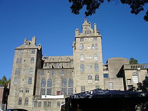
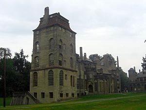
In the early 1900s, Doylestown became famous for its "Tools of the Nation-Maker" museum. Henry Chapman Mercer built this unique concrete building in 1916. It holds his collection of old tools. Mercer also left his home, Fonthill, and the Moravian Pottery and Tile Works to be museums.
By the 1930s, cars became popular, and the trolley lines closed. The Great Depression caused some older houses to fall apart. But after World War II, Doylestown's businesses grew. Streets were paved, and new homes were built. The town's population grew a lot in the 1950s, 60s, and 70s.
In the 1960s, shopping malls started to hurt local businesses. People in Doylestown worked together to save their historic buildings. They improved the downtown area, making it a better place to shop and visit.
By the 1990s, Doylestown became a popular tourist spot. The Mercer Museum and other attractions brought many visitors. The County Theater, an old movie theater, was restored. A new library and art museum were also built. Doylestown became known for its lively restaurants and nightlife.
The Doylestown Historic District and several other important buildings are listed on the National Register of Historic Places. This means they are protected for their historical value.
Geography and Climate
Doylestown Borough covers about 2.2 square miles (5.7 square kilometers) of land. It is mostly surrounded by Doylestown Township. Small streams like Cooks Run and Neshaminy Creek flow through the area.
Weather in Doylestown
Doylestown has a climate with hot summers and cold winters. Summers are usually warm and humid. The hottest temperature ever recorded was 102.8°F (39.3°C) in July 2011. Winters are cold, and the average snowfall is about 30-36 inches (76-91 cm) per year. The coldest temperature ever recorded was -12.1°F (-24.5°C) in January 1984. Sometimes, there are big snowstorms or ice storms.
| Climate data for Doylestown, Elevation 387 ft (118 m), 1981–2010 normals, extremes 1981–2018 | |||||||||||||
|---|---|---|---|---|---|---|---|---|---|---|---|---|---|
| Month | Jan | Feb | Mar | Apr | May | Jun | Jul | Aug | Sep | Oct | Nov | Dec | Year |
| Record high °F (°C) | 70.7 (21.5) |
77.6 (25.3) |
86.9 (30.5) |
93.8 (34.3) |
94.5 (34.7) |
95.6 (35.3) |
102.8 (39.3) |
99.2 (37.3) |
97.2 (36.2) |
89.2 (31.8) |
80.7 (27.1) |
75.0 (23.9) |
102.8 (39.3) |
| Mean daily maximum °F (°C) | 38.6 (3.7) |
41.9 (5.5) |
50.3 (10.2) |
62.1 (16.7) |
72.1 (22.3) |
80.9 (27.2) |
85.0 (29.4) |
83.3 (28.5) |
76.5 (24.7) |
65.1 (18.4) |
54.2 (12.3) |
42.8 (6.0) |
62.8 (17.1) |
| Daily mean °F (°C) | 29.9 (−1.2) |
32.7 (0.4) |
40.3 (4.6) |
51.0 (10.6) |
60.7 (15.9) |
70.0 (21.1) |
74.5 (23.6) |
72.9 (22.7) |
65.6 (18.7) |
53.9 (12.2) |
44.3 (6.8) |
34.4 (1.3) |
52.6 (11.4) |
| Mean daily minimum °F (°C) | 21.3 (−5.9) |
23.5 (−4.7) |
30.4 (−0.9) |
40.0 (4.4) |
49.4 (9.7) |
59.1 (15.1) |
64.0 (17.8) |
62.5 (16.9) |
54.8 (12.7) |
42.7 (5.9) |
34.3 (1.3) |
25.9 (−3.4) |
42.4 (5.8) |
| Record low °F (°C) | −12.1 (−24.5) |
−4.4 (−20.2) |
2.3 (−16.5) |
16.6 (−8.6) |
33.2 (0.7) |
40.6 (4.8) |
47.1 (8.4) |
41.8 (5.4) |
34.6 (1.4) |
23.3 (−4.8) |
11.0 (−11.7) |
−2.7 (−19.3) |
−12.1 (−24.5) |
| Average precipitation inches (mm) | 3.23 (82) |
2.62 (67) |
3.71 (94) |
3.90 (99) |
4.36 (111) |
4.33 (110) |
5.02 (128) |
4.05 (103) |
4.46 (113) |
4.24 (108) |
3.63 (92) |
3.90 (99) |
47.45 (1,205) |
| Average relative humidity (%) | 67.4 | 64.1 | 59.7 | 58.8 | 63.2 | 68.4 | 67.9 | 70.6 | 72.2 | 70.7 | 69.4 | 69.1 | 66.8 |
| Average dew point °F (°C) | 20.4 (−6.4) |
21.9 (−5.6) |
27.4 (−2.6) |
37.1 (2.8) |
48.1 (8.9) |
59.1 (15.1) |
63.2 (17.3) |
62.8 (17.1) |
56.4 (13.6) |
44.6 (7.0) |
34.9 (1.6) |
25.3 (−3.7) |
41.9 (5.5) |
| Source: PRISM | |||||||||||||
People of Doylestown
| Historical population | |||
|---|---|---|---|
| Census | Pop. | %± | |
| 1840 | 627 | — | |
| 1850 | 1,006 | 60.4% | |
| 1860 | 1,432 | 42.3% | |
| 1870 | 1,601 | 11.8% | |
| 1880 | 2,070 | 29.3% | |
| 1890 | 1,733 | −16.3% | |
| 1900 | 1,764 | 1.8% | |
| 1910 | 1,854 | 5.1% | |
| 1920 | 1,369 | −26.2% | |
| 1930 | 1,371 | 0.1% | |
| 1940 | 4,976 | 262.9% | |
| 1950 | 5,262 | 5.7% | |
| 1960 | 5,917 | 12.4% | |
| 1970 | 8,270 | 39.8% | |
| 1980 | 8,717 | 5.4% | |
| 1990 | 8,575 | −1.6% | |
| 2000 | 8,227 | −4.1% | |
| 2010 | 8,380 | 1.9% | |
| 2020 | 8,300 | −1.0% | |
| Sources: | |||
In 2020, Doylestown had a population of 8,300 people. Most residents (94.8%) were White. About 2.3% were Black or African American, and 1.9% were Asian. About 2.8% of the population had Hispanic or Latino family backgrounds.
In 2000, there were about 3,952 households in Doylestown. The average household had about 2 people. The median age of people in the borough was 44 years old.
Arts and Culture
Doylestown is famous for three special buildings designed by Henry Chapman Mercer.
- The Mercer Museum is a concrete castle-like building. It holds Mercer's huge collection of old American tools and everyday items.
- Fonthill (also called "Mercer's Castle") was Mercer's home. It's filled with his collections from all over the world.
- The Moravian Pottery and Tile Works is a working factory. Here, people still make tiles using old methods from the 1700s and 1800s.
The old prison building in Doylestown is now the James A. Michener Art Museum. It shows off beautiful artwork. The town also has a music school and groups for writers and artists.
Near Doylestown, there's a special Roman Catholic church called the National Shrine of Our Lady of Czestochowa. It has a famous painting called the Black Madonna.
Fun Places to Visit
- Delaware Valley University
- Fonthill Museum
- James A. Michener Art Museum
- Mercer Museum
- Moravian Pottery and Tile Works
- National Shrine of Our Lady of Czestochowa
- Oscar Hammerstein II Farm
- Peace Valley Park
- Pearl S. Buck House
- Ringing Rocks Park
Education
Doylestown is home to several schools in the Central Bucks School District.
- Elementary Schools: Doyle Elementary, Cold Spring Elementary, and Linden Elementary.
- Middle School: Lenape Middle School.
- High School: Central Bucks West, known for its strong girls' soccer team.
The Delaware Valley University campus is also nearby. This university is well-known for its programs in agriculture and science.
Media
The local daily newspaper, The Intelligencer, has its main office in Doylestown. There's also a radio station, WISP, which plays Catholic programming.
Getting Around Doylestown
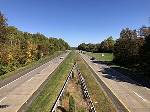
Doylestown has many public roads. Main Street is the main north-south road, and State Street is the main east-west road. Major highways like Pennsylvania Route 611 and U.S. Route 202 go around the center of town.
You can park on the street or in parking lots downtown. Some spots have parking meters during the day. There's also a free parking garage.
Public Transportation
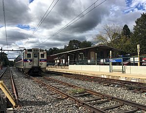
- Trains: The Lansdale/Doylestown Line of SEPTA Regional Rail connects Doylestown to Philadelphia. The Doylestown station is the last stop on this line.
- Buses: SEPTA City Bus Route 55 travels south from Doylestown towards Philadelphia.
- Intercity Buses: Companies like Trans-Bridge Lines and Greyhound Lines offer bus service from Doylestown to other cities like New York City and Scranton.
- Local Buses: The "Doylestown DART" is a small local bus system. It helps people, especially older residents, get to places like schools, stores, and the hospital.
Airports
The Doylestown Airport is a small airport for private planes. For commercial flights, the closest airports are in Trenton, New Jersey, and Allentown, Pennsylvania. Larger airports like Philadelphia International Airport and Newark Liberty International Airport are a bit further away.
Biking and Walking
Doylestown has a great system of trails and paths for biking and walking. It's called the Doylestown Community Bike & Hike System. It has over 25 miles (40 km) of paths. These paths connect the borough to Doylestown Township and other areas.
Utilities
Electricity and natural gas in Doylestown are provided by PECO Energy Company. The Doylestown Borough Water Department provides water. Bucks County Water and Sewer handles the sewer system. Trash and recycling are collected by the borough's Public Works department.
Famous People from Doylestown
Many interesting people have lived in or are from Doylestown:
- Kristen Alderson and Eddie Alderson, actors
- Jay Ansill, musician and author
- Stan and Jan Berenstain, authors of the Berenstain Bears books
- Pearl S. Buck, a writer who won the Nobel Prize
- Caroline Doty, a basketball player for UConn
- Molly Ephraim, actress
- Justin Guarini, American Idol runner-up
- Oscar Hammerstein II, famous musical lyricist
- Moss Hart, playwright and director
- Margaret Mead, a well-known anthropologist
- Henry Chapman Mercer, archaeologist and museum founder
- James A. Michener, famous author
- P!nk, singer
- Dodie Smith, author
- Stephen Sondheim, famous composer
- Timothy Stack, actor
See also
 In Spanish: Doylestown (Pensilvania) para niños
 | Roy Wilkins |
 | John Lewis |
 | Linda Carol Brown |


