Neshaminy Creek facts for kids
Quick facts for kids Neshaminy Creek |
|
|---|---|

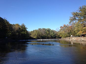
Neshaminy Creek in Tyler State Park
|
|
| Native name | Nishamening "at the place we drink twice" |
| Country | United States |
| State | Pennsylvania |
| County | Bucks |
| Township | New Britain Doylestown Warwick Buckingham Wrightstown Northampton Newtown Middletown Lower Southampton Bensalem Bristol |
| Borough | Chalfont New Britain Langhorne Hulmeville |
| Physical characteristics | |
| Main source | 220 feet (67 m) 40°16′59″N 75°12′19″W / 40.28306°N 75.20528°W |
| River mouth | 0 feet (0 m) 40°4′26″N 74°54′32″W / 40.07389°N 74.90889°W |
| Length | 40.7 miles (65.5 km) |
| Basin features | |
| Progression | Neshaminy Creek → Delaware River → Delaware Bay |
| River system | Delaware River |
| Basin size | 232 square miles (600 km2) |
| Landmarks | Wilma Quinlin Nature Preserve Twin Streams Park Lenape Bike and Hiking Path Castle Valley Park Central Park-Kids Castle Bridge Point Park Dark Hollow Diamond Ridge Day Camp Middle Bucks Institute of Technology Tyler State Park Bucks County Community College George School Core Creek Park Playwicki Park Playwicki Farm Park Idlewood Neshaminy State Park |
| Tributaries | |
| Slope | 5.7 feet per mile (1.08 m/km) |
The Neshaminy Creek is a stream that flows entirely through Bucks County, Pennsylvania. It is about 40.7 miles (65.5 kilometers) long. The creek starts south of the town of Chalfont, where its north and west branches meet. From there, it flows southeast towards Bristol Township and Bensalem Township. Finally, it joins the Delaware River.
The name "Neshaminy" comes from the Lenape people. It is believed to mean "place where we drink twice." This special name refers to a part of the creek called the Neshaminy Palisades. Here, the water slows down and makes a sharp turn, almost flowing back on itself. These tall, cliff-like areas are found in Dark Hollow Park.
Contents
About the Creek

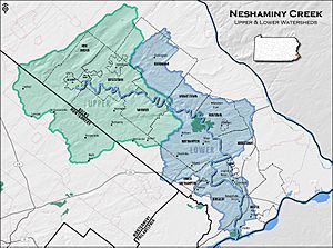
The area of land that drains into Neshaminy Creek is called its watershed. This watershed covers about 236 square miles (611 square kilometers). Most of this area (86 percent) is in Bucks County, and a smaller part (14 percent) is in Montgomery County. The Neshaminy Creek watershed is part of the larger Delaware River watershed.
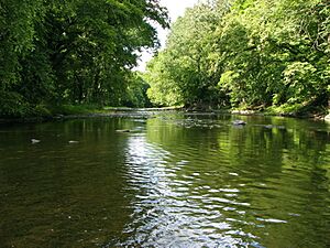
The creek flows mostly through suburban areas located north of Philadelphia. However, some parts of the creek still run through rural and forested areas. The Neshaminy Creek also flows through two state parks: Tyler State Park and Neshaminy State Park. Interestingly, the creek has three different smaller streams that flow into it, all named Mill Creek!
History of Neshaminy Creek
The name "Neshaminy" comes from the Lenape language, meaning "the place where we drink twice" or "two drinking places." This might refer to two springs that were once near a Lenape village. Native people often preferred to drink from springs rather than streams.
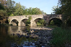
The Neshaminy was one of the first streams in Bucks County to have ferries and bridges built across it. In 1832, a book called the Gordon Gazetteer even called it the Neshaminy River. It mentioned that there were many bridges, including a special drawbridge near its mouth. This drawbridge allowed boats to pass through.
The creek has experienced several big floods over the years. In 1833, a flood known as the Mina flood washed away most of the bridges. Then, in 1865, an even bigger flood happened. This flood was 6 feet (1.8 meters) higher than the 1833 flood! It destroyed almost all the bridges downstream and caused a lot of damage. When the floodwaters reached the Delaware River, they were so strong that they carried a huge pile of debris all the way to the New Jersey shoreline. This even stopped ships from moving on the river.
Flooding and Safety
Like many other rivers and streams, the Neshaminy Creek can cause flooding in nearby areas, especially after heavy rains. The water level can rise more than 10 feet (3 meters) above its normal level during severe storms.
For example, during Hurricane Floyd in 1999, the creek flooded significantly. In 2005, money was set aside to help prevent future floods along the Neshaminy Creek. More major flooding occurred in 2006.
In 2011, Hurricane Irene and Tropical Storm Lee (2011) caused the Neshaminy Creek to reach levels not seen in 100 years. Repairs from these storms cost around $1 million.
Creek Crossings and Bridges

Many roads and railways cross over the Neshaminy Creek. Bridges are important for people and vehicles to get from one side to the other. Here is a list of some of the crossings over the Neshaminy Creek:
| Crossing | NBI Number | Length | Lanes | Spans | Material/Design | Built | Reconstructed | Coordinates |
|---|---|---|---|---|---|---|---|---|
| Bristol Road | 7218 | 47 metres (154 ft) | 2 | 3 | Prestressed Concrete Box Beam or Girders-single or spread | 1967 | 40°17′5″N 75°11′17.5″W / 40.28472°N 75.188194°W | |
| Upper State Road | 7537 | 71 metres (233 ft) | 2 | 3 | Prestressed concrete Stringer/Multi-beam or Girder | 1973 | 40°17′21″N 75°10′43.3″W / 40.28917°N 75.178694°W | |
| U.S. Route 202 | 47700 | 160 metres (520 ft) | 2 | 4 | continuous Prestressed concrete Stringer/Multi-beam or Girder | 2012 | 40°16′54″N 75°10′30″W / 40.28167°N 75.17500°W | |
| Lower State Road | 46491 | 65 metres (213 ft) | 2 | 3 | continuous Prestressed concrete Box Beam or Girders - single or spread | 2012 | 40°17′10.3″N 75°9′38.55″W / 40.286194°N 75.1607083°W | |
| Pennsylvania Route 611 (South Easton Road) | 7062 | 82 metres (269 ft) | 2 | 2 | Steel continuous Stringer/Multi-beam or Girder | 1963 | 1999 | 40°16′36.7″N 75°7′39.22″W / 40.276861°N 75.1275611°W |
| Pennsylvania Route 263 (York Road) | 6961 | 77 metres (253 ft) | 2 | 3 | continuous steel Stringer/Multi-beam or Girder | 1969 | 2017 | 40°16′32.5″N 75°5′1.9″W / 40.275694°N 75.083861°W |
| Old York Road | - | - | - | - | - | - | - | 40°16′34″N 75°4′59″W / 40.27611°N 75.08306°W |
| Mill Road | 7529 | 88 metres (289 ft) | 1 | 2 | Steel Thru Truss | 40°16′9.8″N 75°4′26.8″W / 40.269389°N 75.074111°W | ||
| Dark Hollow Road | - | - | - | - | - | - | - | 40°15′26″N 75°3′26″W / 40.25722°N 75.05722°W |
| Rushland-Jamison Road | 7328 | 69 metres (226 ft) | 2 | 5 | Concrete Tee Beam | 1947 | 2013 | 40°15′37.8″N 75°2′7″W / 40.260500°N 75.03528°W |
| New Hope Railroad | - | - | - | - | - | - | - | 40°15′18″N 75°1′56″W / 40.25500°N 75.03222°W |
| Pennsylvania Route 232 (Second Street Pike) | 6956 | 79 metres (259 ft) | 2 | 3 | Prestressed concrete Stringer/Multi-beam or girder | 1982 | 40°15′3.7″N 75°0′31.7″W / 40.251028°N 75.008806°W | |
| Worthington Mill Road | 7330 | 75 metres (246 ft) | 2 | 2 | continuous Steel Stringer/Multi-beam or Girder | 1954 | 40°14′52″N 74°59′43.3″W / 40.24778°N 74.995361°W | |
| Schofield Ford Covered Bridge | - | - | - | - | - | - | - | 40°14′39″N 74°58′50″W / 40.24417°N 74.98056°W |
| Tyler State Park Main Park Road | - | - | - | - | - | - | - | 40°13′54″N 74°58′26″W / 40.23167°N 74.97389°W |
| Pennsylvania Route 332 (Newtown Richboro Road) | 44293 | 88 metres (289 ft) | 2 | 3 | continuous Prestressed concrete Stringer/Multi-beam or Girder | 2007 | 40°13′26.1″N 74°57′55.2″W / 40.223917°N 74.965333°W | |
| Pennsylvania Route 532 (Buck Road) | 7049 | 63 metres (207 ft) | 2 | 3 | Concrete Arch-deck | 1932 | 40°12′41.1″N 74°56′52.59″W / 40.211417°N 74.9479417°W | |
| Bridgetown Pike | 41028 | 90 metres (300 ft) | 2 | 2 | continuous Steel Stringer or Multi-beam or Girder | 2001 | 40°11′21.47″N 74°55′40.6″W / 40.1892972°N 74.927944°W | |
| Abandoned railroad | - | - | - | - | - | - | - | 40°10′34″N 74°57′23″W / 40.17611°N 74.95639°W |
| Norfolk Southern Railway's Morrisville Line | - | - | - | - | - | - | - | 40°10′29″N 74°57′25″W / 40.17472°N 74.95694°W |
| Pennsylvania Route 213 (West Maple Avenue) | - | - | - | - | - | - | - | 40°10′27″N 74°57′26″W / 40.17417°N 74.95722°W |
| Brownsville Road | 7278 | 77 metres (253 ft) | 2 | 4 | Prestressed Concrete Box Beam or Girders-Multiple | 1956 | 1990 | 40°10′4.1″N 74°57′5.33″W / 40.167806°N 74.9514806°W |
| SEPTA's West Trenton Line/CSX Transportation's Trenton Subdivision | - | - | - | - | - | - | - | 40°8′53″N 74°57′26″W / 40.14806°N 74.95722°W |
| Old Lincoln Highway | 7257 | 98.8 metres (324 ft) | 2 | 5 | Concrete Arch-Deck | 1921 | 40°8′44″N 74°57′25″W / 40.14556°N 74.95694°W | |
| U.S. Route 1 (Lincoln Highway) | 6719 | 97 metres (318 ft) | 2 | 3 | Concrete Arch-Deck | 1933 | 1965 | 40°8′42.6″N 74°57′15.52″W / 40.145167°N 74.9543111°W |
| Pennsylvania Route 513 (Hulmeville Road) | 7041 | 89 metres (292 ft) | 3 | 3 | Prestressed concrete continuous Box Beam or Girders-single or spread | 1989 | 40°8′28″N 74°54′45.84″W / 40.14111°N 74.9127333°W | |
| Interstate 276 (Pennsylvania Turnpike) | - | - | - | - | - | - | - | 40°7′44″N 74°54′0″W / 40.12889°N 74.90000°W |
| New Falls Road | - | - | - | - | - | - | - | 40°7′25″N 74°54′5″W / 40.12361°N 74.90139°W |
| Interstate 95 (Delaware Expressway) southbound | 6854 | 181.4 metres (595 ft) | 2 | 7 | Prestressed concrete multi-beam or Girder | 1964 | 2010 | 40°6′15″N 74°54′9″W / 40.10417°N 74.90250°W |
| Interstate 95 (Delaware Expressway) northbound | 6851 | 181.4 metres (595 ft) | 2 | 7 | Prestressed concrete multi-beam or Girder | 1964 | 2010 | 40°6′16″N 74°54′9″W / 40.10444°N 74.90250°W |
| U.S. Route 13 (Bristol Pike) | - | - | - | - | - | - | - | 40°5′36″N 74°54′48″W / 40.09333°N 74.91333°W |
| Amtrak's Northeast Corridor/SEPTA's Trenton Line | - | - | - | - | - | - | - | 40°5′33″N 74°54′49″W / 40.09250°N 74.91361°W |
| State Road | - | - | - | - | - | - | - | 40°5′5″N 74°54′39″W / 40.08472°N 74.91083°W |
Tributaries of Neshaminy Creek
Many smaller streams flow into the Neshaminy Creek. These are called tributaries. Here are some of the named tributaries:
- Mill Creek
- Newtown Creek
- Mill Creek
- Little Neshaminy Creek
- Cooks Run
- Mill Creek
- North Branch Neshaminy Creek
- West Branch Neshaminy Creek
Towns and Townships Along the Creek
The Neshaminy Creek flows through or near many towns and townships in Bucks County and Montgomery County. Here are some of them:
- Bensalem Township
- Bristol Township
- Buckingham Township
- Chalfont
- Doylestown
- Doylestown Township
- Hatfield
- Hulmeville
- Ivyland
- Langhorne
- Langhorne Manor
- Lansdale
- Lower Southampton Township
- Middletown Township
- New Britain
- New Britain Township
- Newtown
- Newtown Township
- Northampton Township
- Penndel
- Plumstead Township
- Upper Southampton Township
- Warminster Township
- Warwick Township
- Wrightstown Township
 | William Lucy |
 | Charles Hayes |
 | Cleveland Robinson |


