
Hulmeville, Pennsylvania facts for kids
Quick facts for kids
Hulmeville, Pennsylvania
|
||
|---|---|---|

Borough hall in Hulmeville
|
||
|
||

Location in Bucks County, Pennsylvania
|
||

Hulmeville, Pennsylvania
Location in Pennsylvania

Hulmeville, Pennsylvania
Location in the United States
|
||
| Country | United States | |
| State | Pennsylvania | |
| County | Bucks | |
| Area | ||
| • Total | 0.37 sq mi (0.97 km2) | |
| • Land | 0.36 sq mi (0.92 km2) | |
| • Water | 0.02 sq mi (0.04 km2) | |
| Elevation | 46 ft (14 m) | |
| Population
(2020)
|
||
| • Total | 982 | |
| • Density | 2,758.43/sq mi (1,065.09/km2) | |
| Time zone | UTC-5 (Eastern (EST)) | |
| • Summer (DST) | UTC-4 (EDT) | |
| ZIP Code |
19047
|
|
| Area codes | 215, 267 and 445 | |
| FIPS code | 42-36192 | |

Hulmeville is a small town, called a borough, located in Bucks County, Pennsylvania, in the United States. In 2020, about 982 people lived there.
Contents
History of Hulmeville
How Hulmeville Got Its Name
The Hulme family, originally from a place called DeHoulme, came from Normandy. They settled in England before some family members moved to America around 1700. George Hulme Sr. and George Hulme Jr. bought land in Bucks County.
Later, John Hulme Jr. bought land along the Neshaminy Creek in 1796. He named this area Milford. Soon, the village grew with homes, mills, and shops. John Jr.'s five sons became a miller, storekeepers, a tanner, and a farmer.
A New Name for the Village
John Hulme Jr. helped start a post office in Milford in 1809. His son, Isaac, was the first postmaster. After this, the village name was changed to Hulmeville. People say the state government changed the name to honor John Jr.
The First Bank
In 1814, the very first bank in Bucks County was started in Hulmeville. John Jr. was its first president. This bank later moved to Bristol in 1830 and changed its name to Farmers' National Bank.
Hulmeville's Historic District
The Hulmeville Historic District is a special area in town. It was added to the National Register of Historic Places in 1986. This means it's recognized for its important history and old buildings.
Geography
Hulmeville is located at 40°8′36″N 74°54′26″W / 40.14333°N 74.90722°W. It covers about 0.4 square miles (about 1 square kilometer) of land.
The Neshaminy Creek flows right through Hulmeville.
Population and People
|
||||||||||||||||||||||||||||||||||||||||||||||||||||||||||||||||||||||||
In 2010, the population of Hulmeville was 1,003 people. By 2020, it was 982 people.
Education
Students in Hulmeville attend schools in the Neshaminy School District.
- Younger students (grades K-4) go to Herbert Hoover Elementary School.
- Middle school students (grades 5-8) attend Maple Point Middle School.
- High school students (grades 9-12) go to Neshaminy High School.
Transportation
Hulmeville has about 4.20 miles (6.76 km) of public roads. Some are kept up by the state, and others by the borough itself.
Pennsylvania Route 513 is the main highway that goes through Hulmeville. It runs north and south through the western part of the borough.
You can also get around Hulmeville using public transportation. SEPTA provides bus service with Route 130. This bus connects Hulmeville to Northeast Philadelphia and Bucks County Community College in Newtown.
Climate
Weather in Hulmeville
Hulmeville has a Humid subtropical climate (Cfa). This means it has hot, humid summers and cool to cold winters.
- Summers are usually warm and a bit humid. Sometimes it can get very hot.
- The hottest temperature ever recorded was 102.9°F (39.4°C) on July 22, 2011.
- Winters can be cold. The coldest temperature ever recorded was -9.4°F (-23.0°C) on January 22, 1984.
- The area gets snow, usually between 24 and 30 inches (61-76 cm) each winter. Big snowstorms happen every few years.
- July is usually the wettest month, with lots of thunderstorms.
| Climate data for Hulmeville, Elevation 59 ft (18 m), 1981-2010 normals, extremes 1981-2018 | |||||||||||||
|---|---|---|---|---|---|---|---|---|---|---|---|---|---|
| Month | Jan | Feb | Mar | Apr | May | Jun | Jul | Aug | Sep | Oct | Nov | Dec | Year |
| Record high °F (°C) | 71.7 (22.1) |
78.0 (25.6) |
87.6 (30.9) |
94.8 (34.9) |
95.8 (35.4) |
96.9 (36.1) |
102.9 (39.4) |
100.8 (38.2) |
98.7 (37.1) |
88.7 (31.5) |
81.5 (27.5) |
76.2 (24.6) |
102.9 (39.4) |
| Mean daily maximum °F (°C) | 40.5 (4.7) |
43.7 (6.5) |
51.9 (11.1) |
63.8 (17.7) |
73.3 (22.9) |
82.5 (28.1) |
86.6 (30.3) |
85.0 (29.4) |
78.2 (25.7) |
66.9 (19.4) |
56.0 (13.3) |
44.9 (7.2) |
64.5 (18.1) |
| Daily mean °F (°C) | 32.3 (0.2) |
34.8 (1.6) |
42.1 (5.6) |
52.8 (11.6) |
62.1 (16.7) |
71.7 (22.1) |
76.3 (24.6) |
74.8 (23.8) |
67.7 (19.8) |
56.1 (13.4) |
46.5 (8.1) |
36.7 (2.6) |
54.6 (12.6) |
| Mean daily minimum °F (°C) | 24.0 (−4.4) |
25.9 (−3.4) |
32.4 (0.2) |
41.8 (5.4) |
50.9 (10.5) |
60.8 (16.0) |
65.9 (18.8) |
64.5 (18.1) |
57.1 (13.9) |
45.4 (7.4) |
37.0 (2.8) |
28.5 (−1.9) |
44.6 (7.0) |
| Record low °F (°C) | −9.4 (−23.0) |
−2.3 (−19.1) |
4.4 (−15.3) |
18.0 (−7.8) |
33.4 (0.8) |
42.4 (5.8) |
48.5 (9.2) |
43.3 (6.3) |
36.7 (2.6) |
25.6 (−3.6) |
12.7 (−10.7) |
0.3 (−17.6) |
−9.4 (−23.0) |
| Average precipitation inches (mm) | 3.56 (90) |
2.73 (69) |
4.23 (107) |
3.89 (99) |
4.26 (108) |
4.25 (108) |
5.07 (129) |
4.33 (110) |
4.19 (106) |
3.74 (95) |
3.49 (89) |
3.97 (101) |
47.71 (1,212) |
| Average relative humidity (%) | 65.4 | 62.0 | 57.8 | 57.3 | 61.9 | 65.4 | 66.0 | 68.2 | 69.1 | 68.6 | 66.9 | 67.1 | 64.7 |
| Average dew point °F (°C) | 22.0 (−5.6) |
23.1 (−4.9) |
28.3 (−2.1) |
38.1 (3.4) |
48.9 (9.4) |
59.5 (15.3) |
64.1 (17.8) |
63.6 (17.6) |
57.2 (14.0) |
45.9 (7.7) |
36.1 (2.3) |
26.8 (−2.9) |
42.9 (6.1) |
| Source: PRISM | |||||||||||||
Ecology
Plants and Nature in Hulmeville
The natural plant life in Hulmeville would mostly be Oak trees. This area is part of the Eastern Hardwood Forest.
The climate here means that spring flowers usually start blooming around April 7. The beautiful fall colors, when leaves change, usually look their best around November 4.
Images for kids
-
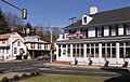
Downtown Hulmeville
-
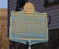
Historical marker in Hulmeville
-
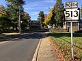
PA 513 northbound in Hulmeville


_just_north_of_Trenton_Avenue_in_Hulmeville,_Bucks_County,_Pennsylvania.jpg)
See also
 In Spanish: Hulmeville para niños
