
Chalfont, Pennsylvania facts for kids
Quick facts for kids
Chalfont
|
|||
|---|---|---|---|
|
Home rule municipality
|
|||

Main Street in Chalfont
|
|||
|
|||

Location of Chalfont in Bucks County, Pennsylvania.
|
|||

Chalfont
Location in Pennsylvania

Chalfont
Location in the United States
|
|||
| Country | United States | ||
| State | Pennsylvania | ||
| County | Bucks | ||
| Purchased | 1683 | ||
| Area | |||
| • Total | 1.64 sq mi (4.24 km2) | ||
| • Land | 1.62 sq mi (4.19 km2) | ||
| • Water | 0.02 sq mi (0.05 km2) | ||
| Elevation | 272 ft (83 m) | ||
| Population
(2020)
|
|||
| • Total | 4,253 | ||
| • Density | 2,628.55/sq mi (1,014.63/km2) | ||
| Time zone | UTC-5 (Eastern (EST)) | ||
| • Summer (DST) | UTC-4 (EDT) | ||
| ZIP Code |
18914
|
||
| Area code(s) | 215, 267 and 445 | ||
| FIPS code | 42-12504 | ||


Chalfont is a small town, called a borough, located in Bucks County, Pennsylvania, United States. It has a special "home rule" status, which means it can make some of its own local laws. In 2020, about 4,253 people lived here.
Chalfont is named after a place in England called Chalfont St Giles. This English town was once home to William Penn's first wife. William Penn was a very important person who founded the state of Pennsylvania.
Contents
Discovering Chalfont's Past
How Chalfont Began
Long ago, the Lenape Native Americans lived in the area that is now Chalfont. In 1683, William Penn made an agreement with the local chief. He then divided the land for a group called the Free Society of Traders.
Around 1720, a man named Simon Butler bought over 150 acres of land, which included the "Village of Chalfont." He built his home and a mill, and later bought even more land. Simon Butler was a key figure who helped the area grow.
Chalfont's Changing Names
After Simon Butler passed away, his land was divided among many people. Over the years, before 1901, Chalfont was known by several different names. These included Butler's Mill, Kungle's Tavern, Barndtsville, and Whitehallville.
For a long time, the most important building in the area was a tavern, which is like an old-fashioned inn or pub. This building burned down many times but was always rebuilt. Today, a pizza place stands where the tavern used to be.
The Arrival of the Train Station
During the Victorian era, a train station was built in Chalfont. This was a big deal! The train made it much easier for people to travel and for goods to be moved. It helped the community grow a lot and led to the building of many beautiful Victorian-style houses that you can still see today.
Forest Park: A Place for Fun
In 1885, a special place called Forest Park was created in Chalfont. It started as a simple picnic area where people could enjoy music. The new train station helped the park become very popular.
As the years went by, Forest Park grew into a small amusement park. Local families could enjoy rides and a large swimming pool, which was built in the 1930s. The park also hosted music events and many company picnics. Sadly, Forest Park closed its doors for good in 1968.
Washington's Army Passes Through
An interesting historical fact is that in 1778, parts of George Washington's army marched through the Chalfont area. They were traveling from their camp at Valley Forge towards the Battle of Monmouth.
Chalfont's Location and Nature
Where is Chalfont?
Chalfont is a small area, covering about 1.6 square miles (4.2 square kilometers). Most of this area is land. The Neshaminy Creek and Pine Run are two streams that flow through Chalfont. The borough is part of the larger Delaware Valley region.
Understanding Chalfont's Climate
Chalfont has a climate with hot summers. This means it has warm, humid summers and cold winters.
- Summer Heat: While most summer days are a bit humid, sometimes it can get very hot and sticky. The highest temperature recorded since 1981 was 102.7°F (39.3°C) on July 22, 2011.
- Winter Cold: In winter, it can get very cold. The coldest temperature recorded since 1981 was -11.9°F (-24.4°C) on January 22, 1984. Sometimes, strong winds make it feel even colder.
- Rain and Snow: July is usually the wettest month, with lots of thunderstorms. Chalfont gets about 30 to 36 inches (76 to 91 cm) of snow each winter. Big snowstorms with more than 12 inches (30 cm) of snow happen every few years.
| Climate data for Chalfont. Elevation: 279 feet (85 m). 1981-2010 Averages (1981-2018 Records). | |||||||||||||
|---|---|---|---|---|---|---|---|---|---|---|---|---|---|
| Month | Jan | Feb | Mar | Apr | May | Jun | Jul | Aug | Sep | Oct | Nov | Dec | Year |
| Record high °F (°C) | 71.0 (21.7) |
78.0 (25.6) |
87.0 (30.6) |
93.7 (34.3) |
94.8 (34.9) |
95.7 (35.4) |
102.7 (39.3) |
99.9 (37.7) |
97.6 (36.4) |
89.2 (31.8) |
80.8 (27.1) |
75.4 (24.1) |
102.7 (39.3) |
| Mean daily maximum °F (°C) | 39.1 (3.9) |
42.3 (5.7) |
50.7 (10.4) |
62.7 (17.1) |
72.7 (22.6) |
81.5 (27.5) |
85.6 (29.8) |
84.0 (28.9) |
77.0 (25.0) |
65.6 (18.7) |
54.6 (12.6) |
43.2 (6.2) |
63.3 (17.4) |
| Daily mean °F (°C) | 30.3 (−0.9) |
33.2 (0.7) |
40.8 (4.9) |
51.5 (10.8) |
61.2 (16.2) |
70.4 (21.3) |
74.9 (23.8) |
73.4 (23.0) |
66.0 (18.9) |
54.3 (12.4) |
44.6 (7.0) |
34.7 (1.5) |
53.0 (11.7) |
| Mean daily minimum °F (°C) | 21.6 (−5.8) |
24.0 (−4.4) |
30.8 (−0.7) |
40.3 (4.6) |
49.7 (9.8) |
59.4 (15.2) |
64.3 (17.9) |
62.8 (17.1) |
54.9 (12.7) |
42.9 (6.1) |
34.6 (1.4) |
26.2 (−3.2) |
42.7 (5.9) |
| Record low °F (°C) | −11.9 (−24.4) |
−4.3 (−20.2) |
2.6 (−16.3) |
16.5 (−8.6) |
32.8 (0.4) |
40.8 (4.9) |
47.4 (8.6) |
42.0 (5.6) |
34.6 (1.4) |
23.4 (−4.8) |
10.9 (−11.7) |
−2.8 (−19.3) |
−11.9 (−24.4) |
| Average precipitation inches (mm) | 3.29 (84) |
2.67 (68) |
3.77 (96) |
3.95 (100) |
4.32 (110) |
4.26 (108) |
4.94 (125) |
4.07 (103) |
4.46 (113) |
4.14 (105) |
3.63 (92) |
3.94 (100) |
47.44 (1,205) |
| Average relative humidity (%) | 66.8 | 63.4 | 59.1 | 58.2 | 62.5 | 67.4 | 67.7 | 69.9 | 71.4 | 70.2 | 69.1 | 69.1 | 66.3 |
| Average dew point °F (°C) | 20.6 (−6.3) |
22.1 (−5.5) |
27.6 (−2.4) |
37.3 (2.9) |
48.3 (9.1) |
59.1 (15.1) |
63.5 (17.5) |
63.0 (17.2) |
56.5 (13.6) |
44.8 (7.1) |
35.1 (1.7) |
25.6 (−3.6) |
42.1 (5.6) |
| Source: PRISM | |||||||||||||
Nature and Plants in Chalfont
The natural plants in Chalfont are mostly Oak trees and other Hardwood trees that grow in Eastern forests. Spring flowers usually start blooming around April 11, and the leaves change color in the fall, peaking around October 30.
Getting Around Chalfont
_just_south_of_Kerns_Avenue_in_Chalfont,_Bucks_County,_Pennsylvania.jpg)
Chalfont has about 19.70 miles (31.70 km) of public roads. Some are kept up by the state, and others by the borough itself.
Main Roads in Chalfont
Two important roads go through Chalfont:
- U.S. Route 202 Business: This road follows the older path of US 202 along Butler Avenue.
- Pennsylvania Route 152: This road runs through Limekiln Pike, Butler Avenue, and Main Street. For a short distance, it shares the road with US 202 Business.
Public Transportation Options
Chalfont has a train station called Chalfont station. It's part of SEPTA Regional Rail's Lansdale/Doylestown Line. This train can take you to Doylestown or to Center City Philadelphia.
There's also a bus service called Bucks County Transport's DART West bus. It runs on weekdays from Chalfont and connects to another bus that goes to Doylestown.
Who Lives in Chalfont?
| Historical population | |||
|---|---|---|---|
| Census | Pop. | %± | |
| 1880 | 216 | — | |
| 1910 | 303 | — | |
| 1920 | 317 | 4.6% | |
| 1930 | 550 | 73.5% | |
| 1940 | 670 | 21.8% | |
| 1950 | 828 | 23.6% | |
| 1960 | 1,410 | 70.3% | |
| 1970 | 2,366 | 67.8% | |
| 1980 | 2,802 | 18.4% | |
| 1990 | 3,069 | 9.5% | |
| 2000 | 3,900 | 27.1% | |
| 2010 | 4,009 | 2.8% | |
| 2020 | 4,253 | 6.1% | |
| Sources: | |||
In 2010, most people living in Chalfont were White (92.7%). There were also smaller groups of Black or African American (1.4%), Native American (0.3%), and Asian (3.0%) residents. About 1.7% of the population had Hispanic or Latino family backgrounds.
In 2000, there were about 3,977 people living in Chalfont.
- Families: About 40.1% of homes had children under 18. Most homes (66.2%) were married couples living together.
- Age Groups: The population was spread out by age. About 29.1% were under 18, and 8.6% were 65 or older. The average age was 36 years old.
- Income: The average income for a family in Chalfont was about $70,592 per year.
Arts and Historic Buildings
The Chalfont Historic District is a special area listed on the National Register of Historic Places. This means it's important for its history. You can find many beautiful American colonial and Victorian-style houses here.
Many of these old homes are now businesses. They are mostly found near the main intersection of Butler Avenue (U.S. Route 202 Business) and North Main Street (Pennsylvania Route 152).
Famous People from Chalfont
- Bobby Shantz: He was a famous baseball player who won the Most Valuable Player award in 1952. After his baseball career, he ran a popular bowling alley and diner in Chalfont with other baseball players. His awards, like his Gold Glove and MVP trophy, were displayed there.
Images for kids
-
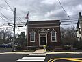
Chalfont Borough Hall

See also
 In Spanish: Chalfont para niños
