kids encyclopedia robot

Delaware Valley facts for kids

Kids Encyclopedia Facts
Quick facts for kids
Delaware Valley
Greater Philadelphia
Philadelphia metropolitan area

Philadelphia-Camden-Wilmington, PA-NJ-DE-MD CSA
Combined Statistical Area
Center City Philadelphia (in background) and the Schuylkill River (on left) as seen from South Street Bridge in July 2016
Country Flag of United States.svg United States
States Flag of Pennsylvania.svg Pennsylvania
Flag of New Jersey.svg New Jersey
Flag of Delaware.svg Delaware
Flag of Maryland.svg Maryland
Principal city Philadelphia
Satellite cities and towns Camden
Wilmington
Atlantic City
Reading
Trenton
Vineland
Conshohocken
Dover
Chester
Upper Darby
Media
Middletown Township
Hammonton
Pennsauken Township
Norristown
Doylestown
Cherry Hill
West Chester
Evesham
Washington Township
Millville
Salem
Cape May Court House
Lower Township
The Wildwoods
Brigantine
Ventnor City
Margate City
Ocean City
Sea Isle City
Haverford
Bridgeton
Coatesville
Lower Merion
Gloucester Township
Downingtown
Phoenixville
New Castle
Pottstown
King of Prussia
Bensalem Township
Burlington City and Burlington Township
Middle Township (Cape May County)
Mount Holly
Newark
Hamilton Township (Mays Landing)
Woodbury
Elkton
Cheltenham Township
Abington Township
Bristol Township
Mount Laurel
Northampton Township
Winslow Township
New Hope
Falls Township
Middletown Township (Bucks County)
Egg Harbor Township
Galloway Township
Pennsville
Maurice River Township
Area
 • Urban
1,981.4 sq mi (5,131.7 km2)
 • Metro
5,118 sq mi (13,256 km2)
Elevation
0 - 1,080 ft (0 - 329 m)
Population
 (2021 est.)
 • Urban
5,441,567 (5th)
 • Metro density 1,217.00/sq mi (469.89/km2)
 • MSA
6,228,601 (7th)
 • CSA
7,366,346 (9th)
  MSA/CSA = 2021, Urban = 2010
GDP
 • MSA $518.5 billion (2022)
Time zone UTC−5 (EST)
 • Summer (DST) UTC−4 (EST)
Area codes 215/267/445, 302, 410/443/667, 609/640, 610/484/835, 717/223, 856

The Delaware Valley, sometimes referred to as Greater Philadelphia or the Philadelphia metropolitan area, is a major metropolitan region in the Northeast United States that centers around Philadelphia, the nation's sixth-most populous city, and spans parts of four U.S. states: southeastern Pennsylvania, southern New Jersey, northern Delaware, and the northern Eastern Shore of Maryland. With a core metropolitan statistical area population of 6.288 million residents and a combined statistical area population of 7.366 million as of the 2020 census, the Delaware Valley is the eighth-largest metropolitan region in the United States and the 68th-largest metropolitan region in the world.

In addition to Philadelphia, other major population centers in the Delaware Valley include Reading, Upper Darby Township, and Chester in Pennsylvania; Atlantic City, Camden, Vineland, and Cherry Hill in South Jersey; and Wilmington and Dover in Delaware. As of 2022, the Philadelphia metropolitan area's gross domestic product (GDP) exceeds US$518 billion, making it the tenth-largest metropolitan economy in the nation.

The Delaware Valley has been influential in the nation's history and economy and home to many people and sites significant to American culture, history, and politics. Philadelphia is sometimes known as "The Birthplace of America", a reference to is role as the revolutionary capital during the colonial era, where the Second Continental Congress gathered at Independence Hall to unanimously adopt the Declaration of Independence, authorize the formation of the Continental Army, and appoint George Washington its commander to resist the British. Following the Continental Army's victory, Philadelphia served as the nation's first capital for most of the 18th century until 1800, when construction of Washington, D.C. was completed. In 1789, the U.S. Constitution, the world's longest-standing body of federal law, was ratified at Independence Hall in Philadelphia in 1789.

The Delaware Valley is one of the nation's leading regions for academia and academic research with a considerable number of globally-known and highly ranked universities, including the University of Pennsylvania, one of the nation's eight Ivy League universities. Other major universities and colleges in the region include Drexel University, Thomas Jefferson University, Rowan University, Villanova University, Saint Joseph's University, Temple University, Rutgers University–Camden, La Salle University, the University of Delaware, Stockton University, and others.

Philadelphia and the Delaware Valley are a biotechnology hub. As of 2024, metropolitan Philadelphia ranks as one of the Big Five U.S. venture capital hubs, facilitated by its proximity to both New York City's entrepreneurial and financial ecosystems and to the federal regulatory environment of Washington, D.C. Elsewhere in the Delaware Valley, South Jersey has emerged as an East Coast epicenter for logistics and major warehouses.

Culturally, the region is home to the dialect or accent known as Philadelphia English, shares a unique cuisine known as Philadelphia cuisine, has played a formidable role in popular music, and is known for having one of the nation's most passionate and devoted sports cultures centered around its five professional sports teams.

Geography

Delaware river basin map
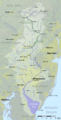
The drainage basin of the Delaware River
Warehouse in New Jersey where trucks deliver granite slabs
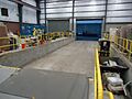
A warehouse in South Jersey

The Delaware Valley is geographically associated and proximate to the Delaware River and its three primary tributaries, the Schuylkill River, Lehigh River, and Brandywine Creek.

U.S. government agencies have reached various definitions of the Delaware Valley and metropolitan Philadelphia. The Office of Management and Budget (OMB) defines metropolitan statistical area (MSAs), which are regions with relatively high population densities at their cores and close economic ties throughout their respective areas. MSAs are further combined into combined statistical areas (CSAs), reflecting commuting patterns. Neither is a formal administrative division.

Metropolitan statistical area (MSA)

Historical population
Census Pop.
1820 171,430
1830 228,203 33.1%
1840 305,278 33.8%
1850 467,053 53.0%
1860 636,029 36.2%
1870 841,230 32.3%
1880 1,062,677 26.3%
1890 1,391,157 30.9%
1900 1,892,496 36.0%
1910 2,268,209 19.9%
1920 2,714,271 19.7%
1930 3,137,040 15.6%
1940 3,299,637 5.2%
1950 3,671,048 11.3%
1960 4,757,462 29.6%
1970 5,317,407 11.8%
1980 5,240,039 −1.5%
1990 5,435,468 3.7%
2000 5,687,147 4.6%
2010 5,965,343 4.9%
2020 6,245,051 4.7%
2022 (est.) 6,241,164 4.6%
U.S. Decennial Census

Philadelphia is located in the Philadelphia-Camden-Wilmington Metropolitan Statistical Area, which includes:

Combined statistical area (CSA)

Philadelphia-Reading-Camden Combined Statistical Area includes:

Delaware Regional Planning Commission

The Delaware Valley Regional Planning Commission (DVRPC) serves all of the counties of the Delaware Valley MSA except for the counties in the Wilmington, DE-MD-NJ Metropolitan Division. However, in addition to the Delaware Valley, DVRPC's jurisdiction includes Mercer County, New Jersey, which OMB classifies as the Trenton-Princeton, NJ MSA and part of the larger New York-Newark CSA.

Population

Boswash
The Delaware Valley is part of the Northeast megalopolis, the second-most highly populated megaregion of the U.S. with 52.3 million residents.

As of the 2020 U.S. census, the Philadelphia-Camden-Wilmington Metropolitan Statistical Area is the seventh-largest MSA in the nation with 6,245,051 people. As of 2020, the Philadelphia–Reading–Camden, PA-NJ-DE-MD CSA is the nation's ninth-largest combined statistical area with a population of 7,379,700,

The Philadelphia-Camden-Wilmington Metropolitan Statistical Area's population of slightly over six million people exceeds the populations of whole nations, including those of Lebanon, Denmark, and Nicaragua.

Economy

As of 2021, the Philadelphia-Camden-Wilmington Metropolitan Statistical Area has a gross domestic product of $477.58 billion, the tenth-largest among the nation's MSAs. The MSA's nominal gross domestic product of $431 billion is comparable to countries, such as Belgium, Iran, and Thailand. Metropolitan Philadelphia is one of the top five American venture capital hubs, credited to its proximity to the New York metropolitan area and its financial and tech and biotechnology ecosystems.

At least two educational institutions, Delaware Valley Regional High School in Alexandria Township, New Jersey, and Delaware Valley College in Doylestown Township, Pennsylvania, and a now defunct local newspaper, The Delaware Valley News in Frenchtown, New Jersey, are named for the region.

Subregions

The Philadelphia-Reading-Camden combined statistical area includes sixteen counties in four states. The five Pennsylvania counties in the metropolitan statistical area are collectively known as Southeastern Pennsylvania. In addition to Philadelphia, major municipalities in Southeastern Pennsylvania include the inner suburbs of Upper Darby Township and Bensalem Township. Berks County, which forms its own MSA and contains the CSA's second largest city, Reading, is occasionally not considered to be part of Southeastern Pennsylvania and is sometimes assigned to South Central Pennsylvania.

The seven New Jersey counties in the CSA are each located in South Jersey, and include: Atlantic County, Cape May County, and Cumberland County each form their own respective metropolitan statistical areas. Atlantic City, Cape May County, New Jersey, and the southern Jersey Shore, including Margate City, Ventnor City, the Wildwoods, and Sea Isle City, are major tourist destinations for people from inside and outside of the Delaware Valley. Other major municipalities in South Jersey include Cherry Hill and Camden, which is across the Delaware River, east of Philadelphia.

The two counties of Delaware in the CSA constitute a majority of Delaware's land mass and population. Wilmington is the most populous city in Delaware and the fifth-most populous municipality in the Delaware Valley. The lone Maryland county in the Philadelphia-Reading-Camden Combined Statistical Area is part of the region known as the Eastern Shore of Maryland.

Media market

The Delaware Valley and several areas bordering it, including the Lehigh Valley, are part of the Philadelphia media market, the fourth-largest media market in the nation as of 2023.

Components of Philadelphia-Camden-Wilmington, PA-NJ-DE-MD Metropolitan Statistical Area

County 2021 Estimate 2020 Census Change Area Density
Philadelphia County 1,576,251 1,603,797 Template:Number table sorting/negative−1.72% 134.28 sq mi (347.8 km2) 11,739/sq mi (4,532/km2)
Montgomery County 860,578 856,553 &10000000000000000469906+0.47% 483 sq mi (1,250 km2) 1,782/sq mi (688/km2)
Bucks County 646,098 646,538 Template:Number table sorting/negative−0.07% 604 sq mi (1,560 km2) 1,070/sq mi (410/km2)
Delaware County 573,849 576,830 Template:Number table sorting/negative−0.52% 184 sq mi (480 km2) 3,119/sq mi (1,204/km2)
New Castle County 571,708 570,719 &10000000000000000173290+0.17% 426 sq mi (1,100 km2) 1,342/sq mi (518/km2)
Chester County 538,649 534,413 &10000000000000000792645+0.79% 751 sq mi (1,950 km2) 717/sq mi (277/km2)
Camden County 523,771 523,485 &10000000000000000054633+0.05% 221.26 sq mi (573.1 km2) 2,367/sq mi (914/km2)
Burlington County 464,269 461,860 &10000000000000000521586+0.52% 798.58 sq mi (2,068.3 km2) 581/sq mi (224/km2)
Gloucester County 304,477 302,294 &10000000000000000722144+0.72% 322 sq mi (830 km2) 946/sq mi (365/km2)
Salem County 65,046 64,837 &10000000000000000322346+0.32% 331.9 sq mi (860 km2) 196/sq mi (76/km2)
Cecil County 103,725 104,870 Template:Number table sorting/negative−1.09% 418 sq mi (1,080 km2) 251/sq mi (97/km2)
Total MSA Population 6,228,601 6,245,051 Template:Number table sorting/negative−0.26% 4,602.02 sq mi (11,919.2 km2) 1,353/sq mi (522/km2)

Additional Components of Philadelphia-Camden-Vineland, PA-NJ-DE-MD Combined Statistical Area

County 2021 Estimate 2020 Census Change Area Density
Berks County 429,342 428,849 &10000000000000000114958+0.11% 857 sq mi (2,220 km2) 501/sq mi (193/km2)
Atlantic County 274,966 274,534 &10000000000000000157357+0.16% 555.7 sq mi (1,439 km2) 495/sq mi (191/km2)
Kent County 184,149 181,851 &10000000000000001263671+1.26% 586 sq mi (1,520 km2) 314/sq mi (121/km2)
Cumberland County 153,627 154,152 Template:Number table sorting/negative−0.34% 483.7 sq mi (1,253 km2) 318/sq mi (123/km2)
Cape May County 95,661 95,263 &10000000000000000417790+0.42% 251.42 sq mi (651.2 km2) 380/sq mi (150/km2)
Total CSA Population 7,366,346 7,379,700 Template:Number table sorting/negative−0.18% 7,335.84 sq mi (18,999.7 km2) 1,004/sq mi (388/km2)

Largest municipalities

Philadelphia skyline from South Street Bridge January 2020 (rotate 2 degrees perspective correction crop 4-1)
Philadelphia, the most populous city in the Delaware Valley and sixth-most populous city in the nation with over 1.6 million residents

The following municipalities are all within the Philadelphia-Reading-Camden combined statistical area and part of the Delaware Valley:

City Pop. County State
Philadelphia 1,567,872 Philadelphia PA
Reading 87,575 Berks PA
Upper Darby Township 82,765 Delaware PA
Camden 74,420 Camden NJ
Wilmington 71,502 New Castle DE
Cherry Hill 70,976 Camden NJ
Gloucester Township 64,049 Camden NJ
Vineland 60,876 Cumberland NJ
Bensalem Township 60,354 Bucks PA
Lower Merion Township 58,220 Montgomery PA
Abington Township 55,640 Montgomery PA
Bristol Township 54,170 Bucks PA
Haverford Township 48,893 Delaware PA
Washington Township 48,301 Gloucester NJ
Evesham Township 45,578 Burlington NJ
Middletown Township 45,318 Bucks PA
Egg Harbor Township 43,747 Atlantic NJ
Mount Laurel 41,849 Burlington NJ
Northampton Township 39,562 Bucks PA
Winslow Township 39,417 Camden NJ

Statistical history

When metropolitan areas were originally defined in 1950, most of the area now in the Delaware Valley was split between four metropolitan areas, or standard metropolitan areas, as they were then called. The Philadelphia SMA included Philadelphia, Bucks, Chester, Delaware, and Montgomery counties in Pennsylvania, and Burlington, Camden, and Gloucester counties in South Jersey. The Wilmington SMA included New Castle County in Delaware and Salem County in South Jersey. Berks County was designated as the Reading SMA and Atlantic County, New Jersey was the Atlantic City SMA.

In 1960, Cecil County, Maryland was added to what was now the Wilmington Standard Metropolitan Statistical Area (SMSA). In 1980, Cumberland County, New Jersey was defined as the Vineland-Millville-Bridgeton SMSA.

In 1990, the Philadelphia, Wilmington and Vineland-Millville-Bridgeton SMSAs were merged with the Trenton SMSA to form the Philadelphia-Wilmington-Trenton Consolidated Metropolitan Statistical Area. At the same time, Cape May County, New Jersey was added to the Atlantic City SMSA. The "Philadelphia-Wilmington-Trenton" became obsolete one census later when Trenton, New Jersey was moved to the New York-Newark-Bridgeport CSA. The Philadelphia-Wilmington-Vineland CSA included the Philadelphia-Wilmington-Camden MSA and the Vineland-Millville-Bridgeton MSA.

In 2000, Kent County, Delaware was designated the Dover MSA, and Kent County and Atlantic City were added to the Philadelphia CSA in 2010. As a result of new 2010 definitions, based on a threshold of 15% labor interchange between MSAs, two additional MSAs were added, Ocean City, New Jersey and Reading, Pennsylvania. The CSA to which they belong is known as Philadelphia-Reading-Camden.

Characteristics

Duffys Cut Cross West Laurel Hill
Grave of some of the 57 Irish victims of Duffy's Cut in West Laurel Hill Cemetery in Bala Cynwyd; Irish Americans make up the largest ethnicity in the Delaware Valley.
Friendship Gate Chinatown Philadelphia from east
Philadelphia's Chinatown, home to many Chinese and Vietnamese restaurants
Hindu Temple Delaware Pic -2
Hindu Temple of Delaware in Hockessin, Delaware

Philadelphia's suburbs contain a high concentration of malls, the two largest of which have at least 5,000,000 square feet (460,000 m2) of office space, and at least 600,000 square feet (56,000 m2) of retail. These are the King of Prussia mall in King of Prussia, Pennsylvania, which is the largest in the U.S. (leasable sq. feet of retail space), and the Cherry Hill Mall in Cherry Hill, New Jersey, which was the first enclosed mall on the East Coast. In addition, the Christiana Mall in Newark, Delaware, is a popular destination due to its proximity to Interstate 95 and because of the availability of tax-free shopping in Delaware. Malls, office complexes, strip shopping plazas, expressways, and tract housing are common sights, and more and more continue to replace rolling countryside, farms, woods, and wetlands. However, due to strong opposition by residents and political officials, many acres of land have been preserved throughout the Delaware Valley. Older townships and large boroughs, such as Cheltenham, Norristown, Jenkintown, Upper Darby, and West Chester retain distinct community identities while engulfed in suburbia. The fastest-growing counties are Chester, Montgomery, Bucks, and Gloucester.

Mid-Atlantic American English and its subset, Philadelphia English, are two common dialects of American English in Philadelphia and the Delaware Valley.

Climate

The Delaware Valley has four distinct seasons with ample precipitation and is divided by the 0 °C (32 °F) January isotherm. Philadelphia and the New Jersey portion of the area, almost all of the Delaware and Maryland portions, most of Delaware County and lower Bucks County, lowland southern Chester County, and some southern and lowland areas of Montgomery County have a humid subtropical climate (Cfa according to the Köppen climate classification.) The remainder of the Delaware Valley has a hot-summer humid continental climate (Dfa.) PRISM Climate Group at Oregon State University

Snow amounts may vary widely year-to-year and normally do vary widely within the Delaware Valley. The region has two ski resorts, Bear Creek Mountain Resort in Longswamp Township, Berks County and Spring Mountain Adventures in central Montgomery County.

Using the -3 °C January isotherm as a boundary, all of the Delaware Valley is humid subtropical. The hardiness zone in the region ranges from 6b in higher areas of Berks and northern Bucks Counties to 8a in Atlantic City and Cape May. [1]

Using the Trewartha climate classification system, which requires eight months to average at least 50 °F for the climate to be considered subtropical, the region only has seven such months, so the area considered Cfa by Köppen is oceanic (Do) in the Trewartha system.

Colonial history

The valley was the territory of the Susquehannock and Lenape, who are recalled in place names throughout the region. The region became part of the Dutch colony of New Netherland after the exploration of Delaware Bay in 1609. The Dutch called the Delaware River the Zuyd Rivier, or South River, and considered the lands along it banks and those of its bay to be the southern flank of its province of New Netherland. In 1638, it began to be settled by Swedes, Forest Finns, Dutch, and Walloons and became the colony of New Sweden, though this was not officially recognized by the Dutch Empire which re-asserted control in 1655. The area was taken by the English in 1664. The name Delaware comes from Thomas West, 3rd Baron De La Warr, who had arrived at Jamestown, Virginia in 1610, just as original settlers were about to abandon it, and thus maintaining the English foothold on the North American continent. In the early 1700s, Huguenot refugees from France by way of Germany and then England began settling in the Delaware River Valley. Specifically, they left their mark in Hunterdon County, New Jersey (Frenchtown) and Bethlehem, Pennsylvania.

Transportation

Many residents commute to jobs and travel in Philadelphia, Camden, Wilmington, and the surrounding suburbs with the help of expressways, trains, and buses. There are currently no transit connections to Reading, the second largest municipality in the region.

Rail

Rapid transit

SEPTA63rdStreetStationPlatform2007
SEPTA's Market–Frankford Line at 63rd Street Station in West Philadelphia
  • SEPTA
    • Market–Frankford Line connecting 69th Street Transportation Center in Upper Darby to Frankford Transportation Center in Near Northeast Philadelphia, passing through Center City
    • Broad Street Line connecting Fern Rock Transportation Center in North Philadelphia to Center City and NRG station in South Philadelphia
    • Norristown High Speed Line connecting 69th Street Transportation Center with Norristown Transportation Center in Norristown
  • PATCO
    • PATCO Speedline connecting Philadelphia to Lindenwold, NJ in Camden County with connections to NJT's Atlantic City Line.

Light rail

  • SEPTA
    • Subway–surface lines: Routes 10, 11, 13, 34, and 36, connecting West Philadelphia and Delaware County with 13th Street Station, running at street-level through Delaware County and West Philadelphia, and beneath Market Street in Center City
    • Route 15 along Girard Avenue from 63rd Street and Girard Avenue to Richmond and Westmoreland Streets
    • Routes 101 and 102 connecting Media (Route 101) and Sharon Hill (Route 102) in Delaware County with 69th Street Transportation Center
  • NJ Transit
    • River Line connecting Camden, New Jersey to Trenton, New Jersey, running along the east bank of the Delaware River.

Commuter rail

30th Street Station concourse March 2019
The grand concourse at Philadelphia's 30th Street Station, which serves Amtrak, SEPTA Regional Rail, and NJ Transit's Atlantic City Line
  • SEPTA Regional Rail
    • Airport Line connecting Central Philadelphia with Philadelphia International Airport in Philadelphia and Delaware Counties.
    • Wilmington/Newark Line connecting Philadelphia to the Wilmington, Delaware area (with limited weekday service to Newark, Delaware), via Chester City and Delaware County.
    • Warminster Line connecting Philadelphia with southeastern Montgomery County and Warminster in Bucks County.
    • West Trenton Line connecting Philadelphia north to the Trenton, New Jersey area, serving Montgomery and Bucks County, Pennsylvania, between Jenkintown and Yardley, Pennsylvania, with the final stop in Ewing, New Jersey.
    • Media/Wawa Line connecting Philadelphia to central Delaware County.
    • Paoli/Thorndale Line connecting Philadelphia with the affluent Main Line area and western Chester County near Coatesville.
    • Lansdale/Doylestown Line connecting Philadelphia with Lansdale in central Montgomery County and Doylestown in Bucks County.
    • Manayunk/Norristown Line connecting Philadelphia with Conshohocken and Norristown in Montgomery County.
    • Cynwyd Line connecting Philadelphia with Bala Cynwyd on the Philadelphia/Montgomery County line (limited weekday service)
    • Trenton Line connecting Philadelphia to Trenton, New Jersey, serving Bucks County.
    • Fox Chase Line connecting Central Philadelphia with the Fox Chase area in Philadelphia.
    • Chestnut Hill East Line and Chestnut Hill West Line connecting Central Philadelphia with the Chestnut Hill area of the city.
  • NJ Transit
  • MARC Train

Intercity rail

Bus service

Transit buses

  • SEPTA
  • NJ Transit
  • South Jersey Transportation Authority
  • DART First State
  • Krapf Transit
  • Bucks County Transport
  • Transportation Management Association of Chester County
  • TMA Bucks
  • Pottstown Area Rapid Transit
  • Berks Area Regional Transportation Authority
  • Cecil Transit
  • Atlantic City casino bus routes by a number of private carriers

Intercity bus

  • Amtrak Thruway
  • BoltBus
  • Greyhound Lines
  • Klein Transportation
  • Martz Trailways
  • Megabus
  • OurBus
  • Peter Pan Bus Lines
  • Trans-Bridge Lines

Major highways

2022-10-09 13 33 59 View east along Interstate 76 and U.S. Route 30 (Schuylkill Expressway) from the overpass for Spring Garden Street in Philadelphia, Pennsylvania
Schuylkill Expressway in Center City Philadelphia

Pennsylvania

  • I-76 (Schuylkill Expressway)
  • I-78
  • I-95 (Delaware Expressway)
  • I-295 (Delaware Expressway)
  • I-176 (Morgantown Expressway)

  • I-76 / I-276 / I-95 / Penna Turnpike
  • I-476 (Blue Route/Mid-County Expressway)

  • I-476 / Penna Turnpike NE Extension
  • I-676 / US 30 (Vine Street Expressway)

  • I-676 / US 30 (Benjamin Franklin Bridge)

  • I-76 (Walt Whitman Bridge)
  • US 1 (Lincoln Expressway/Roosevelt Boulevard/City Line Avenue/Media Bypass/Baltimore Pike/Kennett-Oxford Bypass)
  • US 13
  • US 22
  • US 30 (Lancaster Avenue/Lincoln Highway)
  • US 202 (Wilmington Pike/Highway/Dekalb Pike/Highway/Doylestown Pike/Lower York Road)
  • US 222 (Kutztown Bypass/Outer Bypass/Shillington Bypass)
  • US 322 (Conchester Highway/Downingtown Pike/Horseshoe Pike)
  • US 422 (Pottstown Expressway/Perkiomen Avenue/West Shore Bypass)
  • PA 3 (West Chester Pike/Market Street)
  • PA 10
  • PA 12 (Warren Street Bypass/Pricetown Road)
  • PA 23
  • PA 29
  • PA 32 (River Road)
  • PA 41 (Gap-Newport Pike)
  • PA 52 (Kennett Pike)
  • PA 61 (Centre Avenue/Pottsville Pike)
  • PA 63 (Woodhaven Road/Welsh Road/Sumneytown Pike)
  • PA 73
  • PA 82
  • PA 100 (Pottstown Pike)
  • PA 113
  • PA 132 (Street Road)
  • PA 152 (Limekiln Pike)
  • PA 162
  • PA 179 (Upper York Road)
  • PA 212
  • PA 213
  • PA 232 (Huntingdon Pike/Oxford Ave)
  • PA 252 (Darby Paoli Road/Newtown Street Road/Providence Road)
  • PA 261 (Foulk Road)
  • PA 263 (York Road)
  • PA 272
  • PA 282
  • PA 291 (Industrial Hwy)
  • PA 309 (Fort Washington Expressway/Bethlehem Pike/Sellersville-Souderton Bypass)
  • PA 313
  • PA 320 (Sproul Road)
  • PA 332
  • PA 340
  • PA 345
  • PA 352 (Middletown Road/Chester Road/Edgemont Avenue)
  • PA 363 (Valley Forge Road/Trooper Road)
  • PA 372
  • PA 401 (Conestoga Road)
  • PA 412 (Durham Road)
  • PA 413
  • PA 420 (Woodland Avenue/Kedron Avenue/Wanamaker Avenue)
  • PA 452 (Pennell Road/Market Street)
  • PA 463
  • PA 472
  • PA 491
  • PA 513
  • PA 532 (Washington Crossing Road/Buck Road)
  • PA 562
  • PA 563
  • PA 611 (Doylestown Bypass/Easton Road/Old York Road)
  • PA 663 (John Fries Hwy)
  • PA 724
  • PA 796
  • PA 841
  • PA 842
  • PA 896
  • PA 926 (Street Road)

New Jersey

  • N.J. Turnpike
  • G.S. Parkway
  • A.C. Expressway

  • I-76 (Walt Whitman Bridge)
  • I-295

  • I-676 / US 30 (Benjamin Franklin Bridge)
  • I-76 / I-676 / Route 42 (North-South Freeway)
  • US 9
  • US 30
  • US 40
  • US 130
  • US 206
  • US 322
  • Route 27
  • Route 29
  • Route 31
  • Route 33
  • Route 38
  • Route 44
  • Route 45
  • Route 47
  • Route 48
  • Route 49
  • Route 50
  • Route 52
  • Route 54
  • Route 55
  • Route 56
  • Route 68
  • Route 70
  • Route 72
  • Route 73
  • Route 83
  • Route 87
  • Route 90 (Betsy Ross Bridge)
  • Route 109
  • Route 129
  • Route 133
  • Route 143
  • Route 147
  • Route 152
  • Route 156
  • Route 157
  • Route 168
  • Route 179
  • Route 413

Delaware

  • I-95 / Delaware Turnpike
  • I-295
  • I-495
  • US 13
  • US 40
  • US 113
  • US 202

  • US 301
  • DE 1
  • DE 2
  • DE 3
  • DE 4
  • DE 7
  • DE 9
  • DE 37
  • DE 41
  • DE 48
  • DE 52
  • DE 58
  • DE 62
  • DE 71
  • DE 72
  • DE 82
  • DE 92
  • DE 100
  • DE 141
  • DE 202
  • DE 261
  • DE 273
  • DE 279
  • DE 299
  • DE 491
  • DE 896

Maryland

Delaware River Bridges

Airports

Major:

Secondary:

  • Atlantic City International Airport (ACY)
  • Lehigh Valley International Airport (ABE) (not in CSA)
  • New Castle Airport (ILG)
  • Northeast Philadelphia Airport (PNE)
  • Reading Regional Airport (RDG)
  • Trenton–Mercer Airport (TTN) (not in CSA)

Ferry

The Cape May–Lewes Ferry crosses the mouth of the Delaware Bay between Cape May County, New Jersey and Sussex County, Delaware; U.S. Route 9 uses this ferry.

The Riverlink Ferry operates hourly ferry service over the Delaware River between the Camden Waterfront and Penn’s Landing in Philadelphia. They also operate a special event service for concerts at Freedom Mortgage Pavilion in Camden.

Colleges and universities

Parrish Hall at Swarthmore College and Cohen Hall, previously named Logan Hall, former home of the Wharton School of the University of Pennsylvania. The Wharton School is consistently ranked as the best business school in the world.

Delaware

Maryland

  • Cecil College

New Jersey

  • Rider University
  • Rowan University
  • Rutgers School of Law–Camden
  • Rutgers University (Camden)
  • Stockton University
  • The College of New Jersey

Pennsylvania

Culture

Sports teams

Listing of the professional sports teams in the Delaware Valley

Media

The two main newspapers are The Philadelphia Inquirer and the Philadelphia Daily News, owned by the Philadelphia Media Network. Local television channels include KYW-TV 3 (CBS), WPVI 6 (ABC), WCAU 10 (NBC), WHYY-TV 12 (PBS), WPHL-TV 17 (MyNetworkTV), WTXF 29 (FOX), WPSG 57 (CW), and WPPX 61 (Ion). Radio stations serving the area include: WRTI, WIOQ, WDAS (AM), and WTEL.


Area codes

  • 215/267/445: The City of Philadelphia and some of its northern suburbs
  • 610/484/835: Southeastern Pennsylvania outside Philadelphia, including the western suburbs, the Lehigh Valley, and most of Berks County
  • 856: Southwestern New Jersey, including Camden, Cherry Hill, and Vineland
  • 609/640: Central and Southeastern New Jersey, including Trenton, Atlantic City and the southern Jersey Shore
  • 302: Delaware
  • 410/443/667: Eastern half of Maryland, including Cecil County
  • 717/223: South Central Pennsylvania, including Western Berks County

See also

Kids robot.svg In Spanish: Valle de Delaware para niños

kids search engine
Delaware Valley Facts for Kids. Kiddle Encyclopedia.