New Britain, Pennsylvania facts for kids
Quick facts for kids
New Britain, Pennsylvania
|
||
|---|---|---|

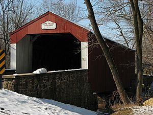
Pine Valley Covered Bridge
|
||
|
||
| Motto(s):
"A Friendly Place to Live"
|
||

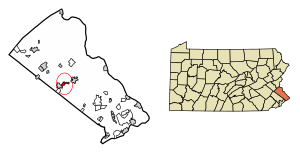
Location of New Britain in Bucks County, Pennsylvania
|
||
| Country | United States | |
| State | Pennsylvania | |
| County | Bucks | |
| Government | ||
| • Body | Borough Council | |
| Area | ||
| • Total | 1.21 sq mi (3.13 km2) | |
| • Land | 1.21 sq mi (3.13 km2) | |
| • Water | 0.00 sq mi (0.01 km2) | |
| Elevation | 276 ft (84 m) | |
| Population
(2020)
|
||
| • Total | 2,836 | |
| • Density | 2,349.63/sq mi (907.10/km2) | |
| Time zone | UTC-5 (Eastern (EST)) | |
| • Summer (DST) | UTC-4 (EDT) | |
| ZIP Code |
18901
|
|
| Area codes | 215, 267 and 445 | |
| FIPS code | 42-53296 | |
New Britain is a small town, called a borough, located in Bucks County, Pennsylvania, in the United States. In 2020, about 2,836 people lived there. It's known for its friendly atmosphere.
Contents
Exploring New Britain's Location
New Britain is found at specific coordinates: 40.299256 degrees North and -75.178224 degrees West. This helps us pinpoint its exact spot on a map.
Natural Features Around New Britain
The borough is home to some lovely natural spots. These include Cooks Run and the Neshaminy Creek. New Britain covers about 1.3 square miles (3.4 square kilometers) of land.
A Glimpse into New Britain's Past
New Britain has a rich history, dating back to the 1700s.
Early Settlements and Important Buildings
Around 1731, a man named Eugene James built a large estate. This estate included the Mathews homestead, a beautiful old house built in 1744. The village of James Manor started on this estate. Other nearby villages were Jamestown, New Britain, and Vauxtown.
The Delaware Valley University, which was once called the National Farm School, was built close to James Manor.
Historic Events and Famous Visitors
An old tavern called "The Sign of the Horses and Wagon" was a significant place. It was here that Marquis de Lafayette, a French hero who helped America, stayed. This was when the Continental Army marched from Valley Forge to Monmouth, New Jersey, during the American Revolutionary War.
The very first home in the village of New Britain was built before 1760. It was located where West Butler Avenue (U.S. Route 202) and Almshouse Road meet.
How New Britain Got Its Name
For a short time, the village was known as Bittings Store or Bittings Corner. Many early residents were part of the Montgomery Baptist Church. Around 1740, they formed their own church, calling it the Society Meeting House. By 1813, its name changed to the New Britain Baptist Church.
Becoming an Official Borough
The North Pennsylvania Railroad station opened in 1856, with the name "New Brittain" on its sign. A post office was set up in 1829. New Britain officially became a borough on May 21, 1928. It brought together the villages of James Manor, Jamestown, New Britain, and part of Vauxtown.
Who Lives in New Britain?
The number of people living in New Britain has changed over the years.
| Historical population | |||
|---|---|---|---|
| Census | Pop. | %± | |
| 1880 | 119 | — | |
| 1930 | 417 | — | |
| 1940 | 476 | 14.1% | |
| 1950 | 581 | 22.1% | |
| 1960 | 1,109 | 90.9% | |
| 1970 | 2,428 | 118.9% | |
| 1980 | 2,519 | 3.7% | |
| 1990 | 2,174 | −13.7% | |
| 2000 | 3,125 | 43.7% | |
| 2010 | 3,152 | 0.9% | |
| 2020 | 2,836 | −10.0% | |
| Sources: | |||
In 2010, most people living in New Britain were White (92.7%). There were also smaller groups of Black or African American, Asian, Native American, and Pacific Islander residents. About 2.7% of the population had Hispanic or Latino family backgrounds.
In 2000, there were 3,125 people living in the borough. About 32.7% of homes had children under 18. The average home had about 2.58 people. The median age of residents was 28 years old.
Understanding New Britain's Weather
New Britain has a climate with hot summers. This type of climate is called a Humid continental climate.
Summer Weather in New Britain
Even though most summer days are a bit humid, it can get very hot and sticky. The highest temperature recorded since 1981 was 102.7°F (39.3°C) on July 22, 2011. July is usually the wettest month, with many thunderstorms. The most rain in one day was 6.93 inches (176 mm) on September 16, 1999.
Winter Weather in New Britain
During winter, the average coldest temperature is around -0.6°F (-18.1°C). The coldest temperature recorded since 1981 was -12.1°F (-24.5°C) on January 22, 1984. Sometimes, it can feel even colder due to strong winds. New Britain usually gets between 30 and 36 inches (76 to 91 cm) of snow each winter. Big snowstorms with more than 12 inches (30 cm) of snow happen every few years.
| Climate data for New Britain, Elevation 289 ft (88 m), 1981-2010 normals, extremes 1981-2018 | |||||||||||||
|---|---|---|---|---|---|---|---|---|---|---|---|---|---|
| Month | Jan | Feb | Mar | Apr | May | Jun | Jul | Aug | Sep | Oct | Nov | Dec | Year |
| Record high °F (°C) | 70.9 (21.6) |
77.9 (25.5) |
86.9 (30.5) |
93.8 (34.3) |
94.7 (34.8) |
95.7 (35.4) |
102.7 (39.3) |
99.6 (37.6) |
97.4 (36.3) |
89.2 (31.8) |
80.8 (27.1) |
75.2 (24.0) |
102.7 (39.3) |
| Mean daily maximum °F (°C) | 39.2 (4.0) |
42.4 (5.8) |
50.8 (10.4) |
62.8 (17.1) |
72.8 (22.7) |
81.6 (27.6) |
85.7 (29.8) |
84.0 (28.9) |
77.1 (25.1) |
65.7 (18.7) |
54.7 (12.6) |
43.3 (6.3) |
63.4 (17.4) |
| Daily mean °F (°C) | 30.4 (−0.9) |
33.2 (0.7) |
40.9 (4.9) |
51.6 (10.9) |
61.3 (16.3) |
70.5 (21.4) |
75.0 (23.9) |
73.5 (23.1) |
66.1 (18.9) |
54.3 (12.4) |
44.7 (7.1) |
34.8 (1.6) |
53.1 (11.7) |
| Mean daily minimum °F (°C) | 21.7 (−5.7) |
24.1 (−4.4) |
30.9 (−0.6) |
40.4 (4.7) |
49.8 (9.9) |
59.4 (15.2) |
64.3 (17.9) |
62.9 (17.2) |
55.1 (12.8) |
42.9 (6.1) |
34.7 (1.5) |
26.3 (−3.2) |
42.8 (6.0) |
| Record low °F (°C) | −12.1 (−24.5) |
−4.4 (−20.2) |
2.4 (−16.4) |
16.5 (−8.6) |
32.8 (0.4) |
40.6 (4.8) |
47.2 (8.4) |
41.9 (5.5) |
34.7 (1.5) |
23.4 (−4.8) |
10.9 (−11.7) |
−2.8 (−19.3) |
−12.1 (−24.5) |
| Average precipitation inches (mm) | 3.24 (82) |
2.63 (67) |
3.72 (94) |
3.92 (100) |
4.34 (110) |
4.30 (109) |
4.97 (126) |
4.05 (103) |
4.46 (113) |
4.21 (107) |
3.63 (92) |
3.91 (99) |
47.38 (1,203) |
| Average relative humidity (%) | 66.6 | 63.4 | 58.8 | 58.0 | 62.3 | 67.2 | 67.5 | 69.7 | 71.2 | 70.2 | 68.9 | 68.5 | 66.0 |
| Average dew point °F (°C) | 20.6 (−6.3) |
22.1 (−5.5) |
27.6 (−2.4) |
37.3 (2.9) |
48.3 (9.1) |
59.1 (15.1) |
63.5 (17.5) |
63.0 (17.2) |
56.5 (13.6) |
44.8 (7.1) |
35.1 (1.7) |
25.5 (−3.6) |
42.0 (5.6) |
| Source: PRISM | |||||||||||||
Getting Around New Britain
New Britain has a good network of roads and public transport.
Roads in New Britain
As of 2018, New Britain had about 12.30 miles (19.79 kilometers) of public roads. Some roads are kept up by the Pennsylvania Department of Transportation (PennDOT), and others by the borough itself.
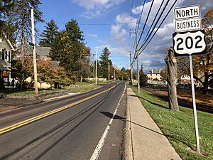
The main highway that goes through New Britain is U.S. Route 202 Business. It runs from the southwest to the northeast along Butler Avenue.
Public Transportation Options
New Britain is served by the New Britain station on SEPTA Regional Rail's Lansdale/Doylestown Line. This train line connects New Britain to Doylestown and Center City Philadelphia.
Bucks County Transport also runs a bus called the DART West bus. This bus operates on weekdays and can take you from Chalfont to a connection with another bus, the Doylestown DART bus, which goes to Doylestown.
Nature and Plants in New Britain
New Britain's natural environment is mostly covered by Oak trees. This type of forest is called an Eastern Hardwood Forest.
Plant Life and Seasons
The area is in a plant hardiness zone where the average coldest temperature is about -0.6°F (-18.1°C). This means certain plants can grow well here. Spring flowers usually start to bloom around April 11. The beautiful fall colors in the trees typically reach their peak around October 30.
Famous People from New Britain
- Samuel Aaron was an American educator and a Baptist minister.
See also
 In Spanish: New Britain (Pensilvania) para niños
 | Leon Lynch |
 | Milton P. Webster |
 | Ferdinand Smith |


