Hatfield, Pennsylvania facts for kids
Quick facts for kids
Borough of Hatfield
|
|||
|---|---|---|---|

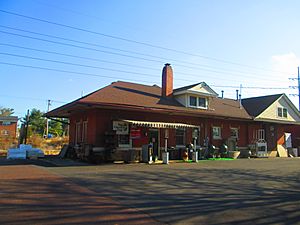
Former Reading station
|
|||
|
|||

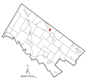
Location of Hatfield in Montgomery County, Pennsylvania.
|
|||
| Country | United States | ||
| State | Pennsylvania | ||
| County | Montgomery | ||
| Government | |||
| • Type | Council-manager | ||
| Area | |||
| • Total | 0.64 sq mi (1.67 km2) | ||
| • Land | 0.64 sq mi (1.67 km2) | ||
| • Water | 0.00 sq mi (0.00 km2) | ||
| Elevation | 335 ft (102 m) | ||
| Population
(2020)
|
|||
| • Total | 3,496 | ||
| • Density | 5,437.01/sq mi (2,098.83/km2) | ||
| Time zone | UTC-5 (EST) | ||
| • Summer (DST) | UTC-4 (EDT) | ||
| ZIP Code |
19440
|
||
| Area codes | 215, 267, and 445 | ||
| FIPS code | 42-33112 | ||
Hatfield is a small town, called a borough, in Montgomery County, Pennsylvania, United States. It's home to 3,496 people, according to the 2020 census. Hatfield is part of the North Penn Valley area, which is centered around the town of Lansdale. The borough is completely surrounded by Hatfield Township.
Contents
Geography of Hatfield
Hatfield is a small place, covering about 0.6 square miles (1.6 square kilometers). All of this area is land. There are no large bodies of water within the borough limits.
People of Hatfield
Hatfield's population has grown steadily over the years. In 1900, there were 528 people living here. By 2020, the population had reached 3,496.
| Historical population | |||
|---|---|---|---|
| Census | Pop. | %± | |
| 1900 | 528 | — | |
| 1910 | 705 | 33.5% | |
| 1920 | 830 | 17.7% | |
| 1930 | 1,149 | 38.4% | |
| 1940 | 1,301 | 13.2% | |
| 1950 | 1,624 | 24.8% | |
| 1960 | 1,941 | 19.5% | |
| 1970 | 2,385 | 22.9% | |
| 1980 | 2,533 | 6.2% | |
| 1990 | 2,650 | 4.6% | |
| 2000 | 2,605 | −1.7% | |
| 2010 | 3,290 | 26.3% | |
| 2020 | 3,496 | 6.3% | |
In 2010, most of the people living in Hatfield were White (66.6%). There were also people who identified as Asian (23.5%), Black or African American (4.1%), and Native American (0.1%). About 2.9% of the population identified as two or more races. Around 6.8% of the people in Hatfield were of Hispanic or Latino background.
The average age in Hatfield in 2000 was 35 years old. About 23.2% of the population was under 18 years old.
Education in Hatfield
Students in Hatfield attend schools in the North Penn School District. Hatfield Elementary School is located nearby in Hatfield Township.
St. Maria Goretti School, a private school, used to be in Hatfield. It closed in 2012, but the church is still open.
Economy of Hatfield
Penn Beer, a company that sells and services beverages, has a center in Hatfield. It is located in a building that used to be a plant for Cemco Lift.
Getting Around Hatfield
Roads in Hatfield
Hatfield has about 8.80 miles (14.16 km) of public roads. Some roads are kept up by the state, and others by the borough itself.
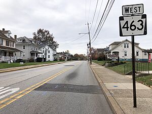
The main roads in Hatfield are Broad Street and Main Street. Broad Street runs southwest to northeast. Main Street runs northwest to southeast. Pennsylvania Route 463 goes through Hatfield, using parts of Broad Street and Main Street.
Other important roads nearby include Pennsylvania Route 309. The Lansdale exit for the Pennsylvania Turnpike Northeast Extension (Interstate 476) is also close to Hatfield.
Public Transportation in Hatfield
Hatfield has a rail line that used to be part of the Reading Company. This line connects Hatfield to towns like Souderton and Lansdale. It is still used for moving goods by train. Sometimes, special scenic train rides also use this line. People are even thinking about bringing back regular passenger train service to Quakertown.
You can also get around Hatfield using the SEPTA Suburban Bus Route 132. This bus goes north to Souderton and Telford, and south to Lansdale and the Montgomery Mall.
Utilities in Hatfield
The Borough of Hatfield Electric Utility provides electricity to the town. Natural gas is supplied by PECO Energy Company. The North Penn Water Authority provides water to Hatfield and nearby areas. The Borough of Hatfield Sewer Utility handles sewer services. For trash and recycling, residents use private companies like Republic Services and Waste Management.
Notable People from Hatfield
- Brandon McManus: A professional football player who plays for the Denver Broncos.
- Jim Molinaro: A former professional football player who played for the Washington Redskins.
- Nancy Raabe: A composer, author, and clergy member at Grace Lutheran Church.
See also
 In Spanish: Hatfield (Pensilvania) para niños
 | Roy Wilkins |
 | John Lewis |
 | Linda Carol Brown |


