Cooks Run (Neshaminy Creek tributary) facts for kids
Quick facts for kids Cooks Run |
|
|---|---|
|
Cooks Run
|
|
| Country | United States |
| State | Pennsylvania |
| County | Bucks |
| Township | Doylestown New Britain |
| Physical characteristics | |
| Main source | 340 feet (100 m) 40°19′9″N 75°8′8″W / 40.31917°N 75.13556°W |
| River mouth | 226 feet (69 m) 40°17′32″N 75°10′52″W / 40.29222°N 75.18111°W |
| Length | 2.2 miles (3.5 km) |
| Basin features | |
| Progression | Cooks Run → Neshaminy Creek → Delaware River → Delaware Bay |
| River system | Delaware River |
| Basin size | 3.32 square miles (8.6 km2) |
| Landmarks | Wilma Quinlan Nature Preserve |
| Bridges | Burpee Road North Shady Retreat Road Ironhill Road Business U.S. Route 202 (East Butler Avenue) Almshouse Road (South Tamenand Avenue) |
| Slope | 51.82 feet per mile (9.814 m/km) |
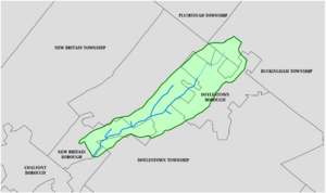
Cooks Run is a small stream, also called a tributary, that flows into the Neshaminy Creek. It starts in Doylestown Township, which is in Bucks County, Pennsylvania. The stream is about 2 miles (3.2 km) long before it joins the Neshaminy Creek.
Contents
What's in a Name? The History of Cooks Run
Cooks Run got its name from Arthur Cooke. He was a very important landowner in Bucks County way back in the late 1600s.
This stream was once super important for power! It helped run three different mills. These mills were places that used water power to grind grain or do other work.
Where Does Cooks Run Flow?
Cooks Run begins near Pennsylvania Route 611 and the Doylestown Hospital. It flows generally southwest.
Finally, it meets the Neshaminy Creek at a spot called Miller Point. This area is part of the Wilma Quinlan Nature Preserve.
Facts and Figures About Cooks Run
Cooks Run joins the Neshaminy Creek about 38.10 miles (61.32 km) from where the Neshaminy Creek starts. The area of land that drains water into Cooks Run is called its watershed. This watershed covers about 3.32 square miles (8.6 km²).
The stream is classified as a Warmwater Fishery (WWF). This means its waters are suitable for fish that prefer warmer temperatures. It's also a Migratory Fishery (MF), which means fish that travel to different places use it.
Both Cooks Run and the Neshaminy Creek are on a special list. This list, called the State's 303(d) List, shows waters that need improvement in their quality.
Towns and Areas Cooks Run Flows Through
Cooks Run flows through parts of Bucks County.
- New Britain
- Doylestown Township
Bridges Over Cooks Run
Many roads cross over Cooks Run using bridges. Here are some of them:
- Almshouse Road (South Tamenend Avenue)
- Business U.S. Route 202 (East Butler Avenue)
- Iron Hill Road
- North Shady Retreat Road
- Burpee Road
 | Madam C. J. Walker |
 | Janet Emerson Bashen |
 | Annie Turnbo Malone |
 | Maggie L. Walker |


