Park Creek (Little Neshaminy Creek tributary) facts for kids
Quick facts for kids Park Creek |
|
|---|---|

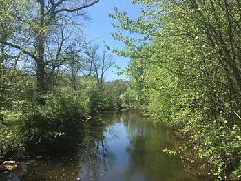
Park Creek in Kohler Park in Horsham Township, Pennsylvania
|
|
|
Park Creek
|
|
| Country | United States |
| State | Pennsylvania |
| County | Bucks |
| Township | Doylestown New Britain |
| Physical characteristics | |
| Main source | 400 feet (120 m) 40°13′15″N 75°13′57″W / 40.22083°N 75.23250°W |
| River mouth | 220 feet (67 m) 40°13′24″N 75°8′41″W / 40.22333°N 75.14472°W |
| Length | 6.36 miles (10.24 km) |
| Basin features | |
| Progression | Park Creek → Little Neshaminy Creek → Neshaminy Creek → Delaware River → Delaware Bay |
| River system | Delaware River |
| Basin size | 11.8 square miles (31 km2) |
| Landmarks | Springhouse Quarry Cedar Hill Rd Park Kohler Park Whitemarsh Memorial Park Deep Meadow Park Carpenter Park Graeme Park Strawbridge Park |
| Bridges | See table |
| Slope (Main Branch) | 28.3 feet per mile (5.36 m/km) |
Park Creek is a small stream in Pennsylvania, USA. It flows into the Little Neshaminy Creek. This creek is part of the larger Delaware River system. The water from Park Creek eventually reaches the Delaware Bay.
Contents
About Park Creek
Park Creek is an important part of the local environment. It helps drain water from a large area. This area is called its watershed.
Where Does the Name Come From?
Park Creek gets its name from Graeme Park. This historic park is located near Horsham, Pennsylvania.
Key Facts and Figures
The area that drains into Park Creek is about 11.80 square miles (30.6 km2). This watershed includes suburban areas. It passes through several townships. These include Warrington, Horsham, Montgomery, and Lower Gwynedd.
The creek's official identification number is 1183295. This number is from the U.S. Department of the Interior Geological Survey.
The Creek's Journey
Park Creek has two main branches that come together.
Northern Branch
The northern branch starts near Hartman Road. This is in Montgomery Township. It flows southeast for about 0.83 miles (1.34 km). Then it turns east for 0.63 miles (1.01 km). After that, it flows southeast again for 1.35 miles (2.17 km). It then meets the west branch.
Western Branch
The west branch begins near Tennis Avenue. This is in Lower Gwynedd Township. It flows northeast for about 1.75 miles (2.82 km). It then joins the northern branch.
Main Course
When the two branches meet, they form the main part of Park Creek. This main creek flows northeast for 2.67 miles (4.30 km). It eventually joins the Little Neshaminy Creek. Along its way, the main creek flows through several parks. These include Kohler Park and Deep Meadow Park. It also runs along the edge of Graeme Park.
Areas Park Creek Flows Through
Park Creek flows through different parts of Pennsylvania. These areas are in two counties:
- Bucks County
- Warrington Township
- Montgomery County
- Horsham Township
- Montgomery Township
- Lower Gwynedd Township
Bridges Over Park Creek
Many roads cross over Park Creek. Here are some of the bridges:
| Crossing | Length | Lanes | Spans | Material/Design | Built |
|---|---|---|---|---|---|
| Main Branch | |||||
| Pennsylvania Route 463 (Horsham Road) | - | - | - | - | - |
| Davis Grove Road | - | - | - | - | - |
| Keith Valley Road | - | - | - | - | - |
| County Line Road | 17 metres (56 ft) | 2 | 1 | Box beam or girders - multiple design, prestressed concrete | 1985 |
| West Branch Park Creek | |||||
| Pennsylvania Route 63 (Welsh Road) | - | - | - | - | - |
| Talamore Drive | - | - | - | - | - |
| Pennsylvania Route 152 (Limekiln Pike) | 10 metres (33 ft) | 2 | 1 | Tee Beam design, concrete construction | 1928 |
| North Branch Park Creek | |||||
| Hartman Road (SR 2014) | - | - | - | - | - |
| Regency Drive | - | - | - | - | - |
| Lower State Road | - | - | - | - | - |
| Cedar Hill Road | 20 metres (66 ft) | 2 | 1 | Box beam or girder - single or spread, prestressed concrete | 2003 |
| Pennsylvania Route 152 (Limekiln Pike) | - | - | - | - | - |
 | Emma Amos |
 | Edward Mitchell Bannister |
 | Larry D. Alexander |
 | Ernie Barnes |


