
Morrisville, Bucks County, Pennsylvania facts for kids
Quick facts for kids
Morrisville, Pennsylvania
|
||
|---|---|---|
|
Borough
|
||
,_Morrisville_(Bucks_County,_Pennsylvania).jpg)
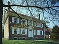
Summerseat, home of Robert Morris
|
||
|
||

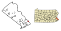
Location in Bucks County, Pennsylvania
|
||

Morrisville, Pennsylvania
Location in Pennsylvania

Morrisville, Pennsylvania
Location in the United States
|
||
| Country | United States | |
| State | Pennsylvania | |
| County | Bucks | |
| Settled | 1624 | |
| Named for | Robert Morris | |
| Area | ||
| • Total | 1.95 sq mi (5.05 km2) | |
| • Land | 1.75 sq mi (4.52 km2) | |
| • Water | 0.20 sq mi (0.52 km2) | |
| Elevation | 56 ft (17 m) | |
| Population
(2020)
|
||
| • Total | 9,809 | |
| • Density | 5,614.77/sq mi (2,168.22/km2) | |
| Time zone | UTC-5 (EST) | |
| • Summer (DST) | UTC-4 (EDT) | |
| ZIP Code |
19067
|
|
| Area code | 215 | |
| FIPS code | 42-51144 | |
| GNIS feature ID | 1214970 | |

Morrisville is a small town, called a borough, in Bucks County, Pennsylvania, United States. It is located right across the Delaware River from Trenton, New Jersey. In 2020, about 9,809 people lived here.
Morrisville is about 27 miles (43 km) northeast of Philadelphia. It is also about 46 miles (74 km) southeast of Allentown.
Contents
History of Morrisville
The first known settlement in this area was a trading post. It was run by the Dutch West India Company from 1624 to 1627. This post was on an island in the Delaware River.
In its early days, the area was called Crewcorne. It was part of Falls Township. Later, one of the first ferries to cross the Delaware River started here. By the late 1700s, a small community grew around this ferry crossing. It was then known as Colvin's Ferry.
In 1804, the settlement officially became a borough. It was named Morrisville after Robert Morris. He was one of America's Founding Fathers. In the same year, construction began on the first bridge across the Delaware River. This bridge connected Morrisville to Trenton. It opened for traffic in 1806.
Several historic places in Morrisville are very important. These include the Gershom Craft House, Summerseat, and the Trenton City/Calhoun Street Bridge. They are listed on the National Register of Historic Places. Summerseat is also a National Historic Landmark.
Morrisville is also home to Graystones. This historic site marks where William Penn first bought land in Pennsylvania. He bought it from the Lenape Native American tribe.
At one time, Morrisville was even considered to be the nation's capital. Robert Morris worked to make the new capital at the "Falls of the Delaware." He preferred it to be on the Pennsylvania side of the river. You can see the Delaware River from Park Avenue in Morrisville. Just below is the famous Falls of the Delaware.
Geography and Location
Morrisville is located at 40°12′27″N 74°46′48″W / 40.20750°N 74.78000°W. It is part of a unique area that is mostly surrounded by New Jersey.
Morrisville was originally a village within Falls Township. In 1804, it became its own borough. Morrisville is bordered by Falls Township to the south. Lower Makefield Township is to the north. The Delaware River forms its eastern border.
The town's name is the main city name for the 19067 ZIP code. This ZIP code covers areas like Yardley, Lower Makefield, Morrisville, and part of Falls Township.
The borough covers about 2.0 square miles (5.1 km2). Most of this area, about 1.8 square miles (4.6 km2), is land. The rest, about 0.2 square miles (0.5 km2), is water.
Parks and Green Spaces
Morrisville has several parks. The Delaware Canal State Park runs along the eastern edge of the town.
- Williamson Park: This park is located between the Calhoun Street Bridge and the Lower Trenton Bridge. It is home to Morrisville Little League. Many community events are held here.
- Graystones Woods: Next to Graystones is a wooded area. It stretches from the Delaware Canal to Crown Street in the northern part of town.
- Morrisville Riverfront Preserve: This 8.8-acre area is south of the Trenton–Morrisville Toll Bridge. It protects some of the last parts of the Delaware River's tidal basin.
- Morrisville Dog Park: This park has two fenced areas for dogs to play.
Population and People
| Historical population | |||
|---|---|---|---|
| Census | Pop. | %± | |
| 1810 | 266 | — | |
| 1820 | 391 | 47.0% | |
| 1830 | 531 | 35.8% | |
| 1840 | 405 | −23.7% | |
| 1850 | 565 | 39.5% | |
| 1860 | 784 | 38.8% | |
| 1870 | 813 | 3.7% | |
| 1880 | 968 | 19.1% | |
| 1890 | 1,208 | 24.8% | |
| 1900 | 1,371 | 13.5% | |
| 1910 | 2,002 | 46.0% | |
| 1920 | 3,639 | 81.8% | |
| 1930 | 5,368 | 47.5% | |
| 1940 | 5,493 | 2.3% | |
| 1950 | 6,787 | 23.6% | |
| 1960 | 7,790 | 14.8% | |
| 1970 | 11,309 | 45.2% | |
| 1980 | 9,845 | −12.9% | |
| 1990 | 9,765 | −0.8% | |
| 2000 | 10,023 | 2.6% | |
| 2010 | 8,728 | −12.9% | |
| 2020 | 9,809 | 12.4% | |
| Sources: | |||
As of the 2020 census, 9,089 people lived in Morrisville. The average family size was about 2.88 people.
The median age of residents was 40 years old. About 14.9% of the people were 65 years old or older.
The average income for a household was $81,028. About 6.7% of residents lived below the poverty line.
Education in Morrisville
The local schools in Morrisville are part of the Morrisville School District.
Why it's Called Morrisville
The borough is named after Robert Morris. He was an American Founding Father, a merchant, and a banker. Robert Morris was the main person who helped pay for the American Revolution. His historic home, Summerseat, is still in town.
Sports Achievements
In 1955, the Morrisville Little League baseball team won a big championship. They defeated Merchantville, New Jersey to win the Little League World Series title. Morrisville is one of only four teams from Pennsylvania to have won this tournament. The tournament started in 1947.
Transportation Options
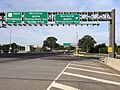
_at_the_exit_for_Pennsylvania_Avenue_NORTH_(Morrisville)_in_Morrisville,_Bucks_County,_Pennsylvania.jpg)
As of 2019, Morrisville had about 32.16 miles (51.76 km) of public roads. The Pennsylvania Department of Transportation (PennDOT) maintained 6.25 miles (10.06 km). The borough maintained the other 25.91 miles (41.70 km).
U.S. Route 1 is the main highway in Morrisville. It runs through the southeastern part of the borough. This route crosses the Delaware River into New Jersey using the Trenton–Morrisville Toll Bridge. Pennsylvania Route 32 also goes through Morrisville. It follows Bridge Street, Delmorr Avenue, and River Road.
SEPTA provides bus service to Morrisville. Route 127 runs between the Oxford Valley Mall near Langhorne and the Trenton Transit Center in Trenton, New Jersey.
Amtrak's Northeast Corridor and SEPTA Regional Rail's Trenton Line trains pass through Morrisville. However, there are no train stations directly in the borough. The closest station is the Trenton Transit Center. This station serves Amtrak, SEPTA Regional Rail, and NJ Transit trains and buses.
Climate and Weather
Morrisville has a Humid subtropical climate (Cfa). This means it has hot, humid summers and mild winters. All months have an average temperature above 32.0°F (0°C). At least four months have an average temperature of 50.0°F (10°C) or higher. At least one month has an average temperature of 71.6°F (22°C) or higher. There isn't a big difference in rainfall between seasons.
Summers can be quite humid. Very hot and humid days can occur, with heat index values over 108°F (42°C). The highest temperature recorded since 1981 was 103.2°F (39.6°C) on July 6, 2010.
The wettest month on average is July. This is when thunderstorms are most common. The most rain in one day since 1981 was 6.35 inches (161 mm) on August 27, 2011, during Hurricane Irene.
During winter, the average coldest temperature is about 1.6°F (-16.9°C). The coldest temperature recorded since 1981 was -10.3°F (-23.5°C) on January 22, 1984. Sometimes, it can get very cold and windy. Wind chill values can drop below -9°F (-23°C).
Morrisville gets about 24 to 30 inches (61 to 76 cm) of snow each winter (November to April). Ice storms and large snowstorms with 12 inches (30 cm) or more of snow happen every few years. These often occur during nor’easter storms.
| Climate data for Morrisville, Elevation 46 ft (14 m), 1991-2020 normals, extremes 1981-2018 | |||||||||||||
|---|---|---|---|---|---|---|---|---|---|---|---|---|---|
| Month | Jan | Feb | Mar | Apr | May | Jun | Jul | Aug | Sep | Oct | Nov | Dec | Year |
| Record high °F (°C) | 71.7 (22.1) |
77.9 (25.5) |
87.8 (31.0) |
94.7 (34.8) |
95.6 (35.3) |
96.9 (36.1) |
103.2 (39.6) |
100.5 (38.1) |
98.3 (36.8) |
89.3 (31.8) |
81.1 (27.3) |
76.1 (24.5) |
103.2 (39.6) |
| Mean daily maximum °F (°C) | 40.7 (4.8) |
43.4 (6.3) |
51.5 (10.8) |
63.7 (17.6) |
73.0 (22.8) |
82.4 (28.0) |
86.6 (30.3) |
84.9 (29.4) |
77.9 (25.5) |
66.8 (19.3) |
55.8 (13.2) |
44.8 (7.1) |
64.3 (17.9) |
| Daily mean °F (°C) | 32.4 (0.2) |
34.5 (1.4) |
41.8 (5.4) |
52.5 (11.4) |
61.8 (16.6) |
71.3 (21.8) |
76.0 (24.4) |
74.4 (23.6) |
67.2 (19.6) |
55.7 (13.2) |
46.2 (7.9) |
36.5 (2.5) |
54.2 (12.3) |
| Mean daily minimum °F (°C) | 24.2 (−4.3) |
25.6 (−3.6) |
32.1 (0.1) |
41.3 (5.2) |
50.6 (10.3) |
60.3 (15.7) |
65.3 (18.5) |
64.0 (17.8) |
56.5 (13.6) |
44.7 (7.1) |
36.6 (2.6) |
28.3 (−2.1) |
44.2 (6.8) |
| Record low °F (°C) | −10.3 (−23.5) |
−2.4 (−19.1) |
4.4 (−15.3) |
18.0 (−7.8) |
32.8 (0.4) |
41.2 (5.1) |
47.3 (8.5) |
42.3 (5.7) |
36.1 (2.3) |
25.0 (−3.9) |
11.7 (−11.3) |
0.5 (−17.5) |
−10.3 (−23.5) |
| Average precipitation inches (mm) | 3.54 (90) |
2.80 (71) |
4.32 (110) |
3.97 (101) |
4.10 (104) |
4.39 (112) |
5.30 (135) |
4.20 (107) |
4.38 (111) |
3.69 (94) |
3.54 (90) |
4.05 (103) |
48.28 (1,226) |
| Average relative humidity (%) | 65.4 | 61.7 | 57.8 | 57.0 | 62.1 | 66.1 | 66.2 | 68.6 | 69.8 | 68.8 | 66.9 | 66.8 | 64.8 |
| Average dew point °F (°C) | 21.6 (−5.8) |
22.7 (−5.2) |
28.0 (−2.2) |
37.7 (3.2) |
48.7 (9.3) |
59.5 (15.3) |
63.9 (17.7) |
63.4 (17.4) |
57.0 (13.9) |
45.6 (7.6) |
35.8 (2.1) |
26.5 (−3.1) |
42.6 (5.9) |
| Source: PRISM | |||||||||||||
Ecology and Nature
Morrisville's natural plant life would mostly be Oak trees. It would be an Eastern Hardwood Forest. The area's plant hardiness zone is 7a. This means the average coldest temperature in winter is about 1.6°F (-16.9°C).
Spring flowers usually start to bloom around April 8. The beautiful fall colors in the trees typically reach their peak around November 3.
Famous People from Morrisville
Morrisville has been the home or birthplace of several well-known Americans:
- Thomas Barclay – America's first consul (a type of diplomat) in France.
- George Clymer – A politician who signed both the Declaration of Independence and the Constitution. He was a Founding Father.
- Willard Curtin – A member of the U.S. House of Representatives.
- Tony DiStefano – A former national champion in motocross racing.
- Thomas Mortimer Fowler – A mapmaker from the 1800s known for his detailed panoramic maps.
- Dick Hart – A former football player for the Philadelphia Eagles and Buffalo Bills.
- Thomas Story Kirkbride – A doctor who helped found the group that became the American Psychiatric Association.
- Michael Lenox – An American expert in business strategy.
- T. Norman Mansell – An architect.
- Jean Victor Marie Moreau – A French General from the 18th and 19th centuries.
- Robert Morris – The person who helped pay for the American Revolution. He signed the Declaration of Independence, the Articles of Confederation, and the Constitution.
- Danny Napoleon – A professional baseball player for the New York Mets.
- Asher Roth – A rapper.
- James Floyd Smith – An inventor and pioneer in aviation.
- Charles Tart – A psychologist and parapsychologist.
- Mike Vreeswyk – An NCAA Hall of Fame basketball player for the Temple Owls.
Images for kids
-
Summerseat, home of Robert Morris
-
Seal of Morrisville
-
Location in Bucks County, Pennsylvania
-
US 1 southbound in Morrisville
See also
 In Spanish: Morrisville (condado de Bucks, Pensilvania) para niños
